Parish in Louisiana, United States
| LaSalle Parish, Louisiana | |
|---|---|
| Parish | |
| Parish of LaSalle | |
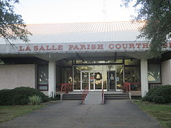
 LaSalle Parish Courthouse in Jena LaSalle Parish Courthouse in Jena | |
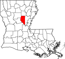
 Location within the U.S. state of Louisiana Location within the U.S. state of Louisiana | |
 Louisiana's location within the U.S. Louisiana's location within the U.S. | |
| Country | |
| State | |
| Region | Central Louisiana |
| Founded | January 1, 1910 |
| Named for | René-Robert Cavelier, Sieur de La Salle |
| Parish seat (and largest town) | Jena |
| Area | |
| • Total | 1,710 km (662 sq mi) |
| • Land | 1,620 km (625 sq mi) |
| • Water | 100 km (38 sq mi) |
| Population | |
| • Total | 14,791 |
| • Density | 8.6/km (22/sq mi) |
| Time zone | UTC-6 (CST) |
| • Summer (DST) | UTC-5 (CDT) |
| Area code | 318 |
| Congressional district | 5th |

LaSalle Parish (French: Paroisse de La Salle) is a parish located in the U.S. state of Louisiana. As of the 2020 United States Census, the population was 14,791. The parish seat is Jena. The parish was created in 1910 from the western section of Catahoula Parish.
Name
The parish is named for René-Robert Cavelier, Sieur de La Salle.
There is some confusion as to whether the parish is spelled "LaSalle" (no space) or "La Salle." An example of the latter view can be seen in the photo at right of the sign over the entrance to a "La Salle Parish Courthouse." A photo of this sign is also featured on the main webpage of the LaSalle Parish Clerk of Court, but the parish is consistently spelled "LaSalle" (no space) in the website text. The prevailing spelling of the parish is "LaSalle" (no space), consistent with the U.S. Census since 2011, and as demonstrated for example by a Google Trends comparison of the phrase's different spellings.
History
The parish was established (as the Parish of LaSalle) on July 3, 1908.
Geography
According to the U.S. Census Bureau, the parish has a total area of 662 square miles (1,710 km), of which 625 square miles (1,620 km) is land and 38 square miles (98 km) (5.7%) is water.
Major highways
Adjacent parishes
- Caldwell Parish (north)
- Catahoula Parish (east)
- Avoyelles Parish (south)
- Rapides Parish (southwest)
- Grant Parish (west)
- Winn Parish (northwest)
National protected area
Demographics
| Census | Pop. | Note | %± |
|---|---|---|---|
| 1910 | 9,402 | — | |
| 1920 | 9,856 | 4.8% | |
| 1930 | 11,668 | 18.4% | |
| 1940 | 10,959 | −6.1% | |
| 1950 | 12,717 | 16.0% | |
| 1960 | 13,011 | 2.3% | |
| 1970 | 13,295 | 2.2% | |
| 1980 | 17,004 | 27.9% | |
| 1990 | 13,662 | −19.7% | |
| 2000 | 14,282 | 4.5% | |
| 2010 | 14,890 | 4.3% | |
| 2020 | 14,791 | −0.7% | |
| U.S. Decennial Census 1790-1960 1900-1990 1990-2000 2010-2013 | |||
2020 census
| Race | Number | Percentage |
|---|---|---|
| White (non-Hispanic) | 11,263 | 76.15% |
| Black or African American (non-Hispanic) | 1,283 | 8.67% |
| Native American | 133 | 0.9% |
| Asian | 252 | 1.7% |
| Pacific Islander | 10 | 0.07% |
| Other/Mixed | 448 | 3.03% |
| Hispanic or Latino | 1,402 | 9.48% |
As of the 2020 United States census, there were 14,791 people, 4,814 households, and 3,643 families residing in the parish.
2000 census
As of the census of 2000, there were 14,282 people, 5,291 households, and 3,798 families residing in the parish. The population density was 23 people per square mile (8.9 people/km). There were 6,273 housing units at an average density of 10 per square mile (3.9/km). The racial makeup of the parish was 86.13% White, 12.20% Black or African American, 0.64% Native American, 0.18% Asian, 0.01% Pacific Islander, 0.20% from other races, and 0.64% from two or more races. 0.82% of the population were Hispanic or Latino of any race.
There were 5,291 households, out of which 33.60% had children under the age of 18 living with them, 59.00% were married couples living together, 9.80% had a female householder with no husband present, and 28.20% were non-families. 25.70% of all households were made up of individuals, and 13.00% had someone living alone who was 65 years of age or older. The average household size was 2.52 and the average family size was 3.03.
In the parish the population was spread out, with 26.10% under the age of 18, 9.40% from 18 to 24, 27.20% from 25 to 44, 22.60% from 45 to 64, and 14.80% who were 65 years of age or older. The median age was 36 years. For every 100 females there were 100.30 males. For every 100 females age 18 and over, there were 97.20 males.
The median income for a household in the parish was $28,189, and the median income for a family was $36,197. Males had a median income of $27,431 versus $19,697 for females. The per capita income for the parish was $14,033. About 14.90% of families and 18.70% of the population were below the poverty line, including 23.70% of those under age 18 and 18.90% of those age 65 or over.
National Guard
The 1087TH Transportation Company of the 165TH CSS (combat service support) Battalion of the 139TH RSG (regional support group) resides in Jena, Louisiana.
Communities

Towns
Unincorporated areas
Census-designated place
Other unincorporated communities
Notable people
- Thomas "Bud" Brady, member of the Louisiana House of Representatives from 1976 to 1988
- Mike Francis, former Louisiana Republican state chairman
- Henry E. Hardtner, lumberman known as "Louisiana's first conservationist", member of both houses of the Louisiana State Legislature, LaSalle Parish police juror, founder of Urania
- Speedy O. Long, state senator, U.S. representative, district attorney
- Jeffery Simmons, Football player for the Tennessee Titans
Politics
LaSalle Parish has been staunchly Republican since 1956, except in 1968 when it voted strongly for American Independent nominee George Wallace. Prior to that, it had been heavily Democratic, but no Democratic nominee since 1956 besides Jimmy Carter has passed forty percent of the parish’s vote, with Hillary Clinton and Joe Biden not even reaching double digits.
| Year | Republican | Democratic | Third party(ies) | |||
|---|---|---|---|---|---|---|
| No. | % | No. | % | No. | % | |
| 2024 | 6,023 | 90.98% | 546 | 8.25% | 51 | 0.77% |
| 2020 | 6,378 | 90.12% | 638 | 9.02% | 61 | 0.86% |
| 2016 | 5,836 | 88.84% | 605 | 9.21% | 128 | 1.95% |
| 2012 | 5,726 | 87.13% | 764 | 11.63% | 82 | 1.25% |
| 2008 | 5,602 | 85.49% | 860 | 13.12% | 91 | 1.39% |
| 2004 | 5,015 | 80.39% | 1,155 | 18.52% | 68 | 1.09% |
| 2000 | 4,564 | 74.72% | 1,397 | 22.87% | 147 | 2.41% |
| 1996 | 2,925 | 44.96% | 2,543 | 39.09% | 1,038 | 15.95% |
| 1992 | 3,068 | 45.63% | 2,389 | 35.53% | 1,266 | 18.83% |
| 1988 | 4,559 | 71.69% | 1,622 | 25.51% | 178 | 2.80% |
| 1984 | 5,404 | 78.60% | 1,318 | 19.17% | 153 | 2.23% |
| 1980 | 3,792 | 57.16% | 2,665 | 40.17% | 177 | 2.67% |
| 1976 | 3,161 | 50.10% | 2,961 | 46.93% | 188 | 2.98% |
| 1972 | 3,858 | 81.51% | 651 | 13.75% | 224 | 4.73% |
| 1968 | 1,258 | 21.52% | 710 | 12.15% | 3,878 | 66.34% |
| 1964 | 4,319 | 83.33% | 864 | 16.67% | 0 | 0.00% |
| 1960 | 2,123 | 55.26% | 843 | 21.94% | 876 | 22.80% |
| 1956 | 1,885 | 61.56% | 951 | 31.06% | 226 | 7.38% |
| 1952 | 1,692 | 45.82% | 2,001 | 54.18% | 0 | 0.00% |
| 1948 | 266 | 9.67% | 716 | 26.03% | 1,769 | 64.30% |
| 1944 | 504 | 19.78% | 2,018 | 79.20% | 26 | 1.02% |
| 1940 | 258 | 11.18% | 2,039 | 88.38% | 10 | 0.43% |
| 1936 | 256 | 13.48% | 1,643 | 86.52% | 0 | 0.00% |
| 1932 | 117 | 6.30% | 1,738 | 93.64% | 1 | 0.05% |
| 1928 | 450 | 33.81% | 881 | 66.19% | 0 | 0.00% |
| 1924 | 102 | 17.93% | 456 | 80.14% | 11 | 1.93% |
| 1920 | 109 | 15.71% | 570 | 82.13% | 15 | 2.16% |
| 1916 | 20 | 3.13% | 610 | 95.61% | 8 | 1.25% |
| 1912 | 7 | 1.26% | 366 | 65.95% | 182 | 32.79% |
See also
References
- ^ "LaSalle Parish, Louisiana". quickfacts.census.gov. Retrieved January 10, 2022.
- "Find a County". National Association of Counties. Retrieved June 7, 2011.
- "LaSalle Parish". Center for Cultural and Eco-Tourism. Archived from the original on December 22, 2013. Retrieved September 4, 2014.
- "Changes to Counties or County Equivalent Entities: 2010s". census.gov. U.S. Census Bureau. Retrieved January 8, 2022.
- "Google Trends". trends.google.com. Google. Retrieved December 31, 2021.
- U.S. Geological Survey Geographic Names Information System: LaSalle Parish, Louisiana
- "House Bill No. 295". Official Journal of the Proceedings of the House of Representatives of the State of Louisiana at the First Regular Session of the Third General Assembly. Baton Rouge, Louisiana: The Daily State Publishing Company: 991. 1908 – via Google Books.
- "2010 Census Gazetteer Files". United States Census Bureau. August 22, 2012. Archived from the original on September 28, 2013. Retrieved September 1, 2014.
- "U.S. Decennial Census". United States Census Bureau. Retrieved September 1, 2014.
- "Historical Census Browser". University of Virginia Library. Retrieved September 1, 2014.
- "Population of Counties by Decennial Census: 1900 to 1990". United States Census Bureau. Retrieved September 1, 2014.
- "Census 2000 PHC-T-4. Ranking Tables for Counties: 1990 and 2000" (PDF). United States Census Bureau. Archived (PDF) from the original on March 27, 2010. Retrieved September 1, 2014.
- "Explore Census Data". data.census.gov. Retrieved December 29, 2021.
- "U.S. Census website". United States Census Bureau. Retrieved January 31, 2008.
- Leip, David. "Dave Leip's Atlas of U.S. Presidential Elections". uselectionatlas.org. Retrieved March 7, 2018.
External links
| Municipalities and communities of LaSalle Parish, Louisiana, United States | ||
|---|---|---|
| Parish seat: Jena | ||
| Towns |  | |
| CDPs | ||
| Other unincorporated communities | ||
| Indian reservation | ||
| Footnotes | ‡This populated place also has portions in an adjacent parish or parishes | |
31°41′N 92°10′W / 31.68°N 92.16°W / 31.68; -92.16
Categories: