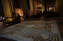
The Labyrinth of the Reims Cathedral was a church labyrinth installed on the floor of the nave of the Reims Cathedral.
Structure
The labyrinth was the shape of a complex square with cut corners and sides of 10.36 metres (11.33 yd) . The paths were 27.94 centimetres (11.00 in) wide, separated by lines of dark blue stone from Ardennes of a width of 11.43 centimetres (4.50 in). The labyrinth was made of soft stone that wore out beneath the feet of pilgrims. This stone was of the same kind as Pierre Libergier's tombstone that is now exhibit in the cathedral.
A distinctive aspect of the labyrinth was the inclusion within it of depictions of the master masons of the cathedral. In other churches and cathedrals, they are unknown and anonymous. Indeed, the identities of these master masons are precisely known, because a survey of the labyrinth was drawn in 1640 by Canon Cocquault and in 1779, just before its destruction, by Robin and Havé. These surveys also contained dates and descriptions of the masons' works.
The person at the center of the labyrinth is generally identified as Aubry de Humbert, Archbishop of Reims, who decided in 1211 to build a new cathedral in the place of the one destroyed by fire in 1210.
The people in the corners of the labyrinth are successive master masons of the cathedral:
- (Top right) : Jean Orbais (1211-1231) made the plans of the cathedral and began the apse.
- (Top left) : Jean-le-Loup [fr] (1231-1247) began the northern portals.
- (Bottom left) : Gaucher de Reims [fr] (1247-1255) began the arches and portals on the western façade.
- (Bottom right) : Bernard de Soissons (1255-1290) made five vaults of the nave and the great rosace.
Bernard de Soissons was in charge during the inauguration of the labyrinth. There is no trace of the fifth (and probably best-known) contractor, Robert de Coucy, who was in charge from 1290 to 1311 and who oversaw the carpentry and the roof.
The masons are represented hard at work, with their tools in hand. For example, Jean d'Orbais appears to draw a map on the floor.
There were also two other silhouettes on each side of the entrance of the labyrinth; however, these could not be identified because they were already almost completely eroded.

History
The church labyrinths were polychrome pavements symbolizing the rise of Christ at Calvary. Christian people followed them on their knees as a symbolic pilgrimage or to win indulgences
The labyrinth was inaugurated at the coronation of Philippe le Bel on 6 January 1286. It covered the central part of the nave at the third and fourth spans.
The labyrinth was destroyed in 1779 by the Canons (priests charged with running the cathedral).

Reconstruction project
A plan to rebuild the labyrinth ran into technical and administrative difficulties. Instead, a choice was made to undertake a reversible and nondamaging reconstruction. This took the form of a light projection on the ground that plays only in the evening, during cultural events. It was inaugurated on 19 September 2009.
Logo of historical monuments
The labyrinth has been chosen as the national logo for French historical monuments ("monuments historiques"). This logo depicts the labyrinth without people, rotated by 45°, and often in a dark red color.

References
- ^ "Le labyrinthe disparu de la cathédrale de Reims" (in French). Charte de Fontevrault. Retrieved 2014-01-06.
- ^
Naert, Dominique (1996). Le labyrinthe de la cathédrale de Reims [Labyrinth of the Reims Cathedral] (in French). 29 rue Gay- Lussac, 94120 Fontenay -sous -Bois: SIDES. p. 96. ISBN 978-2-86861-073-7.
{{cite book}}: CS1 maint: location (link) - ^ Yann Harlaut. "Bienvenue à la découverte de ce joyau de l'art gothique" (in French). Retrieved 2014-01-06.
- ^ "Reims Our Lady Cathedral" (in French). Direction régionale des affaires culturelles de Champagne-Ardenne. Retrieved 2014-01-06.
Bibliography
- Naert, Dominique (1996). Le labyrinthe de la cathédrale de Reims [Labyrinth of the Reims Cathedral] (in French). 29 rue Gay- Lussac, 94120 Fontenay -sous -Bois: SIDES. p. 96. ISBN 978-2-86861-073-7.
{{cite book}}: CS1 maint: location (link)
49°15′14″N 4°02′02″E / 49.2539°N 4.0339°E / 49.2539; 4.0339
Categories:- 1286 establishments in Europe
- 1280s establishments in France
- Buildings and structures completed in 1286
- 1779 disestablishments in France
- Buildings and structures demolished in 1779
- Mazes in France
- World Heritage Sites in France
- Buildings and structures in Reims
- Landmarks in France
- Gothic architecture in France
- Church architecture
- Cathedrals
- Labyrinths
- Philip IV of France