Municipality in Quebec, Canada
| Lac-Sainte-Marie | |
|---|---|
| Municipality | |
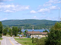
 municipal office and Sainte-Marie Lake municipal office and Sainte-Marie Lake | |
 | |
| Coordinates: 45°57′N 75°57′W / 45.95°N 75.95°W / 45.95; -75.95 | |
| Country | Canada |
| Province | Quebec |
| Region | Outaouais |
| RCM | La Vallée-de-la-Gatineau |
| Settled | 1840s |
| Constituted | January 1, 1872 |
| Government | |
| • Mayor | Cheryl Sage Christensen |
| • Federal riding | Pontiac |
| • Prov. riding | Gatineau |
| Area | |
| • Total | 240.15 km (92.72 sq mi) |
| • Land | 205.71 km (79.43 sq mi) |
| Population | |
| • Total | 677 |
| • Density | 3.3/km (9/sq mi) |
| • Pop (2016–21) | |
| • Dwellings | 930 |
| Time zone | UTC−5 (EST) |
| • Summer (DST) | UTC−4 (EDT) |
| Postal code(s) | J0X 1Z0 |
| Area code | 819 |
| Website | www |
Lac-Sainte-Marie (French pronunciation: [lak sɛ̃t maʁi]) is a municipality in the La Vallée-de-la-Gatineau Regional County Municipality, Quebec, Canada, 60 kilometres (37 mi) north of Gatineau. It is named after the adjacent lake.
History
In 1840, the area was opened to settlement, and that same year the Saint-Nom-de-Marie Parish was founded. The municipality was formed in 1872. It was originally called Hincks, in honour of politician Sir Francis Hincks (1807-1885), who was then finance minister in the Macdonald cabinet. After this cabinet fell in 1873, Hincks’ name was replaced in popular usage by the name of the parish, and then by the name of the lake. In 1882, the post office opened, using the English name Lake St. Mary and renamed to Lac-Sainte-Marie in 1916.
In 1928 the village was flooded to create the Paugan hydroelectric dam. Ninety percent of the village had to be relocated to higher ground, including the church (St-Nom-de-Marie parish) located in the centre of the old town.
St-Nom-de-Marie parish was built in 1904-1905 and then moved to its actual site because of the Paugan dam construction, completed in 1929. Religious presence, however, dates back to 1840, the year the first chapel was built.
The submerged town attracted the attention of many tourists from the cities of Ottawa and Gatineau, and in 1975, Lac-Sainte-Marie became the official name, which paid tribute to a forgotten pioneer, Marie Léveillée, mother of Jean-Marie Léveillée who was the first settler in the area.
Demographics
|
| ||||||||||||||||||||||||||||||||||||
| Source: Statistics Canada | |||||||||||||||||||||||||||||||||||||
Private dwellings occupied by usual residents (2021): 374 (out of 930 total)
Mother tongue languages (2021):
- French as first language: 74%
- English as first language: 22%
- English and French as first language: 2%
See also
References
- ^ "Banque de noms de lieux du Québec: Reference number 33337". toponymie.gouv.qc.ca (in French). Commission de toponymie du Québec.
- ^ "Répertoire des municipalités: Geographic code 83020". www.mamh.gouv.qc.ca (in French). Ministère des Affaires municipales et de l'Habitation.
- ^ "Lac-Sainte-Marie census profile". 2021 Census data. Statistics Canada. Retrieved 2022-04-25.
- ^ "Municipality of Lac-Sainte-Marie - St-Nom-de-Marie Church". www.lac-sainte-marie.com. Retrieved 2021-07-17.
- 1996, 2001, 2006, 2011 census
External links
 Media related to Lac-Sainte-Marie at Wikimedia Commons
- www
.lac-sainte-marie .com  official website
| Places adjacent to Lac-Sainte-Marie, Quebec | ||||||||||||||||
|---|---|---|---|---|---|---|---|---|---|---|---|---|---|---|---|---|
| ||||||||||||||||
| Cities | |
|---|---|
| Municipalities | |
| Townships | |
| Unorganized territories | |
| |