| Lake Boga | |
|---|---|
| Boga Lake | |
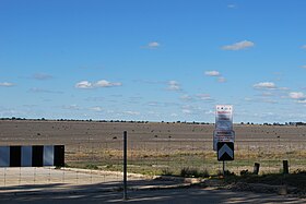
 The empty lake, pictured in 2009. The empty lake, pictured in 2009. | |
 | |
| Location | The Mallee, Victoria |
| Coordinates | 35°26′59.6″S 143°38′40.2″E / 35.449889°S 143.644500°E / -35.449889; 143.644500 |
| Type | Freshwater endorheic water storage |
| Primary outflows | outfall channel to the Little Murray River |
| Basin countries | Australia |
| Managing agency | Goulburn–Murray Water |
| Surface area | 940 ha (2,300 acres) |
| Max. depth | 2 metres (6 ft 7 in) |
| Water volume | 37,794 megalitres (8.314×10 |
| Surface elevation | 69.5 metres (228 ft) AHD |
| References | |
Lake Boga ( /ˈleɪk ˈboʊɡə/), a freshwater endorheic lake that is managed by Goulburn–Murray Water as a water storage, is part of the Victorian Mid Murray Storages, is located near Swan Hill in The Mallee region of Victoria, in southeastern Australia. The 940-hectare (2,300-acre) lake is situated about 19 kilometres (12 mi) southeast of Swan Hill and adjacent to the town of the same name.
During World War II, Lake Boga was used as a repair and service depot for flying boats at the Lake Boga Flying Boat Base which was established in June 1942 and closed in November 1947.
Water storage
Lake Boga has a capacity of 37,794 megalitres (8.314×10^ imp gal; 9.984×10^ US gal) at the full supply level of 69.5 metres (228 ft) AHD and a surface area of 940 hectares (2,300 acres). Under normal operation, water levels in Lake Boga vary between levels of 69.5 metres (228 ft) AHD and 67.22 metres (220.5 ft) AHD. At the level of 67.22 metres (220.5 ft) AHD, there is a depth of up to 2 metres (6 ft 7 in) of water in the deepest parts of the lake. Although operation and lake levels will vary from season to season, in general water will be harvested into Lake Boga during the winter and spring months. Subject to sufficient water to
harvest, the lake generally will be full around November to December.
In 2009, after a period of the lake being dry, water started flowing into the lake during 2010, and by 2011, the lake was one of many rivers and water storage facilities in Victoria that was flooded as a result of the 2011 Victorian floods.
See also
References
- ^ "Lake Boga (VIC)". Gazetteer of Australia online. Geoscience Australia, Australian Government.
- "Lake Boga (entry )". VICNAMES. Government of Victoria.
- "Map of Lake Boga, VIC". Bonzle Digital Atlas of Australia. Retrieved 6 November 2014.
- ^ "Lake Boga: Recreational Guide" (PDF). Goulburn–Murray Water (PDF). October 2012. Archived from the original (PDF) on 21 March 2015. Retrieved 7 November 2014.
- "Lake Boga Land and On-Water Management Plan" (PDF). Victorian Mid Murray Storages (PDF). 2014. Archived from the original (PDF) on 6 November 2014. Retrieved 6 November 2014.
- "Water authority mulls Lake Boga refill". ABC News. Australia. 20 October 2009. Retrieved 7 November 2014.
- "Water flows into Lake Boga". ABC News. Australia. 9 April 2010. Retrieved 7 November 2014.
- "Inland sea set to swamp more towns". ABC News. Australia. 23 January 2011. Retrieved 7 November 2014.
External links
- "Lake Boga". Victorian Mid Murray Storages. 2014. Archived from the original on 6 November 2014. Retrieved 6 November 2014.
| Lakes and other waterbodies of Victoria, Australia | |||||||||||||||||
|---|---|---|---|---|---|---|---|---|---|---|---|---|---|---|---|---|---|
| |||||||||||||||||
| |||||||||||||||||
| Water supply in Victoria, Australia | |
|---|---|
| Greater Metropolitan Melbourne dams / reservoirs by capacity |
|
| Regional dams / reservoirs |
|
| Other water sources / facilities | |
| Water companies and government agencies |
|
| Historical | |
This article about a location in Victoria, Australia is a stub. You can help Misplaced Pages by expanding it. |