| Chatyr-Köl | |
|---|---|
| Чатыр-Көл (Kyrgyz) | |
 | |
  | |
| Location | Tian Shan mountains, Naryn Region |
| Coordinates | 40°37′N 75°18′E / 40.617°N 75.300°E / 40.617; 75.300 |
| Type | Endorheic Mountain lake |
| Primary inflows | Glaciers |
| Primary outflows | Evaporation |
| Catchment area | 1,050 km (410 sq mi) |
| Basin countries | Kyrgyzstan |
| Designation | Ramsar site |
| Max. length | 23 km (14 mi) |
| Max. width | 10 km (6.2 mi) |
| Surface area | 181 km (70 sq mi) |
| Max. depth | 16.5 m (54 ft) |
| Water volume | 0.62 km (0.15 cu mi) |
| Shore length | 58 km (36 mi) |
| Surface elevation | 3,530 m (11,580 ft) |
| Islands | none |
| Settlements | none |
| Ramsar Wetland | |
| Official name | Chatyr Kul |
| Designated | 8 November 2005 |
| Reference no. | 1588 |
| Shore length is not a well-defined measure. | |
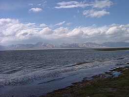
Chatyr-Köl (Kyrgyz: Чатыр-Көл, Russian: Чатыр-Куль, romanized: Chatyr-Kul') is an endorheic alpine lake in the Tian Shan mountains in At-Bashy District of Naryn Province, Kyrgyzstan; it lies in the lower part of Chatyr-Köl Depression near the Torugart Pass border crossing into China. The name of the lake means “Celestial Lake” in Kyrgyz (literally "Roof Lake").
Climate
The mean annual temperature in the lake basin is −5.6 °C (21.9 °F), with mean temperature of −22 °C (−8 °F) in January, and 7.1 °C (44.8 °F) in July. The maximum temperature in summer is 24 °C (75 °F), and the minimum one in winter is −50 °C (−58 °F). Some 88-90% of the lake basin's 208–269 mm of annual precipitation falls in summer. From October to end of April the lake surface freezes, the ice becoming as much as 0.25-1.5 m thick.
Hydrology
The water of Chatyr Kul Lake is yellowish-green with water transparency of up to 4 metres (13 ft). The mineralization of the lake ranges from 0.5 to 1.0 milligrams per liter (chloride, hydrocarbonate, sodium and magnesium type of mineralization). The salinity of the lake is 2 ppt. Mineral sources in the south part of the lake have mineralization of from 5 to 7 grams (0.18 to 0.25 oz) per liter and pH = 5,8-6,0. Flow rate is 1,866 m (65,900 cu ft) in winter and 3,629 cubic metres (128,200 cu ft) during summer. 41 small streams debouches into the lake, of those 21 originate in Torugart Range and 20 - in Atbashy Range.
Negative water balance of the lake over the last decades causes the decline in the lake level. The mineral water from the sources is cold and has a strong mineral taste and flow first into the small Chatyr Kul lake that is about 1,5 meters higher than the actual Chatyr Kul.
Protection
Since 1998, a section of the lake and its shore (3,200 ha land, 3,954 ha water) is protected as part of the Karatal-Japyryk Nature Reserve. The whole lake has been a game reserve (IUCN category IV) since 1972. The game reserve was established to protect water fowl, including the bar-headed goose. The lake is a Ramsar site of globally significant biodiversity (Ramsar Site RDB Code 2KG002).
Gallery
-
 Map of the region including the Ozero Chatyr-Kul' (AMS, 1948)
-
 Map of the region including the Ozero Chatyr-kel' (DMA, 1985)
References
- ^ "Chatyr Kul". Ramsar Sites Information Service. Retrieved 25 April 2018.
- Атлас Кыргызской Республики [Atlas of Kyrgyz Republic] (in Russian). Bishkek: Academy of Sciences of Kyrgyz SSR. 1987. p. 156.
- Иссык-Куль. Нарын:Энциклопедия [Encyclopedia of Issyk-Kul and Naryn Oblasts] (in Russian). Bishkek: Chief Editorial Board of Kyrgyz Soviet Encyclopedia. 1994. p. 512. ISBN 5-89750-009-6.
- "Information Sheet on Ramsar Wetlands" (PDF). Retrieved October 30, 2012.
- "Чатыркөл" [Chatyrköl] (PDF). Кыргызстандын Географиясы (in Kyrgyz). Bishkek. 2004. p. 220.
{{cite encyclopedia}}: CS1 maint: location missing publisher (link) - "Central Asia Guide". Central Asia Guide. Archived from the original on 2021-06-04.
- "Karatal-Japyryk Nature Reserve". Specially Protected Areas and Biodiversity of Kyrgyzstan (in Russian). Retrieved 12 January 2022.
- "Chatyrkul". protected planet.
- "Чатыркөл заказниги" [Chatyr-Köl Reserve] (PDF). Кыргызстандын Географиясы (in Kyrgyz). Bishkek. 2004. p. 311.
{{cite encyclopedia}}: CS1 maint: location missing publisher (link)
| Protected areas of Kyrgyzstan | |
|---|---|
| Nature Reserves (IUCN Category I) | |
| Nature Parks (IUCN Category II) | |
| Nature Monuments (IUCN Category III) |
|
| Integrated Reserves (IUCN Category IV) | |
| Botanical Reserves (IUCN Category IV) |
|
| Game Reserves (IUCN Category IV) | |
| Forest Reserves (IUCN Category IV) | |