| Lake Cootapatamba | |
|---|---|
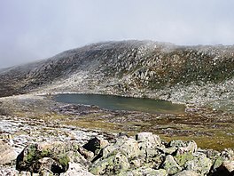
 View of Lake Cootapatamba from the Thredbo-Rawsons Pass walking track View of Lake Cootapatamba from the Thredbo-Rawsons Pass walking track | |
 | |
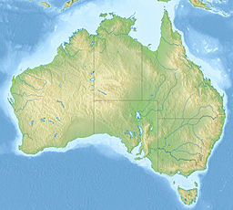
| Location | Kosciuszko National Park, New South Wales, Australia |
| Coordinates | 36°27′55″S 148°15′51″E / 36.4652°S 148.2643°E / -36.4652; 148.2643 |
| Type | Tarn |
| Max. length | 400 m (1,300 ft) |
| Max. depth | 5 m (16 ft) |
| Surface elevation | 2,048 m (6,719 ft) |
| Frozen | June to October/November |
Lake Cootapatamba is a post-glacial tarn in the Kosciuszko National Park, New South Wales, Australia.
Lake Cootapatamba is located at 2,048 metres, which is about 800 metres south of the summit of Mount Kosciuszko, the highest peak in Australia. It is the highest elevation lake in Australia. It is 400 metres long with a maximum depth of about 5 metres.
References
- West,D., (1994) Kosciuszko Natural Heritage.
- ElevationMap.net. "Elevation of Lake Cootapatamba with altitude and height". Retrieved 27 December 2016.
- "Tourists on the Monaro - KOSCIUSKO". Retrieved 4 July 2018.
| Lakes and other natural bodies of water in New South Wales, Australia | |
|---|---|
| Coastal lagoons and lakes | |
| Freshwater | |
| Glacial | |
| Saline | |
| Townships and Villages | |
|---|---|
| Localities and rural places | |
| National parks and other natural features | |
| Rivers and other watercourses | |
| Dams and/or associated reservoirs | |
| Mountain ranges | |
| Attractions | |
| Main Article: Local government areas of New South Wales | |
This New South Wales geography article is a stub. You can help Misplaced Pages by expanding it. |