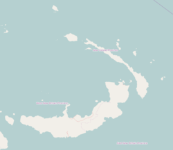
| Lambom | |
|---|---|
| Village | |
 | |
| Coordinates: 4°48′S 152°51′E / 4.800°S 152.850°E / -4.800; 152.850 | |
| Country | |
| Province | New Ireland Province |
| District | Namatanai District |
Lambom is a village on the south-west coast of New Ireland, Papua New Guinea, south of Lamassa. Lambom Island lies off the coast. It is located in Konoagil Rural LLG.
References
- Firth, Stewart (1 July 1983). New Guinea under the Germans. Melbourne University Press. ISBN 978-0-522-84220-3. Retrieved 31 December 2012.
- United Nations in Papua New Guinea (2018). "Papua New Guinea Village Coordinates Lookup". Humanitarian Data Exchange. 1.31.9.
This New Ireland Province geography article is a stub. You can help Misplaced Pages by expanding it. |