Commune in Occitanie, France
You can help expand this article with text translated from the corresponding article in French. (December 2008) Click for important translation instructions.
|
| Puilaurens | |
|---|---|
| Commune | |
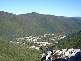
 A general view of Puilaurens A general view of Puilaurens | |
 Coat of arms Coat of arms | |
| Location of Puilaurens | |
  | |
| Coordinates: 42°48′38″N 2°18′21″E / 42.8106°N 2.3058°E / 42.8106; 2.3058 | |
| Country | France |
| Region | Occitania |
| Department | Aude |
| Arrondissement | Limoux |
| Canton | La Haute-Vallée de l'Aude |
| Intercommunality | Pyrénées Audoises |
| Government | |
| • Mayor (2020–2026) | Jacques Galy |
| Area | 33.38 km (12.89 sq mi) |
| Population | 272 |
| • Density | 8.1/km (21/sq mi) |
| Time zone | UTC+01:00 (CET) |
| • Summer (DST) | UTC+02:00 (CEST) |
| INSEE/Postal code | 11302 /11140 |
| Elevation | 399–1,420 m (1,309–4,659 ft) (avg. 424 m or 1,391 ft) |
| French Land Register data, which excludes lakes, ponds, glaciers > 1 km (0.386 sq mi or 247 acres) and river estuaries. | |
Puilaurens (French pronunciation: [pɥiloʁɑ̃s] , also non-officially: Lapradelle-Puilaurens; Occitan: La Pradèla de Puèglhaurenç) is a commune in the Aude department in southern France.
It includes the hamlets of Lapradelle, Puilaurens and Lavignac. It is known for the medieval Puilaurens Castle.
Geography
The commune is situated on the Boulzane river and the Green Meridian.
History
The built-up area of Lapradelle did not exist until the 19th century and owes its development to activities related to water power taken from the Boulzane: textile spinning and sawmills.
In 1904, a railway was constructed from Quillan to Rivesaltes (the Carcassonne - Rivesaltes Line) passing through Lapradelle on a viaduct spanning the valley of the Boulzane. The line carried passengers until 1939. Afterwards it was used to transport feldspar between the Aude and the Pyrénées-Orientales, the railway line is today used in the summer for a tourist train, running between Axat and Rivesaltes.
In 1868, Puilaurens lost the hamlets of Salvezines and Le Caunil, established as the separate commune of Salvezines.
Population
Its inhabitants are called Puilaurenois.
| Year | Pop. | ±% |
|---|---|---|
| 1962 | 324 | — |
| 1968 | 378 | +16.7% |
| 1975 | 257 | −32.0% |
| 1982 | 222 | −13.6% |
| 1990 | 219 | −1.4% |
| 1999 | 236 | +7.8% |
| 2006 | 252 | +6.8% |
| 2007 | 254 | +0.8% |
| 2012 | 265 | +4.3% |
| 2015 | 266 | +0.4% |
See also
References
- "Répertoire national des élus: les maires". data.gouv.fr, Plateforme ouverte des données publiques françaises (in French). 2 December 2020.
- "Populations de référence 2022" (in French). The National Institute of Statistics and Economic Studies. 19 December 2024.
This Aude geographical article is a stub. You can help Misplaced Pages by expanding it. |