| Lend | |
|---|---|
| 4th city district of Graz | |
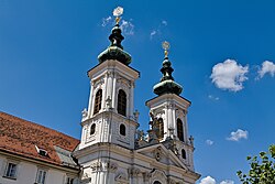
 Church Mariahilf Church Mariahilf | |
| Country | |
| Province | Styria |
| Statutory city | Graz |
| Area | |
| • Total | 3.70 km (1.43 sq mi) |
| Population | |
| • Total | 32,859 |
| • Density | 8,900/km (23,000/sq mi) |
Lend (German pronunciation: [lɛnt] ) is the 4th district of the Austrian city of Graz. It is located on the west bank of the Mur and north of the district Gries and west of the district Innere Stadt and the Schloßberg.
It has a population of 32,859 (in 2023) and covers an area of 3.7 square kilometres. The postal codes of Lend are 8020 and 8051.
Points of interest
- Kalvarienbergkirche and Kalvarienberg
- Mariahilfer Kirche
- Grazer Kunsthaus
- Grazer Orpheum, a small theater built in 1899
References
- Service), Stadtportal der Landeshauptstadt Graz, Admin (Graz Press. "Zahlen + Fakten: Bevölkerung, Bezirke, Wirtschaft, Geografie". Stadtportal der Landeshauptstadt Graz (in German). Retrieved 2023-11-01.
{{cite web}}: CS1 maint: multiple names: authors list (link) - Clay, Xpert Design Junior Company - http://www.xpert-design.magnet.at - Christopher. "Kalvarienbergkirche Wien · Pfarre Hernals: Angebote, Gottesdienste & Messen, Konzerte, Kindertagesheim ..." www.kalvarienbergkirche.at. Retrieved 2017-12-13.
{{cite web}}: External link in|first= - Pfarrgemeinderat. "Pfarre Mariahilf - Willkommen/Mariahilf". www.pfarremariahilf.at (in German). Retrieved 2017-12-13.
| Districts of Graz | ||
|---|---|---|
 | ||
47°04′41″N 15°25′34″E / 47.078°N 15.426°E / 47.078; 15.426
This Styria location article is a stub. You can help Misplaced Pages by expanding it. |