Municipality in Quebec, Canada
| Les Îles-de-la-Madeleine | |
|---|---|
| Municipality | |
 Grindstone Grindstone | |
| Motto(s): "Et si" (French for, "And If") | |
 Location within Les Îles-de-la-Madeleine TE. Location within Les Îles-de-la-Madeleine TE. | |
 | |
| Coordinates: 47°24′N 61°48′W / 47.400°N 61.800°W / 47.400; -61.800 | |
| Country | Canada |
| Province | Quebec |
| Region | Gaspésie–Îles-de-la-Madeleine |
| RCM | None |
| Agglomeration | Îles-de-la-Madeleine |
| Constituted | January 1, 2002 |
| Government | |
| • Mayor | Antonin Valiquette |
| • Federal riding | Gaspésie—Les Îles-de-la-Madeleine |
| • Prov. riding | Îles-de-la-Madeleine |
| Area | |
| • Total | 33,704.00 km (13,013.19 sq mi) |
| • Land | 155.06 km (59.87 sq mi) |
| Population | |
| • Total | 12,190 |
| • Density | 78.6/km (204/sq mi) |
| • Pop 2016-2021 | |
| • Dwellings | 6,413 |
| Time zone | UTC−04:00 (AST) |
| • Summer (DST) | UTC−03:00 (ADT) |
| Postal code(s) | G4T 1A1 |
| Area code(s) | 418 and 581 |
| Highways | |
| Website | www |
Les Îles-de-la-Madeleine (French pronunciation: [lez‿il də la madlɛn]) is a municipality located in Gaspésie-Îles-de-la-Madeleine region, in Quebec, Canada. It is located on the islands of the Magdalen Islands archipelago, in the Gulf of St. Lawrence, 250 km (160 mi) from Gaspé, 120 km (75 mi) from Prince Edward Island, 90 km (56 mi) from Cape Breton Island, and 150 km (93 mi) from Newfoundland.
History

The Mi'kmaq were among the original occupants of Atlantic Canada, inhabiting the coastal regions of the Gaspé Peninsula and The Maritimes east of the Saint John River. This traditional territory is called Mi'gma'gi (Mi'kma'ki).
According to Mi'kmaq oral history and archaeological evidence collected to date, there has been a seasonal First Nations presence on the Magdalen Islands for 6,000 to 10,000 years. This occupation was mainly for summer fishing and hunting, marine mammals or other game.
The explorer Jacques Cartier was the first known European to visit the islands in 1534.
The first concerted settlement attempt was made by English Brownist (a group of English Dissenters or separatists) Francis Johnson in 1597, which failed. François Doublet de Honfleur received the concession of the archipelago from the Company of One Hundred Associates (Compagnie des Cent-Associés), in 1663, he gave it its current name, in honour of his wife Madeleine Fontaine.
The first real settlers to settle on the islands came after the fall of Louisbourg and the dispersal of the Acadians from the Grand-Pré region of Acadia.

In 1765, the islands were inhabited by 22 French-speaking Acadians and their families. They were working and hunting walruses for a British trader, Richard Gridley. Many inhabitants of Les Îles-de-la-Madeleine still fly the Acadian flag and identify as both Acadian and Québécois. The islands were administered as part of the British Colony of Newfoundland from 1763 to 1774, when they became part of the Province of Quebec (1763–1791) by the Quebec Act passed by the Parliament of Great Britain.

Some of the islanders are descendants of survivors of the more than 400 shipwrecks on the islands. Some of the historic houses were built using wood that was salvaged from the shipwrecks.
Once, 48 ships sank during a single storm.
— BBC
The islands have some of Quebec's oldest English-speaking settlements. Although most anglophones have long either assimilated with the francophone population or migrated elsewhere, English-speaking settlements are found at Old Harry, a hamlet in Grosse-Île, and Entry Island. To improve the safety of ships, the government constructed lighthouses on the islands. They indicate navigable channels and have reduced the number of shipwrecks, but many old hulks are found on the beaches and under the waters.
Until the 20th century, the islands were completely isolated during the winter since the sea ice made the trip to the mainland impassable by boat. In August 1880, the Canadian Government's telegraphy service installed the first submarine cable that connected the islands with the mainland.
On January 6, 1910, this cable connecting the village of Old Harry, Magdalen Islands, to Sydney, Cape Breton Island, Nova Scotia, broke. On February 2, 1910, Magdalen Islanders, cut off from the rest of the world, threw into the sea a ponchon, that is to say, a barrel containing the original molasses, the wooden barrel, equipped with a rudder and a sheet metal sail on which they had painted the inscription "Winter Magdalen Mail". In the ponchon, it has letters placed in sealed tin cans, these letters are addressed to families on the continent, except one written for the person who would find the makeshift boat and another addressed to Rodolphe Lemieux, Member of Parliament for Gaspé and Postmaster General. The ponchon reached Halifax around February 14, 1910. A year later, the Government of Canada responded to the Magdalen Islanders' grievances and installed a wireless telegraphy system in the Islands.
Geography
Created in 2002, the municipality of Les Îles-de-la-Madeleine is the result of the merger of multiple municipalities within the archipelago.
As part of a municipal reorganization across Quebec, the seven communities of the Magdalen Islands amalgamated to form the municipality of Les Îles-de-la-Madeleine on January 1, 2002. Grosse-Île has since regained its status as a separate municipality; the list below presents the six hamlets of Les Îles-de-la-Madeleine.
L'Étang-du-Nord

L'Étang-du-Nord is the main fishing centre of the Les Îles-de-la-Madeleine, the place received its first inhabitants around 1830 and was officially erected as a municipality in 1875. The community hosts a campus of Cégep de la Gaspésie et des Îles, the Magdalen Islands' only post-secondary institution.
Fatima

Located on the island of Cap-aux-Meules, Fatima was settled between 1820 and 1845. It is named after Fátima in Portugal, a pilgrimage site highly visited after three young shepherds claimed the Holy Virgin appeared to them. Its population, as of 2006, was 2,809.
L’Île-du-Havre-Aubert
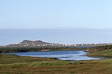

The hamlet of L’Île-du-Havre-Aubert is made up of the island of Havre-Aubert and the island of L’ Île-d’Entrée.
Havre-aux-Maisons
Havre-aux-Maisons, located on the island of Havre aux Maisons, was first settled in 1765 from Acadia.
Îles-de-la-Madeleine Airport, Magdalen Islands' only port of entry by air, is located on Havre-aux-Maisons.
Cap-aux-Meules
Main article: Cap-aux-MeulesCap-aux-Meules, is the largest commercial and fishing port in the archipelago as well as maritime links to the outside world Coopérative de Transport Maritime et Aérien (CTMA),
Grande-Entrée
Grande-Entrée is located on Grande Entrée Island, the hamlet is made up of two points of land facing each other which, between their arms, form a bay where boats can enter as if in a natural harbour, hence the name Grande-Entrée.
Demography
Population
Canada census – Les Îles-de-la-Madeleine community profile| 2021 | 2016 | 2011 | |
|---|---|---|---|
| Population | 12,190 (+1.5% from 2016) | 12,010 (-2.3% from 2011) | 12,291 (-2.1% from 2006) |
| Land area | 155.06 km (59.87 sq mi) | 172.71 km (66.68 sq mi) | 168.11 km (64.91 sq mi) |
| Population density | 78.6/km (204/sq mi) | 69.5/km (180/sq mi) | 73.1/km (189/sq mi) |
| Median age | 54.8 (M: 54.4, F: 54.8) | 52.2 (M: 52.1, F: 52.4) | 48.3 (M: 48.0, F: 48.6) |
| Private dwellings | 6,413 (total) 5,610 (occupied) | 6,223 (total) | 5,924 (total) |
| Median household income | $75,000 | $61,029 | $52,220 |
References: 2021 2016 2011 earlier
|
| ||||||||||||||||||
Language
The language of the Les Îles-de-la-Madeleine is made up of the language of France and Acadia, the language of the sea and the coasts, the influences of English, the additions made, from the beginning of the 19th century by sailors and traders of Jersey in the Channel Islands, and there are also the contributions of the Mi'kmaq language and Quebec French.
In its maritime and island environment, Madelinian culture draws the colours of its language from multiple crucibles of identity, the sea, the dunes, the wind, the mist where the roots of Acadia, Quebec, the Jersey islands, the distant echoes of the First Nations, and others, where a unique culture mixes and knits together.
Over the years and as a result of the numerous shipwrecks, the population of the municipality increases on both sides of the linguistic and religious barrier, but the proportion of Anglophones never exceed 3%.
| Canada census mother tongue - Les Îles-de-la-Madeleine, Quebec | ||||||||||||||||||
|---|---|---|---|---|---|---|---|---|---|---|---|---|---|---|---|---|---|---|
| Census | Total | French | English | French & English | Other | |||||||||||||
| Year | Responses | Count | Trend | Pop % | Count | Trend | Pop % | Count | Trend | Pop % | Count | Trend | Pop % | |||||
| 2021 | 12,075 | 11,720 | 97.1% | 245 | 2.0% | 70 | 0.6% | 35 | 0.3% | |||||||||
| 2016 | 11,890 | 11,585 | 97.4% | 240 | 2.0% | 30 | 0.3% | 35 | 0.3% | |||||||||
| 2011 | 12,180 | 11,850 | 97.3% | 270 | 2.2% | 35 | 0.3% | 25 | 0.2% | |||||||||
| 2006 | 12,445 | 12,005 | n/a | 96.5% | 325 | n/a | 2.6% | 50 | n/a | 0.4% | 65 | n/a | 0.5% | |||||
Attractions
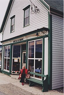
La Grave heritage site includes buildings with a variety of functions: general store, salt works, tinsmith's shop, fishing tackle store, fish sales counter, small warehouses and scaffolds.
Infrastructure
Transport
Sea
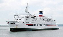
The Coopérative de Transport Maritime et Aérien (Groupe C.T.M.A.) operates a ferry service between terminals in Souris, Prince Edward Island, and Cap-aux-Meules.
The Société des traversiers du Québec (STQ), under an agreement with Coopérative de Transport Maritime et Aérien (Groupe C.T.M.A.), transports goods year-round.
In summer the STQ offers an 8-day round-trip cruise from Port of Montreal to the Port of Cap-aux-Meules. This service has been on hold between 2020 and 2023.
Road
Main article: Quebec Route 199
Quebec Route 199 is an essential link for the municipality of Îles-de-la-Madeleine.
In April 2023, Geneviève Guilbault, Quebec's Minister of Transport and Sustainable Mobility (Transports Québec) announced the start of work to protect Highway 199, which will protect the road from coastal hazards and limit the consequences of coastal erosion and submersion on road network infrastructure. According to the Minister, the work demonstrates the government's willingness to innovate in the context of climate change.
Air
Main article: Îles-de-la-Madeleine Airport
Îles-de-la-Madeleine Airport is located at Havre-aux-Maisons. The airport operates flights across the archipelago as well as to Montreal, Quebec City and Gaspé and seasonally, to the French overseas collectivity of Saint-Pierre and Miquelon.
Photos
- Here and there
-
 Havre-Aubert
-
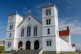 Saint-François-Xavier Church in Bassin
-
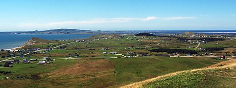 Havre-aux-Maisons
-
 Borgot lighthouse in L'Étang-du-Nord
-
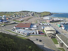 Grindstone (Cap-aux-Meules)
See also
References
- "Les Îles-de-la-Madeleine". Geographical Names Data Base. Natural Resources Canada.
- ^ "Répertoire des municipalités: Geographic code 01023". www.mamh.gouv.qc.ca (in French). Ministère des Affaires municipales et de l'Habitation.
- ^ "Census Profile, 2021 Census Les Îles-de-la-Madeleine, Municipalité [Census subdivision], Quebec". Statistics Canada. Retrieved July 18, 2024.
- "Concerning the agglomeration of Îles-de-la-Madeleine" (PDF). Gazette officielle du Québec. Government of Quebec Affaires municipales. 2005-12-07. p. 9. Retrieved 4 March 2024.
The purpose of this Order is to supplement, for the agglomeration of Îles-de-la-Madeleine, the rules prescribed by the Act respecting the exercise of certain municipal powers
- ^ "Les Îles-de-la-Madeleine". Commission de toponymie Quebec (in French). Government of Quebec. 2002-01-24. Retrieved 4 March 2024.
On January 1, 2002, the municipality of Îles-de-la-Madeleine was created.
- David B. Quinn; Jacques Rousseau (1966). "Amerindian Place Names of Canada The Old English Travellers, 1591-1602" (PDF) (in English and French). Département de géographie de l'Université Laval. pp. 2, 5 of 16. Retrieved 17 March 2024.
The Principal Navigations in 1600 give names: Menquit for the Magdalen Islands, and Natiscotec for Anticosti. I
- Noel Falaise (1950-06-01). "The Magdalen Islands under the French regime" (PDF). Érudit (in French). Revue d'histoire de l'Amérique française. p. 13. Retrieved 11 March 2024.
The French fishermen therefore moved their fishing grounds back to the Magdalen Islands, where, improvising as walrus and seal hunters, they encountered the Micmacs.
- Martijn, Charles (2003). "Early Mikmaq Presence in Southern Newfoundland: An Ethnohistorical Perspective, c.1500-1763". Newfoundland and Labrador Studies. 19 (1): 44–102. ISSN 1715-1430. Retrieved 2012-04-29.
- Jean-François Rail (2009). "Seabirds and Colonial Waterbirds of the Magdalen Islands" (PDF). Canadian Wildlife Service. Environnement Canada, Canadian Wildlife Service. p. 74.
community of seabirds that can be found nesting in the numerous and characteristic red sandstone cliffs, as well as on sandy islands in lagoons and rocky offshore islands
- Michel Bideaux, Université Paul-Valéry Montpellier (1986). "Jacques Cartier relations 1534". Bibliothèque et Archives nationales du Québec. Bibliothéque du Nouveau Monde. p. 499. Retrieved 18 March 2024.
Cartier's first voyage was troubled only by headwinds and storms that slowed it down until the voyage took three long months.
- Peterson, Mark. The Rise and Fall of an Atlantic Power, 1630–1865, The City-State of Boston. Princeton University Press, 2019, page 16.
- "Les îles de la Madeleine" (PDF). Quebec Gouvernement. Ministère de l'Énergie et des Ressources naturelles. 2020-01-27. pp. 8 of 66. Retrieved 21 March 2024.
The first real settlers to settle on the islands came after the fall of Louisbourg and the dispersal of the Acadians from the Grand-Pré region of Acadia
- "Les îles de la Madeleine". Commission de toponymie Quebec (in French). Government of Quebec. 1968-12-05. Retrieved 29 February 2024.
In 1534, Jacques Cartier explored the islands and left the first certain evidence of European visits to the archipelago
- "Anse-à-la-Cabane lighthouse". Commission de toponymie Quebec (in French). Government of Quebec. 2017-05-26. Retrieved 7 March 2024.
Built in 1870 and 1871, it was erected during the first wave of lighthouse construction to make navigation safe in the Gulf of St. Lawrence
- Anna Bressanin; Anne Banas (2022-02-24). "A tempestuous isle of 1,000 shipwrecks". BBC. Retrieved 21 March 2024.
Between 500 and 1,000 shipwrecks were recorded around Quebec's isolated Magdalen Islands – and the descendants of the resilient survivors live to tell their stories.
- "Installation of the first submarine cable with the mainland,1880". Centre d'archives régional des Iles (in French). 2015-08-01. Retrieved 22 March 2024.
1880, août éphémérides, câble télégraphique, Clarke , communications , Lebourdais
- Patricia Bufe (2020). "A Letter to the Sea - ponchon" (PDF). erudit.org (in French). p. 4. Retrieved 21 March 2024.
In January 1910, Magdalen Islanders cut off from the world threw a barrel into the sea containing about twenty letters.
- "Cégep de la Gaspésie et des Îles - Campus des Îles-de-la-Madeleine". Infoway FPT - Vocational and Technical Training in Quebec. 2024. Retrieved 14 March 2024.
Compétences Québec, in partnership with the Government of Quebec
- C, Plourde (2009-09-19). "Small Buildings" (PDF). Quebec Museum of Popular Culture. Retrieved 6 March 2024.
The deportation of the Acadians is credited with this Dutch contribution to Quebec architecture.
- Jean-charles Fortin; Paul Larocque (2003). "Histoire des Îles-de-la-Madeleine". Bibliothèque et Archives nationales du Québec (in French). Institut québécois de recherche sur la culture. pp. 42, 84 of 407. Retrieved 12 March 2024.
In areas subject to the influence of the tides, the herbaceous vegetation has a maritime character (salt meadows).
- "Prince Edward Island / Îles de la Madeleine ferry". Traversier CTMA. 2024. Retrieved 29 March 2024.
Access the Îles de la Madeleine through this five hours crossing between Prince Edward Island and the Madelinot archipelago
- "Grande-Entrée (Municipalité)". Commission de toponymie Quebec. Government of Quebec. 2002-01-24. Retrieved 8 March 2024.
Adjacent to the village municipality of Grosse-Île in the Magdalen Islands, this municipality was officially established in 1929
- "2021 Community Profiles". 2021 Canadian census. Statistics Canada. February 4, 2022. Retrieved 2023-10-19.
- "2016 Community Profiles". 2016 Canadian census. Statistics Canada. August 12, 2021. Retrieved 2019-11-29.
- "2011 Community Profiles". 2011 Canadian census. Statistics Canada. March 21, 2019. Retrieved 2014-02-23.
- "2006 Community Profiles". 2006 Canadian census. Statistics Canada. August 20, 2019.
- "2001 Community Profiles". 2001 Canadian census. Statistics Canada. July 18, 2021.
- ^ "Census Profile, 2016 Census Les Îles-de-la-Madeleine, Municipalité [Census subdivision], Quebec". Statistics Canada. Retrieved November 29, 2019.
- ^ Statistics Canada: 1996, 2001, 2006, 2011, 2016, 2021 census
- Chantal Naud (2013-03-09). "The Language of the Magdalen Islands" (PDF). Dictionary of the Regionalisms of the Magdalen Islands. p. 6. Retrieved 9 March 2024.
In the Islands, the wind from the open sea willingly sweeps away prejudices and one discovers complete freedom of speech
- "Site patrimonial de La Grave" (in French). Répertoire du patrimoine culturel du Québec. 2019. Retrieved 9 March 2024.
During the 16th century, the area was frequented by indigenous groups from the mainland and Basque, Breton and Norman fishermen
- "Îles-de-la-Madeleine Cultural Policy" (PDF) (in French). Ministère de la Culture et des Communications du Québec. 2002-11-06. p. 21. Retrieved 9 March 2024.
Magdalen Island culture draws its colours from these melting pots of identity and from its maritime and island environment
- Stéphanie Arseneau Bussière; Hélène Chevrier (2012-02-08). "Socio-economic profile of the Magdalen Islands' English-speaking community" (PDF). Centre de recherche sur les milieux insulaires et maritimes (CERMIM). pp. 12 of 90. Retrieved 28 March 2024.
Merchants, also mostly English-speaking, prefer to be near their markets (the harbours) and even more so their customers,
- "Prince Edward Island / Îles de la Madeleine FERRY". Traversier CTMA. 2024. Retrieved 3 March 2024.
Access the Îles de la Madeleine through this five hours crossing between Prince Edward Island and the Madelinot archipelago
- ^ "Launch of work to protect Highway 199 in the Pointe-aux-Loups sector". Transport et Mobilité durable Québec. 2023-03-19. Retrieved 31 March 2024.
A storage site for dredged sands, including a sedimentation pond for dredged water, will be developed.
- "Route 199 et chemins. maps" (PDF) (in French). Le directeur général des élections du Québec. March 2017. Retrieved 31 March 2024.
L'Île du Havre-Aubert, L'Île d'Entrée, Fatima, Grosse Île
External links
| Adjacent municipal subdivisions | ||||||||||||||||
|---|---|---|---|---|---|---|---|---|---|---|---|---|---|---|---|---|
| ||||||||||||||||
| Regional county municipalities and equivalent territories | |
|---|---|
| Municipalities | |
| Administrative divisions of Quebec | |
| Magdalen Islands | |||||
|---|---|---|---|---|---|
| Islands |  | ||||
| Localities |
| ||||
| Politics | |||||