Unincorporated community in Colorado, United States
| Liggett, Colorado | |
|---|---|
| Unincorporated community | |
| Country | United States |
| State | Colorado |
| County | Boulder |
| Elevation | 5,007 ft (1,526 m) |
| Time zone | UTC-7 (Mountain (MST)) |
| • Summer (DST) | UTC-6 (MDT) |
| Area code | 720 |
| GNIS feature ID | 178727 |
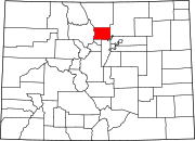
Liggett is an unincorporated community in Boulder County, Colorado, United States. It is to the northwest of Lafayette.
Description
Liggett is mostly rural grassland, with a few buildings. Nearby are two lakes, Boulder Creek, and a former Union Pacific rail line currently owned by the Regional Transportation District. Directly to the west of Liggett is 95th Street, heading south to Lafayette and north to Longmont. A second road, Valmont Road, terminates at 95th Street and heads west to Boulder.
The post office in Boulder serves Liggett addresses.
History
Liggett was established prior to 1904, and was originally known as White Rock. The name was changed to Liggett sometime between 1945 and 1957. The railway was built through the area in the early 1870s by the Denver & Boulder Valley Railroad, and connected Boulder to Brighton.
The rail line was acquired by the Union Pacific Railroad via a merger in 1898, and later bought by the Regional Transportation District in 2009.
Name
The origin is not known for certain, but the community is possibly named after Liggett, Indiana.
References
- ^ "Liggett, Colorado". Geographic Names Information System. United States Geological Survey, United States Department of the Interior.
- "United States Zip Codes". Retrieved September 8, 2021.
- United States Geological Survey (1904–1957). Niwot Quadrangle, Colorado (Map). United States Department of the Interior. Retrieved September 8, 2021.
- Fraser, Clayton, B. (August 31, 1997), The History and Evolution of Colorado's Railroads: 1858–1948 (PDF), Loveland: United States Department of the Interior, p. 101
{{citation}}: CS1 maint: multiple names: authors list (link) - North Metro Corridor – Final Environmental Impact Statement and Final Section 4(f) Evaluation – Executive Summary (PDF), Regional Transportation District, January 2010, p. 6
| Municipalities and communities of Boulder County, Colorado, United States | ||
|---|---|---|
| County seat: Boulder | ||
| Cities |  | |
| Towns | ||
| CDPs | ||
| Unincorporated communities | ||
| Ghost town | ||
| Footnotes | ‡This populated place also has portions in an adjacent county or counties | |
40°02′42″N 105°08′02″W / 40.04500°N 105.13389°W / 40.04500; -105.13389
Categories: