| Lingwala | |
|---|---|
| Commune | |
| Commune de Lingwala | |
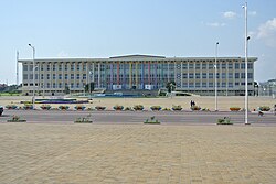
 Parliament building Parliament building | |
| Show city centerShow street mapShow city-provinceLingwala on map of Kinshasa city-province | |
 Kinshasa city-province on map of DR Congo Kinshasa city-province on map of DR Congo | |
| Coordinates: 04°19′13″S 15°17′54″E / 4.32028°S 15.29833°E / -4.32028; 15.29833 | |
| Country | |
| City-Province | Kinshasa |
| Area | |
| • Total | 2.88 km (1.11 sq mi) |
| Population | |
| • Total | 94,635 |
| • Density | 33,000/km (85,000/sq mi) |
Lingwala is a municipality (commune) in the Lukunga district of Kinshasa, the capital city of the Democratic Republic of the Congo.
It is situated in northern Kinshasa, south of Gombe and Boulevard du 30 Juin.
Demographics
| Year | 1967 | 1970 | 1984 | 2003 | 2004 |
|---|---|---|---|---|---|
| Population | 37,240 | 46,209 | 49,173 | 91,520 | 94,635 |
References
- "Lingwala, Kinshasa, Democratic Republic of the Congo". Google Maps. Retrieved 20 August 2011.
- "Géographie de Kinshasa (Geography of Kinshasa)" (in French). Ville de Kinshasa (City of Kinshasa). Archived from the original on 23 July 2012. Retrieved 20 August 2011.
See also
| Communes of the city-province of Kinshasa | ||
|---|---|---|
| Funa District | ||
| Lukunga District | ||
| Mont Amba District | ||
| Tshangu District | ||
This Democratic Republic of the Congo location article is a stub. You can help Misplaced Pages by expanding it. |