Misplaced Pages

List of Nova Scotia provincial highways

Article snapshot taken from Wikipedia with creative commons attribution-sharealike license. Give it a read and then ask your questions in the chat. We can research this topic together.
(Redirected from List of highways in Nova Scotia)

Nova Scotia provincial highway system
Standard highway markers for Nova Scotia
Highway names
Arterial (100-series) highwaysNova Scotia Highway 1XX (Hwy 1XX)
Trunk HighwaysNova Scotia Trunk XX (Trunk XX)
Collector HighwaysNova Scotia Route XXX (Route XXX)
System links

This is a list of numbered highways in the province of Nova Scotia.

Arterial (100-series) highways

Main article: 100-series highways (Nova Scotia)

A 100-series highway is a designation applied to a highway that can be a controlled-access expressway, Super-2, or fully divided freeway. The designation can also be applied in some cases to sections of uncontrolled access roads which are deemed strategically important and which will be upgraded in the future to controlled-access.

Trunk Highways

Nova Scotia's original arterial highway number system had route number signs in the same shape as the U.S. Highway route number signs. These signs are now used for Trunk routes. Former, "missing", Trunk routes were largely downgraded to Collector Routes in 1969.

Number Length (km) Length (mi) Southern or western terminus Northern or eastern terminus Local names Formed Removed Notes
Trunk 1 327.5 203.5 Yarmouth Ferry Terminal in Yarmouth Trunk 2 in Bedford Evangeline Trail Passes through Lower Sackville, Windsor, the Annapolis Valley, and Digby.
Trunk 2 266.0 165.3 Hwy 102 in Halifax Hwy 104 (TCH) in Fort Lawrence Passes through Bedford, Lower Sackville, Truro, Parrsboro, and Amherst.
Trunk 2A 23 14 Trunk 2 in Southampton Trunk 2 in Upper Nappan Former section of Trunk 2; replaced by Route 302.
Trunk 3 291.3 181.0 Trunk 1 in Yarmouth Halifax Passes through Liverpool, Bridgewater, and Lunenburg.
Trunk 3A 15 9.3 Trunk 3 in Bridgewater Trunk 3 in Mahone Bay Deviation of Trunk 3 that completely circumvents the First and Kingsburg Peninsulas to go directly between Mahone Bay and Bridgewater. Replaced by Route 325 and rendered partly obsolete by Highway 103.
Trunk 4 414.6 257.6 Hwy 104 (TCH) near Thomson Station Trunk 28 in Glace Bay Passes through Truro, New Glasgow, Antigonish, and Sydney. Largely unsigned near Truro, possibly to lure traffic onto the superseding highway.
Trunk 5 165 103 Trunk 4 / Trunk 19 in Port Hastings Sydney Replaced by Hwy 105, with some bypassed sections re-designated as Route 205 and Route 305 or as unnumbered, local roads.
Trunk 6 136.4 84.8 Hwy 104 (TCH) in Amherst Hwy 106 (TCH) in Pictou
Trunk 7 278.2 172.9 Trunk 2 in Bedford Trunk 4 in Antigonish Passes through Dartmouth, Musquodoboit Harbour, and Sheet Harbour.
Trunk 8 112.9 70.2 Trunk 3 in Liverpool Trunk 1 in Annapolis Royal Kejimkujik Scenic Drive Connects to Kejimkujik National Park.
Trunk 9 59 37 Apple River Trunk 2 in Parrsboro Replaced by Route 209.
Trunk 10 88.2 54.8 Route 325 in Bridgewater Trunk 1 in Middleton
Trunk 11 49 30 Trunk 4 in Truro Trunk 6 in Tatamagouche Replaced by Route 311.
Trunk 12 65.6 40.8 Trunk 3 in Chester Basin Trunk 1 in Kentville
Trunk 14 120.7 75.0 Trunk 3 near Chester Trunk 2 in Milford Station Passes through Windsor.
Trunk 15 120.0 74.6 Trunk 4 in Newport Corner Trunk 2 in Shubenacadie Replaced by Route 215.
Trunk 16 79.2 49.2 Trunk 4 in Monastery Canso
Trunk 17 64 40 Trunk 1 in Digby Westport, Brier Island Replaced by Route 217.
Trunk 18 11 6.8 Trunk 7 in Dartmouth Trunk 2 in Waverley Replaced by Route 318.
Trunk 19 106.6 66.2 Hwy 104 (TCH) / Hwy 105 (TCH) / Trunk 4 in Port Hastings Cabot Trail at Margaree Forks Ceilidh Trail
Trunk 19 85 53 Trunk 5 in Port Hastings Trunk 5 in Baddeck 01940-01-011940s Trunk 5 and Trunk 19 designations were switched between Port Hastings and Baddeck.
Trunk 20 56 35 Trunk 7 at Melrose Trunk 4 in Antigonish 01940-01-011940s Replaced by Trunk 7; proposed section of Trunk 7 between Melrose and Trunk 16 was not constructed.
Trunk 20 2 1.2 Trunk 4 at Grande Anse Louisdale Replaced by Route 320; Route 320 was subsequently relocated with the completion of Hwy 104.
Trunk 21 38 24 Trunk 4 in Oxford Trunk 6 in Port Philip Replaced by Route 321.
Trunk 22 35.6 22.1 Trunk 4 in Sydney Louisbourg Mira Road
Trunk 23 72 45 Trunk 5 at Aberdeen Trunk 5 at Leitches Creek Station Replaced by Route 223.
Trunk 26 Trunk 2 in Athol Springhill 01938-01-011938 Section between Springhill and Little Forks was replaced by Trunk 2, the remainder was decommissioned as is known as Little Forks Road; bypassed section of Trunk 2 was replaced by Route 302.
Trunk 28 35.6 22.1 Trunk 4 in Sydney Trunk 4 / Route 255 in Glace Bay
Trunk 30 298 185 Hwy 105 (TCH) at South Haven Hwy 105 (TCH) at Buckwheat Corner Cabot Trail Trunk 30 is unsigned; Passes through Cape Breton Highlands National Park.
Trunk 30 17 11 Trunk 3 in Barrington Passage Lower Clarks Harbour, Cape Sable Island Replaced by Route 330.
Trunk 31 56 35 Trunk 3 in Mill Village Trunk 3 in Bridgewater Replaced by Route 331.
Trunk 32 4.6 2.9 Route 306 in Halifax Main Avenue in Halifax • Dunbrack Street
• North West Arm Drive (former)
Trunk 32 is unsigned.
Trunk 32 36 22 Trunk 3 in Upper LaHave Trunk 3 in Lunenburg Replaced by Route 332.
Trunk 33 4.7 2.9 Hwy 101 / Trunk 1 in Lower Sackville Trunk 7 in Bedford Bedford Bypass Trunk 33 is unsigned.
Trunk 33 63 39 Trunk 3 in Upper Tantallon Trunk 3 in Beechville Replaced by Route 333.
Trunk 34 20 12 Lower Wedgeport Trunk 3 in Arcadia Replaced by Route 334.
Trunk 35 14 8.7 Lower West Pubnico Trunk 3 in Pubnico Replaced by Route 335.
Trunk 40 80 50 Trunk 1 in Hebron Trunk 1 in Weymouth Replaced by Route 340.
Trunk 41 19 12 Trunk 1 in Kentville Kingsport Replaced by Route 341 (Kentville – Canard), Route 358 (Canard – Canning), and Route 221 (Canning – Kingsport).
Trunk 44 6 3.7 Mulgrave Trunk 4 in Aulds Cove 01955-01-011955 01970-01-011970 Former Trunk 4 to Mulgrave–Port Hawkesbury ferry (ferry replaced by Canso Causeway); replaced by Route 344.
Trunk 45 63 39 Trunk 4 in Sutherlands River Trunk 4 / Trunk 7 in Antigonish Replaced by Route 245.
Trunk 66 47 29 Trunk 6 in East Amherst Trunk 6 in Port Howe Replaced by Route 366.
  •       Former

Collector Highways

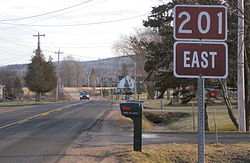
View of Route 201 outside of Bridgetown.
Start of Route 256 in West New Annan.
Start of Route 311 in Tatamagouche.
Route 326 near the junction with Trunk 6.
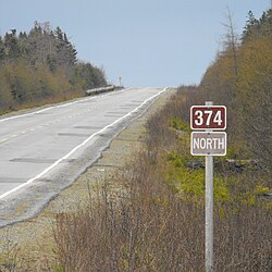
Route 374 in Malay Falls.
Highway Length (km) Length (mi) Destinations Notes
Route 201 38 24 Annapolis Royal - Bridgetown - Lawrencetown - Middleton - Greenwood - Kingston
Route 202 38 24 Mount Uniacke - Upper Rawdon - Nine Mile River
Route 203 83 52 Carleton - Welshtown - Shelburne
Route 204 54 34 Amherst - Salem - Streets Ridge
Route 205 9 5.6 Baddeck - MacAulays Hill
Route 206 12 7.5 Arichat - West Arichat - Martinique
Route 207 39 24 Dartmouth - Cole Harbour - Upper Lawerencetown - West Lawerencetown - Lawerencetown - Porters Lake
Route 208 38 24 South Brookfield - Colpton - Nineveh - New Germany
Route 209 98 61 Parrsboro - Advocate Harbour - Joggins
Route 210 32 20 Greenfield - Chelsea - Newcombville
Route 211 35 22 Isaac's Harbour North - Stormont II (Country Harbour Ferry) - Port Bickerton - Stillwater
Route 212 31 19 Halifax Stanfield International Airport - Goffs - Elderbank
Route 213 22 14 Upper Tantallon - Hammonds Plains - Bedford
Route 214 10 6.2 Elmsdale - Belnan - Lower Nine Mile River
Route 215 120 75 Newport Corner - Noel - Maitland - Shubenacadie
Route 216 42 26 Christmas Island - Eskasoni - East Bay
Route 217 64 40 Freeport - East Ferry - Tiddville - Digby
Route 219 20 12 Dunvegan - Margaree Harbour
Route 221 63 39 Kingsport - Canning - Centreville- Spa Springs
Route 223 72 45 North Side Whycocomagh Bay - Grand Narrows - Christmas Island - Leitches Creek Station
Route 224 96 60 Shubenacadie - Gays River - Middle Musquodoboit - Upper Musquodoboit - Sheet Harbour
Route 236 77 48 Scotch Village - Kennetcook - Green Oaks - Truro
Route 239 14 8.7 North West Arm - Edwardsville - Westmount
Route 242 16 9.9 Joggins - River Hebert - Maccan
Route 245 63 39 Sutherlands River - Malignant Cove - Antigonish
Route 246 25 16 Wentworth - West New Annan - Tatamagouche
Route 247 11 6.8 St. Peters - Grand River - Lower L'Ardoise
Route 252 28 17 Mabou - Skye Glen - Whycocomagh
Route 253 12 7.5 Armdale - Purcell's Cove - Herring Cove
Route 255 35 22 Glace Bay - Mira Gut - Hornes Road
Route 256 49 30 West New Annan - The Falls - River John - Lyons Brook
Route 276 5 3.1 South Lochaber - Goshen
Route 277 15 9.3 Lantz - Dutch Settlement - Gays River
Route 289 98 61 Green Oaks - Brookfield - Middle Stewiacke - Upper Stewiacke - Lansdowne - Westville - New Glasgow - Little Harbour
Route 301 17 11 Oxford - Kolbec - Port Howe
Route 302 23 14 Southampton - Athol - Maccan - Nappan
Route 303 11 6.8 Conway - Digby - Digby Ferry
Route 304 10 6.2 Yarmouth, Yarmouth Bar, Cape Forchu, Yarmouth Light
Route 305 27 17 Boularderie East - North Sydney - Sydney - Sydney Mines
Route 306 19 12 Spryfield - Harrietsfield - Williamswood - Sambro
Route 307 19 12 Wentworth Centre via Wentworth Valley - Six Mile Road - Wallace Station - Wallace
Route 308 45 28 Morris Island - Surette's Island - Amiraults Hill - Tusket - Quinan
Route 309 29 18 Barrington - Eel Bay - Clyde River
Route 311 49 30 Truro - North River - Nuttby - Earltown - Tatamagouche
Route 312 13 8.1 South Haven - Englishtown - River Bennet
Route 316 132 82 Half Island Cove - Larry's River - Goldboro - Cross Roads Country Harbour - Goshen - Frasers Mills - St. Andrews - Lower South River
Route 318 11 6.8 Dartmouth - Port Wallace - Portobello - Waverley
Route 320 23 14 Arichat - Martinique - Lennox Passage - Louisdale
Route 321 38 24 Springhill - River Philip - Oxford - Kolbec - Port Howe
Route 322 22 14 Dartmouth - Woodside - Shearwater - Eastern Passage - Cole Harbour
Route 324 11 6.8 Lunenburg - Fauxburg - Blockhouse
Route 325 46 29 Colpton - Wileville - Bridgewater - Maitland - Blockhouse - Mahone Bay
Route 326 19 12 Earltown - Denmark - Brule Corner
Route 327 44 27 Gabarus - Big Ridge - Marion Bridge - Membertou - Sydney
Route 328 3 1.9 Upper Lawrencetown - Lake Major
Route 329 42 26 East River - Bayswater - Northwest Cove - Mill Cove - Hubbards
Route 330 17 11 Cape Sable Island - Clarks Harbour - Barrington Passage
Route 331 57 35 East Port Medway - Petite Riviere - Dublin Shore - LaHave - Pleasantville - Bridgewater
Route 332 37 23 Upper LaHave - Riverport - Lunenburg
Route 333 63 39 Beechville - Hatchet Lake - Peggys Cove - Upper Tantallon
Route 334 20 12 Lower Wedgeport - Arcadia
Route 335 14 8.7 Lower West Pubnico - Pubnico
Route 336 23 14 Upper Musquodoboit - Dean - Springside
Route 337 52 32 Antigonish - Cape George - Malignant Cove
Route 340 80 50 Hebron - Carleton - Pleasant Valley - Weymouth
Route 341 10 6.2 Kentville - Canard
Route 344 47 29 Auld's Cove - Mulgrave - Sand Point - St. Francis Harbour - Boylston
Route 347 66 41 New Glasgow - Priestville - Garden of Eden - Aspen
Route 348 101 63 Little Harbour - Pictou Landing - Trenton - New Glasgow - Glenelg - Melrose
Route 349 25 16 Armdale - Spryfield - Herring Cove - Sambro
Route 354 70 43 Middle Sackville - Beaver Bank - Upper Rawdon - Gore - Kennetcook - Noel
Route 357 39 24 Musquodoboit Harbour - Meaghers Grant - Elderbank - Middle Musquodoboit
Route 358 30 19 Greenwich - Canard - Canning - The Lookoff - Scot's Bay
Route 359 16 9.9 Kentville - Aldershot - Centreville - Halls Harbour
Route 360 22 14 Morristown - Berwick - Welsford - Harbourville
Route 362 47 29 Middleton - Spa Springs - Margaretsville - East Margaretsville
Route 366 47 29 East Amherst - Tidnish Bridge - Lorneville - Northport - Port Howe
Route 368 17 11 Mahoneys Corner - Streets Ridge - Middleboro - Head of Wallace Bay
Route 374 86 53 New Glasgow - Stellarton - Lorne - Trafalgar - Sheet Harbour
Route 376 17 11 West River - Haliburton
Route 395 37 23 Southwest Margaree - Upper Margaree - Ainslie Glen - Churchview

Scenic Routes

Name Length (km) Length (mi) Southern or western terminus Northern or eastern terminus Component highways Opened Removed Notes
Bras d'Or Lakes Scenic Drive 417 259 Tourist loop around Bras d'Or Lake Current
Cabot Trail 298 185 Hwy 105 at South Haven Hwy 105 at Buckwheat Corner Current
Ceilidh Trail 112 70 Hwy 104 / Hwy 105 / Trunk 4 in Port Hastings Cabot Trail in Margaree Harbour Current
Digby Neck and Islands Scenic Drive 64 40 Route 217 in Digby Westport, Brier Island Route 217 Current
Evangeline Trail 292 181 Hwy 101 / Hwy 102 in Bedford Trunk 3 in Yarmouth Current
Fleur-de-lis Trail 217 135 Hwy 104 / Hwy 105 / Trunk 19 in Port Hastings Louisbourg Current 35 km (22 mi) spur to Isle Madame.
Fundy Shore Ecotour 360 224 Trunk 2 at Upper Nappan Trunk 14 in Brooklyn Former
Fundy Shore Scenic Drive 128 80 Trunk 2 at Upper Nappan Trunk 2 at Parrsboro Current
Glooscap Trail 357 222 Hwy 104 in Fort Lawrence Scot's Bay Current 59 km (37 mi) spur between Truro and Enfield.
Kejimkujik Scenic Drive 113 70 Trunk 3 in Liverpool Trunk 1 in Annapolis Royal Trunk 8 Current
Lighthouse Route 585 364 Trunk 1 in Yarmouth Trunk 3 in Halifax Current
Marconi Trail 63 39 Louisbourg Trunk 4 / Trunk 28 in Glace Bay Current
Marine Drive 414 257 Dartmouth Hwy 104 / Trunk 4 at Aulds Cove Current 16 km (10 mi) spur to Canso.
Sunrise Trail 333 207 Hwy 104 in Amherst Canso Causeway Current

References

  1. ^ Department of Highways, Nova Scotia (1936). Highway Map Nova Scotia (Map). Province of Nova Scotia.
  2. ^ Department of Highways, Nova Scotia (1938). Highway Map Nova Scotia (Map). Province of Nova Scotia.
  3. Imperial Oil (1940). Imperial Oil map of Eastern Canada (Map). Imperial Oil Ltd.
  4. ^ Province of Nova Scotia (1944). Official Road Map (Map). Province of Nova Scotia, Canada's Ocean Playground.
  5. Surveys and Mapping Branch, Department of Mines and Technical Surveys (1966). "Highways of Canada and Northern United States - Eastern Sheet" (Map). Canada and Northern United States. 1 in = 150 mi. Ottawa: Canadian Government Travel Bureau.
Roads and highways in Nova Scotia
100-series
Trunk routes
Collector roads
Scenic routes
Provincial and territorial highways in Canada
Categories: