Misplaced Pages

List of tallest structures in Prague

Article snapshot taken from Wikipedia with creative commons attribution-sharealike license. Give it a read and then ask your questions in the chat. We can research this topic together.

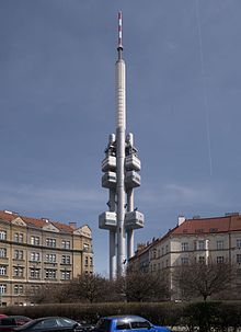
Žižkov Television Tower, tallest structure in Prague
Chimney of Malešice Incineration Plant, tallest chimney in Prague

This lists ranks the tallest structures in Prague that stand at least 96.5 metres (317 ft) tall. The list contains all types of structures.

Name Pinnacle height Year Structure type Coordinates
Žižkov Television Tower 216 m 1992 Freestanding tower 50°4′51″N 14°27′4″E / 50.08083°N 14.45111°E / 50.08083; 14.45111 (Žižkov Television Tower)
Chimney of Malešice Incineration Plant 180 m 1996 Chimney 50°4′44″N 14°32′28″E / 50.07889°N 14.54111°E / 50.07889; 14.54111 (Chimney of Malešice Incineration Plant)
Chimney of Malešice Heating Power Plant 160 m 1961 Chimney 50°5′5″N 14°31′27″E / 50.08472°N 14.52417°E / 50.08472; 14.52417 (Chimney of Malešice Heating Power Plant)
Chimney of Třeboradice Heating Power Plant 150 m ? Chimney 50°9′53″N 14°30′52″E / 50.16472°N 14.51444°E / 50.16472; 14.51444 (Chimney of Třeboradice Heating Power Plant)
Chimney of Michle Heating Plant 140 m ? Chimney 50°3′15″N 14°28′8″E / 50.05417°N 14.46889°E / 50.05417; 14.46889 (Chimney of Michle Heating Plant)
Chimney of Michle Heating Plant 120 m ? Chimney 50°3′15″N 14°28′11″E / 50.05417°N 14.46972°E / 50.05417; 14.46972 (Chimney of Michle Heating Plant)
Chimney of Motorlet Jinonice 115 m 1984 Chimney 50°3′20″N 14°22′46″E / 50.05556°N 14.37944°E / 50.05556; 14.37944 (Chimney of Motorlet Jinonice)
Chimney of Průmstav 110 m ? Chimney 50°2′40″N 14°34′26″E / 50.04444°N 14.57389°E / 50.04444; 14.57389 (Chimney of Průmstav)
Chimney of Státní statek Radotín 110 m ? Chimney 49°59′24″N 14°22′35″E / 49.99000°N 14.37639°E / 49.99000; 14.37639 (Státní statek Radotín)
City Tower 109 m 2008 Skyscraper 50°3′1″N 14°26′10″E / 50.05028°N 14.43611°E / 50.05028; 14.43611 (City Tower)
City Empiria 104 m 1977 Skyscraper 50°3′0″N 14°26′22″E / 50.05000°N 14.43944°E / 50.05000; 14.43944 (City Empiria)
V Tower 103.9 m 2017 Skyscraper 50°2′57″N 14°26′11″E / 50.04917°N 14.43639°E / 50.04917; 14.43639 (V Tower)
Chimney of Holešovice Heating Power Plant 100 m ? Chimney 50°6′36″N 14°26′10″E / 50.11000°N 14.43611°E / 50.11000; 14.43611 (Chimney of Holešovice Heating Power Plant)
Main tower of St. Vitus Cathedral 96.5 m 1929 Church tower 50°5′27″N 14°24′2″E / 50.09083°N 14.40056°E / 50.09083; 14.40056 (Main tower of St. Vitus Cathedral)

References

Map all coordinates using OpenStreetMap

Download coordinates as:

  1. koda: RU M 150/4 Teplárna Třeboradice, Za Tratí, Praha 9 - Třeboradice
  2. "KODA - karta komína: RU120/4 Teplárna Michle, Chodovská, Praha 4 - Michle (#0044)".
  3. koda: RU M 115/1/2 Motorlet, Radlická, Praha 5 - Jinonice
  4. "KODA - karta komína: RU110/2 Průmstav, Kutnohorská, Praha 10 - Dolní Měcholupy (#0070)".
  5. "KODA - karta komína: RU105/1/2 Státní statek Radotín, Výpadová, Praha 5 - Radotín (#0030)".

See also

Portals: Categories: