Misplaced Pages

Livingstone County, New South Wales

Article snapshot taken from Wikipedia with creative commons attribution-sharealike license. Give it a read and then ask your questions in the chat. We can research this topic together.
(Redirected from Livingstone County)

Map all coordinates using OpenStreetMap

Download coordinates as:

Cadastral in New South Wales, Australia
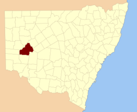
Livingstone
New South Wales
Location in New South Wales
Lands administrative divisions around Livingstone:
Tandora Young Werunda
Menindee Livingstone Woore
Windeyer Perry Manara

Livingstone County is one of the 141 cadastral divisions of New South Wales. The Darling River is the western and north-western boundary, near Menindee.

Livingstone County was named in honour after the African missionary and explorer David Livingstone (1813-1873).

Parishes within this county

A full list of parishes found within this county; their current LGA and mapping coordinates to the approximate centre of each location is as follows:

Parish LGA Coordinates
Albemarle Central Darling Shire 32°19′13″S 142°39′40″E / 32.32028°S 142.66111°E / -32.32028; 142.66111 (Albemarle)
Arlington Central Darling Shire 32°27′30″S 143°45′32″E / 32.45833°S 143.75889°E / -32.45833; 143.75889 (Arlington)
Ashbourne Central Darling Shire 32°19′46″S 143°23′35″E / 32.32944°S 143.39306°E / -32.32944; 143.39306 (Ashbourne)
Berangabah Central Darling Shire 32°29′45″S 143°31′58″E / 32.49583°S 143.53278°E / -32.49583; 143.53278 (Berangabah)
Billitong Central Darling Shire 32°08′26″S 143°10′52″E / 32.14056°S 143.18111°E / -32.14056; 143.18111 (Billitong)
Bindi Central Darling Shire 32°27′48″S 143°12′01″E / 32.46333°S 143.20028°E / -32.46333; 143.20028 (Bindi)
Blenalben Central Darling Shire 32°22′43″S 143°49′06″E / 32.37861°S 143.81833°E / -32.37861; 143.81833 (Blenalben)
Blenheim Central Darling Shire 32°21′22″S 142°31′28″E / 32.35611°S 142.52444°E / -32.35611; 142.52444 (Blenheim)
Boliva Central Darling Shire 32°38′00″S 142°51′31″E / 32.63333°S 142.85861°E / -32.63333; 142.85861 (Boliva)
Boolaboolka Central Darling Shire 32°36′04″S 143°12′44″E / 32.60111°S 143.21222°E / -32.60111; 143.21222 (Boolaboolka)
Boomery Central Darling Shire 32°16′03″S 143°13′47″E / 32.26750°S 143.22972°E / -32.26750; 143.22972 (Boomery)
Boonditti Central Darling Shire 32°21′29″S 142°56′52″E / 32.35806°S 142.94778°E / -32.35806; 142.94778 (Boonditti)
Boonoona Central Darling Shire 32°38′47″S 143°01′52″E / 32.64639°S 143.03111°E / -32.64639; 143.03111 (Boonoona)
Boothingalla Central Darling Shire 32°11′41″S 143°02′23″E / 32.19472°S 143.03972°E / -32.19472; 143.03972 (Boothingalla)
Brainerd Central Darling Shire 31°59′37″S 143°10′19″E / 31.99361°S 143.17194°E / -31.99361; 143.17194 (Brainerd)
Brunker Central Darling Shire 31°56′48″S 143°04′41″E / 31.94667°S 143.07806°E / -31.94667; 143.07806 (Brunker)
Burndoo Central Darling Shire 32°09′35″S 143°41′52″E / 32.15972°S 143.69778°E / -32.15972; 143.69778 (Burndoo)
Clifford Central Darling Shire 31°52′13″S 143°10′58″E / 31.87028°S 143.18278°E / -31.87028; 143.18278 (Clifford)
Connulpie Central Darling Shire 32°39′58″S 143°22′18″E / 32.66611°S 143.37167°E / -32.66611; 143.37167 (Connulpie)
Conolly Central Darling Shire 32°36′22″S 142°36′31″E / 32.60611°S 142.60861°E / -32.60611; 142.60861 (Conolly)
Coveney Central Darling Shire 32°04′06″S 143°19′15″E / 32.06833°S 143.32083°E / -32.06833; 143.32083 (Coveney)
Cowary Central Darling Shire unknown
Culpaulin Central Darling Shire unknown
Dromore Central Darling Shire 32°23′21″S 143°34′20″E / 32.38917°S 143.57222°E / -32.38917; 143.57222 (Cowary)
Gemini Central Darling Shire 32°24′40″S 142°40′21″E / 32.41111°S 142.67250°E / -32.41111; 142.67250 (Gemini)
Gordon Central Darling Shire 32°25′40″S 142°50′09″E / 32.42778°S 142.83583°E / -32.42778; 142.83583 (Gordon)
Haribel Central Darling Shire 32°00′24″S 143°20′00″E / 32.00667°S 143.33333°E / -32.00667; 143.33333 (Haribel)
Huco Central Darling Shire 32°35′03″S 143°02′22″E / 32.58417°S 143.03944°E / -32.58417; 143.03944 (Huco)
Hudson Central Darling Shire 32°17′53″S 143°44′48″E / 32.29806°S 143.74667°E / -32.29806; 143.74667 (Hudson)
Liddell Central Darling Shire 32°12′38″S 142°43′30″E / 32.21056°S 142.72500°E / -32.21056; 142.72500 (Liddell)
Makingah Central Darling Shire 32°32′52″S 142°37′02″E / 32.54778°S 142.61722°E / -32.54778; 142.61722 (Makingah)
Mandy Central Darling Shire 32°41′50″S 142°45′01″E / 32.69722°S 142.75028°E / -32.69722; 142.75028 (Mandy)
Marlborough Central Darling Shire 31°48′33″S 143°16′31″E / 31.80917°S 143.27528°E / -31.80917; 143.27528 (Marlborough)
Marle Central Darling Shire 32°02′18″S 143°32′31″E / 32.03833°S 143.54194°E / -32.03833; 143.54194 (Marle)
Minden Central Darling Shire 32°09′47″S 143°22′24″E / 32.16306°S 143.37333°E / -32.16306; 143.37333 (Minden)
Mourte Central Darling Shire 32°31′02″S 142°46′30″E / 32.51722°S 142.77500°E / -32.51722; 142.77500 (Mourte)
Mundy Central Darling Shire 32°17′01″S 142°51′56″E / 32.28361°S 142.86556°E / -32.28361; 142.86556 (Mundy)
Newcome Central Darling Shire 32°11′14″S 142°51′16″E / 32.18722°S 142.85444°E / -32.18722; 142.85444 (Newcome)
Pysant Central Darling Shire 32°18′14″S 143°03′13″E / 32.30389°S 143.05361°E / -32.30389; 143.05361 (Pysant)
Repton Central Darling Shire 32°01′13″S 143°01′40″E / 32.02028°S 143.02778°E / -32.02028; 143.02778 (Repton)
Sadlier Central Darling Shire 32°23′27″S 143°03′42″E / 32.39083°S 143.06167°E / -32.39083; 143.06167 (Sadlier)
Steel Central Darling Shire 32°25′11″S 142°30′49″E / 32.41972°S 142.51361°E / -32.41972; 142.51361 (Steel)
Surbiton Central Darling Shire 32°08′45″S 142°53′14″E / 32.14583°S 142.88722°E / -32.14583; 142.88722 (Surbiton)
Talyawalka Central Darling Shire 32°28′57″S 142°27′25″E / 32.48250°S 142.45694°E / -32.48250; 142.45694 (Talyawalka)
Teryawinya Central Darling Shire 32°28′07″S 143°22′21″E / 32.46861°S 143.37250°E / -32.46861; 143.37250 (Teryawinya)
Tintinalogy Central Darling Shire 32°09′12″S 143°02′11″E / 32.15333°S 143.03639°E / -32.15333; 143.03639 (Tintinalogy)
Toorincaca Central Darling Shire 32°32′21″S 142°52′20″E / 32.53917°S 142.87222°E / -32.53917; 142.87222 (Toorincaca)
Undeathi Central Darling Shire 32°31′18″S 142°27′11″E / 32.52167°S 142.45306°E / -32.52167; 142.45306 (Undeathi)
Victoria Central Darling Shire 32°36′24″S 143°24′08″E / 32.60667°S 143.40222°E / -32.60667; 143.40222 (Victoria)
Wambah Central Darling Shire 32°24′38″S 142°25′22″E / 32.41056°S 142.42278°E / -32.41056; 142.42278 (Wambah)
Wanalla Central Darling Shire 32°15′34″S 143°33′20″E / 32.25944°S 143.55556°E / -32.25944; 143.55556 (Wanalla)
Weatherly Central Darling Shire 32°04′56″S 143°09′24″E / 32.08222°S 143.15667°E / -32.08222; 143.15667 (Weatherly)
Widgera Central Darling Shire 32°21′48″S 143°12′55″E / 32.36333°S 143.21528°E / -32.36333; 143.21528 (Widgera)
Yenda Central Darling Shire unknown

References

  1. "Livingstone County". Geographical Names Register (GNR) of NSW. Geographical Names Board of New South Wales. Edit this at Wikidata
Category: