| Lolab Valley | |
|---|---|
| Lolo | |
 Lolab Valley Lolab Valley | |
  | |
| Floor elevation | 5,464 ft (1,665 m) |
| Length | 16 mi (26 km) |
| Width | 3.10 mi (4.99 km) |
| Geography | |
| Country | |
| State | Jammu and Kashmir |
| District | Kupwara |
| Borders on | Kishanganga River| Neelum River (North) Kashmir Valley (South) |
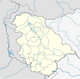
| Coordinates | 34°29′50″N 74°24′45″E / 34.49722°N 74.41250°E / 34.49722; 74.41250 |
| River | Lahwal River |
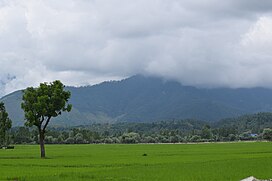
The Lolab Valley, earlier known as Lolo is a Himalayan valley, located in the Kupwara district of the Indian union territory of Jammu and Kashmir. It is named after its founder Mahraja Lolo. Lolab Valley extends from it entrance at Goose Village 1 km (0.62 mi) east of Kupwara to Diver. The valley is an oval-shaped valley 15 miles (26 km) long with an average width of 3.10 miles (5km) that includes three sub-valleys: Kalaroos, Potnai, and Brunai. Valley is at an altitude of 1,590 metres (5,215 ft) above the Sea level. Lolab Valley is characterized by lush green fields, dense forests, and scenic views, making it a popular destination for nature enthusiasts and tourists seeking tranquility.
Geography
The Lolab Valley is situated within the jurisdiction of Sogam Lolab, a Sub-Division of Kupwara. Lolab is sub-district of Kupwara. It is bordered by the Kashmir Valley to the south and the Neelum Valley to the north, and is separated by Nagmarg meadows from Bandipore to the east. It is formed by the flow of Lahwal River, which flows from east to west. The Lolab Valley is home of many ancient springs, and is covered with dense forests of deodar, kair, budul, pine and fir. Fruit trees such as apple, cherry, peach, apricot and walnut are common in the valley, which is known as "the fruit bowl of Jammu and Kashmir". The valley has several natural landmarks and tourist spots, such as the caves of Kalaroos and Green Meadows. The main villages in the Lolab Valley are Saiwan, Surigam, Putushai,Khumriyal, Sogam, Lalpora, Darpora, Cherkoot, Kalaroos, Wavoora, Maidanpora, Shalgund,Khurhama, Warnow, Aafan, Takipora, Cheepora, Goose, etc.
Ecology
Like other valleys in the region, Lolab Valley is also home to many Himalayan wild animals, which include Himalayan black bear, Himalayan brown bear, snow leopard, ibex, markhor, hangul and musk deer. Lolab Valley is adjacent to Kishenganga Valley, and separated by the Line of Control. The Valley has seen many armed combats, which has resulted in the displacement of many wild animals.
Access
The Lolab Valley is well connected by road to Srinagar, the capital of Jammu and Kashmir, and Srinagar Airport. A bus takes (2 hours & 30 minutes) to cover a distance of 114 km (71 mi) and leads through the towns of Sopore and Kupwara. An under-construction road from Bandipora to Lolab via Anderbugh Nagmarg Meadows will cut short the Srinagar-to-Lolab distance by 50 kilometers. In Lolab Valley, there are a few tourist huts and many camping sites. It has the potential to become one of the best tourist destinations in Kashmir.
Tourism
Travelers visiting Lolab sometimes visit the resting place of the saint Kashyap Reshi, which is located at a distance of 1 km from village Lalpora. A spring called Lavnag can be found nearby. The spring is three feet deep and has crystal clear water. Gauri spring is another major spring in the area. Due lack of intervention by government the place has very poor flow of tourists which keeps it potential for tourism still unexplored. This place still manages to be one of the top most camping sites in Kashmir.
Some tourist attractions in the valley include Nagmarg Camping Site kairwan, Satbaran Kalaroos, kalaroos caves, Chandigam, Warnow, Aafan, Machil, Kairwan Anderbugh, Gagal, Doorusa, and some upper forest places like Nagmarg, Trumukhann, Nachyan, Lashkoot, Ibje Pathar, Kimsar.
Poem
Lolab Valley was once visited by the Urdu poet Muhammad Iqbal and he wrote a poem, O Valley of Lolab! in the honour of Lolab's natural environment which starts with:
پانی ترے چشموں کا تڑپتا ہوا سیماب
مرغانِ سحَرتیری فضاؤں میں ہیں بیتاب
اے وادیِ لولاب اے وادیِ لولاب
Your springs and lakes with water pulsating and quivering like quicksilver,
the morning birds fluttering about the sky, agitated and in turmoil,
O Valley of Lolab! O Valley of Lolab!'
گر صاحبِ ہنگامہ نہ ہو منبر ومحراب
دیں بندہٌ مومن کے لیے موت ہے یا خواب
اے وادیِ لولاب اےوادیِ لولاب
When the pulpit and the niche cease to re‐create Resurrections,
faith then is dead or a mere dream, for thee, me and for all.
O Valley of Lolab! O Valley of Lolab!
Notable people
- Shah Faesal - first IAS topper from Kashmir,and bureaucrat
- Anwar Shah Kashmiri - great Islamic scholar of hadith
- Mushtaq Ahmad Lone Cabinet Minister, Politician
- Abdul Haq Khan -cabinet minister
- Ashraf Sehrai - politician, separatist and former chairman and founding member of Tehreek-e-Hurriyat
- Ghulam Nabi Wani - politician
- QAISER JAMSHEED LONE - Politician
See also
References
- S.A. Qazi (2005). Systematic Geography of Jammu and Kashmir. APH Publishing. p. 16–. ISBN 978-8176487863.
- "Lolab | District Kupwara,Government of Jammu & Kashmir | India". Retrieved 27 August 2024.
- John Murray, 1906 (1906). Handbook to India, Burma, and Ceylon. John Murray. p. 253–. ISBN 978-8178350172.
{{cite book}}: CS1 maint: numeric names: authors list (link) - "Loalab Valley on Ikashmir". ikashmir.net. Retrieved 23 June 2012.
- "Fruit bowl of J&K". india9.com. Retrieved 3 July 2012.
- "Nagmarg Camping Cafeteria. · Dever Tekipora Rd, Diver Anderbugh, Jammu and Kashmir 193223". Nagmarg Camping Cafeteria. · Dever Tekipora Rd, Diver Anderbugh, Jammu and Kashmir 193223. Retrieved 21 January 2022.
- Charles Ellison Bates (1980). A gazetteer of Kashmír and the adjacent districts of Kishtwar, Badrawár, Jamu, Naoshera, Punch, and the valley of the Kishen Gang. Light & Life Publishers. p. 26–.
- India Today Volume 25. Thomson Living Media India Ltd., 2000. 2000. pp. 53, 54–. ISBN 978-0674018174.
- Outlook. Vol. 46. Hathway Investments Pvt Ltd. 2006. p. 162.
- Sumantra Bose (2005). Kashmir: Roots of Conflict, Paths to Peace. Harvard University Press. p. 282. ISBN 978-0674018174.
External links
| Kashmir Valley | ||
|---|---|---|
| Passes |  | |
| Valleys | ||
| Cities | ||
| Towns |
| |
| Rivers | ||
| Glaciers | ||
| Lakes | ||
| Mountains | ||
| Hill stations and Mughal gardens | ||
| Protected areas | ||
| See also | ||