| Lookout Summit | |
|---|---|
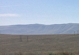
 The summit of Lookout Summit The summit of Lookout Summit | |
| Highest point | |
| Elevation | 3,629 ft (1,106 m) |
| Prominence | 1,829 ft (557 m) |
| Isolation | 12.94 mi (20.82 km) |
| Listing | |
| Coordinates | 46°26′51″N 119°50′24″W / 46.4476327°N 119.8400381°W / 46.4476327; -119.8400381 |
| Geography | |
| Location | Benton County, Washington |
| Parent range | Rattlesnake Hills |
| Topo map | USGS Maiden Spring |
Lookout Summit—officially listed as "Lookout" in the Geographic Names Information System—is the highest point in Benton County, in the U.S. state of Washington. The mountain is also the highest point in the Rattlesnake Hills, with an elevation 98 ft (30 m) higher than the neighboring, more-well-known Rattlesnake Mountain—which is the second highest peak in the range (as well as the county).
 Panorama of Lookout Summit taken from Washington State Route 24.
References
- ^ "Rattlesnake Hills Lookout". Peakbagger.com. Retrieved May 3, 2018.
- ^ "Maiden Spring Topographic Map". United States Geological Survey. Retrieved May 3, 2018.
- ^ "Lookout". Geographic Names Information System. United States Geological Survey, United States Department of the Interior. Retrieved May 3, 2018.
- "Washington County High Points". Peakbagger.com. Retrieved May 3, 2018.
- ^ "Rattlesnake Hills". Peakbagger.com. Retrieved May 3, 2018.
This article related to a mountain, mountain range, or peak in the United States is a stub. You can help Misplaced Pages by expanding it. |