You can help expand this article with text translated from the corresponding article in Serbian. (September 2011) Click for important translation instructions.
|
| Lopatanj Лопатањ | |
|---|---|
| Village (Selo) | |
 | |
| Coordinates: 44°19′N 19°35′E / 44.317°N 19.583°E / 44.317; 19.583 | |
| Country | |
| District | Kolubara |
| Municipality | Osečina |
| Population | |
| • Total | |
| Time zone | UTC+1 (CET) |
| • Summer (DST) | UTC+2 (CEST) |
| Area code | 014 |
Lopatanj is a village located in Osečina Municipality, Kolubara District, Serbia.
-
 Lopatanj - panorama
-
 Lopatanj - panorama
-
 Lopatanj - panorama
-
 Lopatanj - panorama
-
 Lopatanj - panorama
-
 Lopatanj - panorama
-
 Lopatanj - panorama
-
 Lopatanj - church St. Luke
Demographics
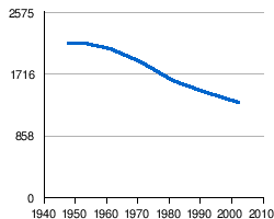
There are 1081 adult residents in the settlement of Lopatanj. The average age of the residents is 42.8 years (41.0 for men and 44.9 for women). The village has 385 households, the average number of residents per household is 3.45. The village is largely inhabited by Serbs (according to 2002 census),the last three censuses noticed a decline in the population.
- Changes in population during 20th Century

|
References
- Institut national d'études démographique (INED) Archived 2014-07-02 at the Wayback Machine
44°19′N 19°35′E / 44.317°N 19.583°E / 44.317; 19.583
This Serbia location article is a stub. You can help Misplaced Pages by expanding it. |