Village in West Bengal, India
| Loyada | |
|---|---|
| Village | |
  | |
| Coordinates: 22°26′51″N 87°37′47″E / 22.447611°N 87.629606°E / 22.447611; 87.629606 | |
| Country | |
| State | West Bengal |
| District | Paschim Medinipur |
| Population | |
| • Total | 1,520 |
| Languages* | |
| • Official | Bengali, Santali, English |
| Time zone | UTC+5:30 (IST) |
| PIN | 721136 |
| Telephone/STD code | 03222 |
| Lok Sabha constituency | Ghatal |
| Vidhan Sabha constituency | Debra |
| Website | paschimmedinipur |
Loyada (also spelled Lowada) is a village in the Debra CD block in the Kharagpur subdivision of the Paschim Medinipur district in the state of West Bengal, India.
Geography
5miles Kangsabati River SatyapurH
MadhyabarH
Railway SettlementCT
M: municipal city/ town, CT: census town, R: rural/ urban centre, H: historical/ religious centre, F: facilities
Owing to space constraints in the small map, the actual locations in a larger map may vary slightly
Location
Lowada is located at 22°26′51″N 87°37′47″E / 22.447611°N 87.629606°E / 22.447611; 87.629606.
Area overview
Kharagpur subdivision, shown partly in the map alongside, mostly has alluvial soils, except in two CD blocks in the west – Kharagpur I and Keshiary, which mostly have lateritic soils. Around 74% of the total cultivated area is cropped more than once. With a density of population of 787 per kmnearly half of the district's population resides in this subdivision. 14.33% of the population lives in urban areas and 86.67% lives in the rural areas.
Note: The map alongside presents some of the notable locations in the subdivision. All places marked in the map are linked in the larger full screen map.
Demographics
According to the 2011 Census of India, Loyada had a total population of 1,520, of which 780 (51%) were males and 740 (49%) were females. There were 211 persons in the age range of 0–6 years. The total number of literate persons in Loyada was 992 (75.78% of the population over 6 years).
.*For language details see Debra (community development block)#Language and religion
Education
Lowada High School is a Bengali-medium coeducational institution established in 1952. The school has facilities for teaching from class V to class XII. It has a library with 2,000 books, 10 computers and a playground.
Lowada Balika Vidyalaya is a Bengali-medium girls only institution established in 1971. The school has facilities for teaching from class V to class XII. It has a library with 534 books and 4 computers.
Culture
David J. McCutchion mentions:
- The Gopinath temple of the Mukherjee family as standard West Bengal type pancha-ratna, brick temple with terracotta, built in 1805
- The Sridhara temple of the Mukherjee family as a flat roofed or chandni type, with terracotta and stucco work
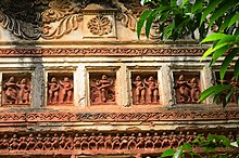
- The Radha-Govinda temple as a smooth rekha deul with a porch having low-founded pyramidal roof, built in 1860, having rich terracotta.
Laoada picture gallery
-
 Radhagobinda Jiu temple: Shikhar deul with porch in front
-
 Terracotta decoration in Radhagobindajiu temple
-
 Terracotta decoration in Radhagobindajiu temple
References
- "District Human Development Report Paschim Medinipur, 2011". page 27-28. Department of Planning and Statistics, Government of West Bengal. Retrieved 10 September 2020.
- "District Statistical Handbook Paschim Medinipur, 2013". Table 2.2, 2.4 (a). Department of Planning and Statistics. Retrieved 10 September 2020.
- "CD block Wise Primary Census Abstract Data(PCA)". West Bengal – District-wise CD blocks. Registrar General and Census, India. Retrieved 3 September 2020.
- "Lowada High School U Pry". Schools.org. Retrieved 4 September 2020.
- "Lowada Balika V. U. Pry". Schools.org. Retrieved 1 February 2020.
- McCutchion, David J., Late Mediaeval Temples of Bengal, first published 1972, reprinted 2017, page 46, 63, 72. The Asiatic Society, Kolkata, ISBN 978-93-81574-65-2
External links
| Temple towns in West Bengal | |
|---|---|
| Districts |
|
| Bankura |
|
| Birbhum |
|
| Cooch Behar |
|
| Darjeeling |
|
| Hooghly |
|
| Howrah | |
| Jalpaiguri | |
| Murshidabad |
|
| Nadia | |
| North 24 Parganas |
|
| Paschim Bardhaman |
|
| Paschim Medinipur |
|
| Purba Bardhaman | |
| Purba Medinipur |
|
| Purulia district |
|
| See also | |
