| Luhu | |
|---|---|
| Town | |
 | |
| Coordinates: 3°27′26″S 127°57′13″E / 3.45722°S 127.95361°E / -3.45722; 127.95361 | |
| Country | Indonesia |
| Province | Maluku |
| Regency | West Seram |
| Population | |
| • Total | 26,184 |
| Time zone | UTC+8 (WITA) |
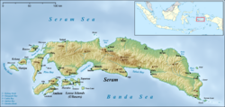
Luhu is a small town on the southwestern coast of the Indonesian island of Seram. It lies near the end of the Hoamoal Peninsula, between Kulur and Urieng on the tip. Luhu is noted for its Makassan traders, exporting cloves from the port. The clove industry took off in the first half of the 17th century, at the time when Luhu was a vassal of Tidore. The Dutch secured a military post at Luhu. The Luhu language is spoken in the vicinity.
References
- "Seram Island (map)". Indonesiatravelingguide.com. Retrieved 8 June 2015.
- Ellen, R. F. (January 2003). On the Edge of the Banda Zone: Past and Present in the Social Organization of a Moluccan Trading Network. University of Hawaii Press. p. 89. ISBN 978-0-8248-2676-5.
- Reuter, Thomas (1 January 2006). Sharing the Earth, Dividing the Land: Land and Territory in the Austronesian World. ANU E Press. p. 159. ISBN 978-1-920942-70-0.
- Widjojo, Muridan (10 December 2008). The Revolt of Prince Nuku: Cross-cultural Alliance-making in Maluku, c.1780-1810. BRILL. p. 157. ISBN 978-90-474-2533-5.
- Frawley, William J. (2003). International Encyclopedia of Linguistics. Oxford University Press. p. 298. ISBN 978-0-19-513977-8.
| Seram Island, Indonesia | |
|---|---|
| Settlements | |
| Geography | |
| Endemic fauna | |
| Native people and languages | |
This article about a location in Maluku Province is a stub. You can help Misplaced Pages by expanding it. |