Census-designated place & unincorporated community in Michigan, United States
| Lupton, Michigan | |
|---|---|
| Census-designated place (CDP) & unincorporated community | |
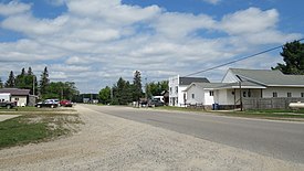
 Looking north along Main Street Looking north along Main Street | |
 Location within Ogemaw County Location within Ogemaw County | |
  | |
| Coordinates: 44°25′52″N 84°01′33″W / 44.43111°N 84.02583°W / 44.43111; -84.02583 | |
| Country | United States |
| State | Michigan |
| County | Ogemaw |
| Townships | Cumming and Rose |
| Settled | 1880 |
| Area | |
| • Total | 3.26 sq mi (8.45 km) |
| • Land | 3.23 sq mi (8.37 km) |
| • Water | 0.03 sq mi (0.08 km) |
| Elevation | 922 ft (281 m) |
| Population | |
| • Total | 318 |
| • Density | 98.39/sq mi (37.99/km) |
| Time zone | UTC-5 (Eastern (EST)) |
| • Summer (DST) | UTC-4 (EDT) |
| ZIP code(s) | 48635 |
| Area code | 989 |
| GNIS feature ID | 1620647 |
Lupton is an unincorporated community and census-designated place (CDP) in Ogemaw County in the U.S. state of Michigan. The population of the CDP was 318 at the 2020 census. Lupton is located mostly within Rose Township with a small portion extending south into Cumming Township.
History

Lupton was settled as early as 1880 by several Quaker families from Ohio, including that of Emmor Lupton. The community was first known as Lane Heights and given a post office under the name Lane on April 11, 1881. A depot on the Detroit, Bay City and Alpena Railroad was opened in January 1893. The post office was renamed Lupton in June 1893. The post office name changed to Lupton on June 8, 1893.
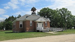
The Lupton Schoolhouse was constructed from 1903–1904 and served Lupton as the Rose Township District No. 5 School. The two-room schoolhouse remained in operation until 1963. The site was dedicated as a Michigan State Historic Site on April 20, 1995.
The community of Lupton was listed as a newly-organized census-designated place for the 2010 census, meaning it now has officially defined boundaries and population statistics for the first time.
The post office remained in operation until it was discontinued on November 5, 2011. Although the community contains no post office, the Lupton 48635 ZIP Code remains active is now served by the Rose City post office.
Geography
According to the U.S. Census Bureau, the community has an area of 3.26 square miles (8.44 km), of which 3.23 square miles (8.37 km) is land and 0.03 square miles (0.08 km) (0.92%) is water.
The Rifle River flows through Lupton, and the Rifle River State Recreation Area is just to the south and use the Lupton ZIP Code.
Climate
| Climate data for Lupton 1S, Michigan (1991–2020 normals, extremes 1951–present) | |||||||||||||
|---|---|---|---|---|---|---|---|---|---|---|---|---|---|
| Month | Jan | Feb | Mar | Apr | May | Jun | Jul | Aug | Sep | Oct | Nov | Dec | Year |
| Record high °F (°C) | 56 (13) |
61 (16) |
87 (31) |
89 (32) |
96 (36) |
105 (41) |
102 (39) |
102 (39) |
98 (37) |
89 (32) |
75 (24) |
66 (19) |
105 (41) |
| Mean daily maximum °F (°C) | 27.0 (−2.8) |
30.9 (−0.6) |
41.0 (5.0) |
54.4 (12.4) |
67.5 (19.7) |
76.9 (24.9) |
81.0 (27.2) |
79.1 (26.2) |
72.1 (22.3) |
57.7 (14.3) |
43.8 (6.6) |
32.5 (0.3) |
55.3 (12.9) |
| Daily mean °F (°C) | 18.5 (−7.5) |
19.9 (−6.7) |
29.1 (−1.6) |
41.7 (5.4) |
53.9 (12.2) |
63.2 (17.3) |
67.4 (19.7) |
65.7 (18.7) |
58.3 (14.6) |
46.3 (7.9) |
35.1 (1.7) |
25.1 (−3.8) |
43.7 (6.5) |
| Mean daily minimum °F (°C) | 10.0 (−12.2) |
8.9 (−12.8) |
17.2 (−8.2) |
29.0 (−1.7) |
40.2 (4.6) |
49.5 (9.7) |
53.8 (12.1) |
52.3 (11.3) |
44.6 (7.0) |
35.0 (1.7) |
26.4 (−3.1) |
17.7 (−7.9) |
32.1 (0.1) |
| Record low °F (°C) | −34 (−37) |
−41 (−41) |
−29 (−34) |
−4 (−20) |
17 (−8) |
25 (−4) |
30 (−1) |
26 (−3) |
20 (−7) |
11 (−12) |
−12 (−24) |
−25 (−32) |
−41 (−41) |
| Average precipitation inches (mm) | 1.83 (46) |
1.58 (40) |
1.94 (49) |
3.11 (79) |
3.49 (89) |
3.80 (97) |
3.52 (89) |
3.33 (85) |
2.90 (74) |
3.28 (83) |
2.49 (63) |
2.14 (54) |
33.41 (849) |
| Source: NOAA | |||||||||||||
Demographics
| Census | Pop. | Note | %± |
|---|---|---|---|
| 2020 | 318 | — | |
| U.S. Decennial Census | |||
References
- "2020 U.S. Gazetteer Files". United States Census Bureau. Retrieved May 21, 2022.
- "Lupton". Geographic Names Information System. United States Geological Survey, United States Department of the Interior.
- ^ "Michigan: 2010 Population and Housing Unit Counts 2010 Census of Population and Housing" (PDF). 2010 United States Census. United States Census Bureau. September 2012. pp. 37–38 Michigan. Retrieved August 17, 2021.
- Romig, Walter (1986) . Michigan Place Names. Detroit, Michigan: Wayne State University Press. ISBN 0-8143-1838-X.
- U.S. Geological Survey Geographic Names Information System: Lupton Post Office
- MichMarkers.com (2021). "Rose Township District No. 5 School: Registered Site L1933". Retrieved August 22, 2021.
- "Michigan: 2010 Population and Housing Unit Counts 2010 Census of Population and Housing" (PDF). 2010 United States Census. United States Census Bureau. September 2012. p. III-7. Retrieved August 8, 2016.
- United States Postal Service. "USPS - Look Up a ZIP Code". Retrieved May 13, 2018.
- "Postmaster Finder - Post Offices by ZIP Code". United States Postal Service. Retrieved May 13, 2018.
- "NOWData - NOAA Online Weather Data". National Oceanic and Atmospheric Administration. Retrieved April 2, 2024.
- "Summary of Monthly Normals 1991-2020". National Oceanic and Atmospheric Administration. Retrieved April 2, 2024.
- "Census of Population and Housing". Census.gov. Retrieved June 4, 2016.
| Municipalities and communities of Ogemaw County, Michigan, United States | ||
|---|---|---|
| County seat: West Branch | ||
| Cities |  | |
| Village | ||
| Civil townships | ||
| CDPs | ||
| Other communities | ||
| Footnotes | ‡This populated place also has portions in an adjacent county or counties | |
This Ogemaw County, Michigan location article is a stub. You can help Misplaced Pages by expanding it. |