 M621
M621 | ||||
|---|---|---|---|---|
| M621 highlighted in blue | ||||
| Route information | ||||
| Maintained by National Highways | ||||
| Length | 7.7 mi (12.4 km) | |||
| Existed | 1972–present | |||
| History | Constructed 1972–75 | |||
| Major junctions | ||||
| West end | Gildersome | |||
| Major intersections | M62 motorway M1 motorway | |||
| East end | Rothwell | |||
| Location | ||||
| Country | United Kingdom | |||
| Primary destinations | Leeds | |||
| Road network | ||||
| ||||
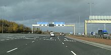
The M621 is a 7.7-mile-long (12 km) loop of motorway in West Yorkshire, England that takes traffic into central Leeds between the M1 and M62 motorways.
History
The first section of the M621 to open, known at the time as the 'South West Urban Motorway', extended from the M62 to junction 3 in central Leeds where it used to terminate at a roundabout which was also the terminus of the M1 motorway. This section opened in stages, first from the M62 to junction 1 in 1971 (this was originally numbered M65), and then next from junction 1 to junction 3 in 1973.
When the M1 was diverted away from Leeds when the 'M1 – A1 Lofthouse to Bramham' extension opened in 1999 adjustments were made to junction 3 and the Leeds section of the M1 was re-designated as M621, given junction 3 to junction 7).
Junctions
| County | Location | mi | km | Junction | Destinations | Notes |
|---|---|---|---|---|---|---|
| West Yorkshire | Morley | 0 | 0 | — | ||
| Leeds | 3.2 | 5.1 | 1 | |||
| 3.9 | 6.2 | 2 | ||||
| 4.3 | 7.0 | 2a | Eastbound entrance only | |||
| 4.8 | 7.8 | 3 | ||||
| 5.2 | 8.4 | 4 | ||||
| 5.6 | 9.0 | 5 | ||||
| 6.3 | 10.1 | 6 | Belle Isle | Eastbound exit and westbound entrance only | ||
| 6.9 | 11.1 | 7 | ||||
| 8.0 | 12.9 | — | Northbound entrance and southbound exit only | |||
| 1.000 mi = 1.609 km; 1.000 km = 0.621 mi | ||||||
- Coordinate list
- 53°44′49″N 1°38′44″W / 53.7470°N 1.6456°W / 53.7470; -1.6456 (M621, Start of motorway)
- 53°46′31″N 1°34′55″W / 53.7754°N 1.5820°W / 53.7754; -1.5820 (M621, Junction 1)
- 53°46′48″N 1°34′06″W / 53.7800°N 1.5684°W / 53.7800; -1.5684 (M621, Junction 2)
- 53°47′00″N 1°33′19″W / 53.7833°N 1.5553°W / 53.7833; -1.5553 (M621, Junction 2a)
- 53°47′05″N 1°32′49″W / 53.7846°N 1.5470°W / 53.7846; -1.5470 (M621, Junction 3)
- 53°46′51″N 1°32′21″W / 53.7808°N 1.5392°W / 53.7808; -1.5392 (M621, Junction 4)
- 53°46′29″N 1°32′24″W / 53.7747°N 1.5399°W / 53.7747; -1.5399 (M621, Junction 5)
- 53°46′14″N 1°32′01″W / 53.7705°N 1.5337°W / 53.7705; -1.5337 (M621, Junction 6)
- 53°46′03″N 1°30′53″W / 53.7675°N 1.5146°W / 53.7675; -1.5146 (M621, Junction 7)
- 53°45′07″N 1°30′59″W / 53.7520°N 1.5163°W / 53.7520; -1.5163 (M621, Start of motorway)
Gallery


References
- ^ "M621 motorway". roads.org.uk.
- "M1 – A1 Lofthouse to Bramham". Highways Agency. Archived from the original on 1 March 2012.
- "Leeds: Exit slip road at junction 2a on M621 closed permanently". BBC News. 20 June 2023.
External links
Map all coordinates using OpenStreetMapDownload coordinates as:
KML file (edit • help) Template:Attached KML/M621 motorwayKML is from Wikidata| Great Britain |  | |||||||||||||||||||
|---|---|---|---|---|---|---|---|---|---|---|---|---|---|---|---|---|---|---|---|---|
| Northern Ireland | ||||||||||||||||||||
| Former | ||||||||||||||||||||
| Unbuilt | ||||||||||||||||||||
| Junctions ( | ||||||||||||||||||||
| Bridges | ||||||||||||||||||||
| Related articles | ||||||||||||||||||||
| Strategic road network in England | |
|---|---|
| South West | |
| Area 3 (South) | |
| Area 4 (South East) | |
| Area 5 (DBFO) (M25 links) | |
| East | |
| Area 7 (East Midlands) | |
| Area 9 (West Midlands) | |
| North West | |
| Area 12 (Yorks/Lincs) | |
| Area 14 (North East) | |
| Other DBFO | |
| Toll roads | |
This England road or road transport-related article is a stub. You can help Misplaced Pages by expanding it. |