District of Uttar Pradesh in India
| Hathras district | |
|---|---|
| District of Uttar Pradesh | |
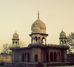
 Hathras Tample Hathras Tample | |
 Location of Hathras district in Uttar Pradesh Location of Hathras district in Uttar Pradesh | |
| Country | |
| State | Uttar Pradesh |
| Division | Aligarh |
| Headquarters | Hathras |
| Government | |
| • Lok Sabha constituencies | Hathras |
| Area | |
| • Total | 1,840 km (710 sq mi) |
| Population | |
| • Total | 1,564,708 |
| • Density | 850/km (2,200/sq mi) |
| Demographics | |
| • Literacy | 71.6% |
| • Sex ratio | 871 |
| Time zone | UTC+05:30 (IST) |
| Website | https://hathras.nic.in/ |
Hathras district (Hindi pronunciation: [ɦaːt̪ʰ.ɾəs]; previously called Mahamaya Nagar district) is a district of Uttar Pradesh state of India. The city of Hathras is the district headquarters. Hathras district is a part of Aligarh division. The district occupies an area of 1,840 square kilometres (710 sq mi) and has a population of 1,564,708 as of the 2011 census.
History
Hathras district was created on 3 May 1997 by incorporating parts of the Aligarh, Mathura, and Agra districts. It was originally named Mahamaya Nagar (named for Mayadevi, mother of the Buddha) and was renamed to Hathras district in 2012.
Divisions
The district comprises four tehsils: Hathras, Sadabad, Sikandra Rao, and Sasni, which are further divided into seven blocks: Sasni, Hathras, Mursan, Sadabad, Sahpau, Hasanpur Baru, Sikandra Rao, and Hasayan.
There are three Vidhan Sabha constituencies in this district: Hathras, Sadabad, and Sikandra Rao. All of these are part of Hathras Lok Sabha constituency.
Demographics
| Year | Pop. | ±% |
|---|---|---|
| 1901 | 446,863 | — |
| 1911 | 420,999 | −5.8% |
| 1921 | 386,670 | −8.2% |
| 1931 | 424,376 | +9.8% |
| 1941 | 500,838 | +18.0% |
| 1951 | 563,186 | +12.4% |
| 1961 | 645,924 | +14.7% |
| 1971 | 761,244 | +17.9% |
| 1981 | 919,454 | +20.8% |
| 1991 | 1,126,918 | +22.6% |
| 2001 | 1,336,031 | +18.6% |
| 2011 | 1,564,708 | +17.1% |
| Source: Census of India | ||
| Religions in Hathras district (2011) | ||||
|---|---|---|---|---|
| Religion | Percent | |||
| Hinduism | 89.30% | |||
| Islam | 10.19% | |||
| Other or not stated | 0.51% | |||
| Distribution of religions | ||||
According to the 2011 census, Hathras district has a population of 1,564,708, roughly equal to the nation of Gabon. This gives it a ranking of 319th in India (out of a total of 640). The district has an area of 1,840 square kilometres (710 sq mi) and a population density of 850 inhabitants per square kilometre (2,200/sq mi). Its population growth rate over the decade 2001–2011 was 17.12%. Hathras has a sex ratio of 871 females for every 1,000 males, and a literacy rate of 60.2%. 21.27% of the population lived in urban areas. Scheduled Castes made up 24.77% of the population.
Languages of Hathras district (2011)
Hindi (98.16%) Urdu (1.24%) Others (0.60%)At the time of the 2011 Census of India, 98.16% of the population in the district spoke Hindi and 1.24% Urdu as their first language. The local language is Braj.
Transport
Four railway stations serve Hathras: Hathras Junction railway station, Hathras Road railway station, Hathras City railway station, and Hathras Kila railway station.
Notable people
- Birendra Singh Rana (MLA)
- Kaka Hathrasi (Poet)
- Ramveer Upadhyay (MLA)
- Pradeep Kumar Singh (MLA)
See also
References
- ^ Sharat Pradhan (23 July 2012). "Akhilesh renames 8 major districts carved out by Mayawati - Rediff.com India News". rediff.com. Retrieved 10 February 2021.
when she carved out Mahamaya Nagar out of Ghaziabad district ... Akhilesh has now renamed the district as Hathras
- "Important Cabinet Decisions". Information and Public Relations Department. Archived from the original on 24 October 2014. Retrieved 17 January 2013.
- ^ "A-2: DECADAL VARIATION IN POPULATION SINCE 1901" (PDF). www.censusindia.gov.in. 30 May 2014. p. 5. Retrieved 19 October 2019.
- "Table C-01 Population by Religion: Uttar Pradesh". censusindia.gov.in. Registrar General and Census Commissioner of India. 2011.
- "District Census Handbook: Hathras" (PDF). censusindia.gov.in. Registrar General and Census Commissioner of India. 2011.
- US Directorate of Intelligence. "Country Comparison:Population". Archived from the original on 13 June 2007. Retrieved 1 October 2011.
Gabon 1,576,665
- ^ "A-1 Number Of Villages, Towns, Households, Population And Area" (XLS). www.censusindia.gov.in. 14 June 2018. Retrieved 19 October 2019.
- "Primary Census Abstract Data Tables (India & States/UTs - District Level)" (XLS). www.censusindia.gov.in. 2 February 2018. Retrieved 19 October 2019.
942,572 literate persons
- "(Text version of primary abstract data spreadsheet)". www.censusindia.gov.in. Retrieved 19 October 2019.
- ^ "Table C-16 Population by Mother Tongue: Uttar Pradesh". www.censusindia.gov.in. Registrar General and Census Commissioner of India.
| Places adjacent to Hathras district | ||||||||||||||||
|---|---|---|---|---|---|---|---|---|---|---|---|---|---|---|---|---|
| ||||||||||||||||