| This article possibly contains original research. Please improve it by verifying the claims made and adding inline citations. Statements consisting only of original research should be removed. (August 2017) (Learn how and when to remove this message) |
| Mangaldoi Mangaldai | |
|---|---|
| Town | |
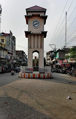
 View of Mangaldoi clock tower View of Mangaldoi clock tower | |
  | |
| Coordinates: 26°26′N 92°02′E / 26.43°N 92.03°E / 26.43; 92.03 | |
| Country | |
| State | Assam |
| District | Darrang |
| Administrative Division | North Assam Division |
| Sub-division | Mangaldai |
| Founded by | Government of Assam |
| Named for | Mangaldahi (Mongola Devi) |
| Government | |
| • Body | Mangaldoi Municipal Board |
| Area | |
| • Total | 10 km (4 sq mi) |
| Elevation | 34 m (112 ft) |
| Population | |
| • Total | 25,989 |
| • Density | 2,600/km (6,700/sq mi) |
| Demonym | Mangaldaian |
| Languages | |
| • Official | Assamese |
| Time zone | UTC+5:30 (IST) |
| PIN | 784125 |
| Vehicle registration | AS-13 |
| Sex ratio | 923:1000 ♂/♀ |
| Website | darrang |
Mangaldoi; also spelt Mangaldai, Assamese pronunciation: [mɔŋɔldoɪ], is a town in the state of Assam, India. It serves as the administrative headquarter of Darrang district.
Etymology
It's named after Mangaldahi, who was the daughter of the Raja of Darrang. She was married to the Susenghphaa (r.1603-1641), (also known as Pratap Singha), a ruler of the Ahom kingdom.
Geography
Mangaldoi is located at 26°26′N 92°02′E / 26.43°N 92.03°E / 26.43; 92.03. It has an average elevation of 34 m (112 ft).
Situated at the north bank of Brahmaputra river, the city is approximately 68 km from Guwahati and 94.1 km from Tezpur.
Governance
Mangaldoi is part of Mangaldoi (Lok Sabha constituency).
Basanta Das of Indian National Congress is the present MLA of Mangaldoi. Dilip Saikia of Bharatiya Janata Party is the present MP of Mangaldoi.
Demographics
As of 2011 India census, Mangaldoi had a population of 36,993 (including Gerimari). Males constituted 52% of the population and females 48%. Mangaldoi had an average literacy rate of 92.57%, higher than the national average of 74.04%: male literacy was 94.95%, and female literacy was 90.09%. In Mangaldoi, 11% of the population was below 6 years of age. The population is largely heterogeneous consisting Assamese, Bengali, Marwadi, Bihari, Punjabi communities. The town has a Hindu majority.
Language
Languages spoken in Mangaldoi (2011)
Assamese (81.42%)
Bengali (14.49%)
Hindi (2.36%)
others (1.73%)
Assamese is the most spoken language with 21,161 speakers, followed by Bengali at 3,767 and Hindi at 614.
Education
A major institution in Mangaldai is Assam Skill University (ASU), which is situated in Bidya Nagar. As the university continues to develop, its goal is to offer skill development programs in a range of fields, with an emphasis on boosting students' employability and promoting growth within the state. Besides government-run institutions, Mangaldai has also seen a rise in private educational establishments, which has significantly enhanced the area's educational infrastructure.
References
- Deka, Prodyut Kumar. Prophecy of Ambari. Educreation Publishing.
- Falling Rain Genomics, Inc - Mangaldoi
- "List of Parliamentary & Assembly Constituencies" (PDF). Assam. Election Commission of India. Archived from the original (PDF) on 4 May 2006. Retrieved 6 October 2008.
- "Census of India 2001: Data from the 2001 Census, including cities, villages and towns (Provisional)". Census Commission of India. Archived from the original on 16 June 2004. Retrieved 1 November 2008.