| This article needs additional citations for verification. Please help improve this article by adding citations to reliable sources. Unsourced material may be challenged and removed. Find sources: "Mariscal Luzuriaga province" – news · newspapers · books · scholar · JSTOR (February 2014) (Learn how and when to remove this message) |
| Mariscal Luzuriaga | |
|---|---|
| Province | |
 Looking west across a lake near Jarhuajara to the Cordillera Blanca Looking west across a lake near Jarhuajara to the Cordillera Blanca | |
 Flag Flag Coat of arms Coat of arms | |
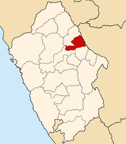
 Location of Mariscal Luzuriaga in the Ancash Region Location of Mariscal Luzuriaga in the Ancash Region | |
| Country | Peru |
| Region | Ancash |
| Capital | Piscobamba |
| Government | |
| • Mayor | Enrique Ponte Ayala |
| Area | |
| • Total | 731 km (282 sq mi) |
| Population | |
| • Total | 20,284 |
| • Density | 28/km (72/sq mi) |
Mariscal Luzuriaga (Spanish: mariscal, 'marshal') is one of 20 provinces of the Ancash Region in Peru. It was created by law 12541 on January 12, 1956, and named after the Peruvian marshal and Argentine general Toribio de Luzuriaga.
Since the Inca roads crossed its territory up to the Ecuador, where its capital Piscobamba is located now, there was a strategic tambo during the Inca's time. Pisqu Pampa means "bird plain" in Quechua. This place has a special attraction due to four mythical hills: Kampanayuq, Aswaq, Amañico and Wankash. Bloody battles were performed here by the armies of the Inca Tupac Yupanqui and the conchucos, piscopampas and huaras. See Garcilaso: "Comentarios reales" .
Geography
One of the highest peaks of the province is Tuqtupampa at approximately 5,240 m (17,190 ft). Other mountains are listed below:
- Allqu Maqasqa
- Anta Hirka
- Ch'aki Qucha
- Milla Hirka
- Muru Qucha
- Puka Hirka
- Pukarahu
- Uchu Hirka
- Ullukuyuq
- Uqsha Hirka
- Tawlli
- Usnu
- Wachaq Wari
- Yana Mach'ay
Political division
Mariscal Luzuriaga is divided into eight districts, which are:
Ethnic groups
The people in the province are mainly indigenous citizens of Quechua descent. Quechua is the language which the majority of the population (90.95%) learnt to speak in childhood, 8.51% of the residents started speaking using the Spanish language (2007 Peru Census).
50th Anniversary
In 2006, this province arrived at the 50th anniversary of its creation, by Law No. 12541, dated at January 12, 1956; president of Peru, general Manuel A. Odría. For those date edit, por celebrate the 50 years of provincial life, the book "Libro de Oro Luzuriaguino", with participation of a pool of authors.
See also
References
- Neyra Valverde: "Cómo resurge una Provincia Luzuriaguina" ISBN 978-612-00-1099-0 pg. 193
- Nonato Rufino Chuquimamani Valer, Carmen Gladis Alosilla Morales, Victoria Choque Valer: Qullaw Qichwapa Simi Qullqan. Lima, 2014 Archived 2014-11-29 at the Wayback Machine
- Neyra Valverde: "Provincia de Mariscal Luzuriaga. Capital Piscobamba.Distritos. Ediciones Iaccu", depósito legal BNP Nº2011-07837
- escale.minedu.gob.pe/ UGEL map province of Mariscal Luzuriaga (Ancash Region)
- inei.gob.pe Archived 2013-01-27 at the Wayback Machine INEI, Peru, Censos Nacionales 2007
- Neyra Valverde: "Provincia de Mariscal Luzuriaga " 2011, Depósito legal en BNP nº2011-07837
External links
| |
|---|---|
8°52′59″S 77°21′00″W / 8.88306°S 77.35000°W / -8.88306; -77.35000
This Ancash Region geography article is a stub. You can help Misplaced Pages by expanding it. |