United States historic place
| Marquette Street Archaeological District | |
| U.S. National Register of Historic Places | |
| U.S. Historic district | |
 Region of archaeological district Region of archaeological district | |
  | |
| Location | Near the St. Ignace Mission, St. Ignace, Michigan |
|---|---|
| Coordinates | 45°52′0″N 84°44′0″W / 45.86667°N 84.73333°W / 45.86667; -84.73333 |
| Area | 6 acres (2.4 ha) |
| NRHP reference No. | 82000541 |
| Added to NRHP | October 29, 1982 |
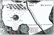
The Marquette Street Archaeological District is an archaeological site in St. Ignace, Michigan near the St. Ignace Mission. It covers 6 acres (2.4 ha) and includes one building, a village site, and a cemetery; archaeological designations are 20MK82 and 20MK99. It was listed on the National Register of Historic Places in 1982.
Early history

The Petun people originally lived east of Georgian Bay, but were driven by the Iroquois into what is now Wisconsin. In the 1660s, the Petun were again displaced by the Sioux, and settled in what is now St. Ignace around 1670. By this time, the reduction in numbers of Petun, due to disease and war, was so severe that some experts believe they were no longer culturally viable.
Père Jacques Marquette established his mission near the village a few years later. The village was home to 500-800 people. The Petun remained in this location until 1701, when Antoine de la Mothe Cadillac persuaded them to move south when he founded Detroit.
Excavations

The site of the Petun village in St. Ignace was excavated in the 1970s, and again in 1983-86, 1996–97, and 2001. Excavations have shown evidence of Petun longhouses and hearths, and acculturation from exposure to nearby European settlers. In particular, the Petun reused European glass and metal fragments to fashion weapons and ornaments, and incorporated elements of Christian worship into their own rituals. However, the Petun cultural identity remained despite their repeated displacement, reduction in numbers, and exposure to European culture and goods.
References
- ^ "National Register Information System". National Register of Historic Places. National Park Service. July 9, 2010.
- The NRIS gives the location of the Marquette Street Archaeological District as "Address Restricted"; however, multiple sources indicate the Petun village was near the St. Ignace Mission on the (three-block-long) Marquette Street. The geo-coordinates given are approximate.
- ^ Timothy Pauketat (2012), The Oxford Handbook of North American Archaeology Oxford Handbooks, Oxford University Press, pp. 424–425, ISBN 978-0195380118
- ^ Charles E. Orser (2002), Encyclopedia of Historical Archaeology, Psychology Press, pp. 373–364, ISBN 0415215447
- ^ Francis P. McManamon; Linda S. Cordell; Kent G. Lightfoot; George R. Milner (2009), Archaeology in America: Northeast and Southeast, ABC-CLIO, pp. 53–54, ISBN 978-0313331855
- "MICHIGAN - Dickinson County (NRIS database access)". NationalRegisterOfHistoricPlaces.com. Retrieved May 20, 2012.
Further reading
- Susan M Branstner, "Tionontate Huron Occupation at the Marquette Mission", Calumet Fleur-de-Lys: Archaeology of Indian and French Contact in the Mid-continent, Smithsonian Press: 177–201
| U.S. National Register of Historic Places | |
|---|---|
| Topics | |
| Lists by state |
|
| Lists by insular areas | |
| Lists by associated state | |
| Other areas | |
| Related | |
- Geography of Mackinac County, Michigan
- Archaeological sites in Michigan
- Archaeological sites on the National Register of Historic Places in Michigan
- Historic districts on the National Register of Historic Places in Michigan
- National Register of Historic Places in Mackinac County, Michigan
- Jacques Marquette