| Dajabón River Massacre River | |
|---|---|
 | |
 | |
| Location | |
| Countries | Dominican Republic and Haiti |
| Physical characteristics | |
| Mouth | Atlantic Ocean |
| • coordinates | 19°42′07″N 71°45′31″W / 19.70194°N 71.75861°W / 19.70194; -71.75861 |
| • elevation | Sea level |
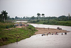
The Dajabón River (also called Massacre River) (French: Rivière du Massacre; Spanish: río Dajabón) is a river which forms the northernmost part of the international border between the Dominican Republic and Haiti.
Etymology
The river was named by the Arawak-speaking indigenous inhabitants of the island, the Taínos, as "Dahabōn", which derivates from dajaus, a freshwater fish that lives in the Caribbean region.
The French version of the river, "Rivière du Massacre" (River of Massacre), refers to a battle in 1728 where Spanish settlers killed thirty French buccaneers near the river. This name became popular after being the site of many killings during the Parsley Massacre—though the event was not, contrary to popular belief, the origin of its name.
Geography
It has its source in the Central Cordillera at Pico de Gallo mountain in the Dominican Republic. Further downstream through the Dominican province of Dajabón until it reaches the border between the Dominican Republic and Haiti, then it runs along the Haitian department of Northeast (left bank) and the Dominican provinces of Dajabón and Monte Cristi (right bank), then flows into Bay of Manzanillo and into the Atlantic Ocean west of the Dominican town of Pepillo Salcedo. It has a length of 55 kilometers of which a little more than 7KM are shared with Haiti. The Dominican town of Dajabón faces the Haitian town of Ouanaminthe.
In recent years it has lost its flow due to environmentally unsustainable practices, in particular the destruction of the forest due to massive felling without subsequent reforestation, and the practice of indiscriminately removing sand from the bed of the channel without any technical criteria.
History
In 2023, a dispute over water in the Dajabon River led the Dominican President Luis Abinader to close the border with Haiti. In 2024, disputes continue between the two countries over the use and management of the Masacre River's water resources. Issues such as border delimitation, river navigation and environmental preservation have exacerbated these tensions.
See also
References
- "Massacre River". National Geospatial Intelligence Agency, GeoNames server. Retrieved August 2, 2021.
- Jackson, Joe (8 December 2014). "Friendship bridge over Dajabon Massacre River". Al Jazeera.
- "The Origin of the Massacre Name for the Dajabon River". The Dominicans. 5 January 2019.
- Bishop, Marlon (7 October 2017). "80 Years On, Dominicans And Haitians Revisit Painful Memories Of Parsley Massacre". NPR.
- "Río Masacre nace en RD, tiene 55KM, comparte 7 con Haití y desemboca en Quisqueya" [The Massacre River originates in the DR, is 55 km long, shares 7 km with Haiti and flows into Quisqueya.]. n.com.do (in Spanish). 2023-09-12. Retrieved 2024-08-30.
- Kliment, Alex (17 September 2023). "Dispute over water rights threatens to close Haiti's border". GZERO. Retrieved 2023-09-17.
- Brand, Félix (March 28, 2024). "Border disputes over the Masacre River between Haiti and the Dominican Republic". www.infodiariord.com. Retrieved 2024-03-28.
- The Columbia Gazetteer of North America. 2000.
- CIA map
This article related to a river in the Dominican Republic is a stub. You can help Misplaced Pages by expanding it. |
This article related to a river in Haiti is a stub. You can help Misplaced Pages by expanding it. |