Town in Western Australia
| Meckering Western Australia | |
|---|---|
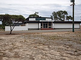
 Meckering Hall Meckering Hall | |
 | |
| Coordinates | 31°38′S 117°00′E / 31.633°S 117.000°E / -31.633; 117.000 |
| Population | 232 (SAL 2021) |
| Established | 1895 |
| Postcode(s) | 6405 |
| Elevation | 203 m (666 ft) |
| Area | 216 km (83 sq mi) |
| Location | |
| LGA(s) | Shire of Cunderdin |
| State electorate(s) | Central Wheatbelt |
| Federal division(s) | Durack |
Meckering is a town 130 kilometres (80.8 mi) east of Perth, Western Australia along the Great Eastern Highway. Meckering is located within the Shire of Cunderdin.
A railway line was completed in the area in 1895 and Meckering was selected as a station site. The first name chosen for the townsite was Beebering, the Aboriginal name for the hills just north of the town.
The townsite of Beebering was gazetted in 1895. The name of the town was changed to Meckering in 1897 to agree with the station name and the name for the town that was used locally. Meckering is an Aboriginal word thought to mean "moon on the water" or "good hunting".
In early 1898 the population of the town was 225, 150 males and 75 females.
In 1932 the Wheat Pool of Western Australia announced that the town would have two grain elevators, each fitted with an engine, installed at the railway siding.
The surrounding areas produce wheat and other cereal crops. The town is a receival site for Cooperative Bulk Handling.
Earthquake
Main article: 1968 Meckering earthquakeThe town was struck by an earthquake on Monday 14 October 1968.
The earthquake occurred at 10:58:52 local time, with a moment magnitude of 6.5 and a maximum Mercalli intensity of IX (Violent). Total damage amounted to $2.2 million with 20–28 injured.
Transport
Road freight
Meckering is a main stopping point for freight trucks on the way to the eastern states.
Passenger rail service
The MerredinLink service runs between East Perth and Merredin thrice weekly, terminating at Meckering. The Prospector service between East Perth and Kalgoorlie stops at Meckering most days.
Photography museum
Meckering is home to "The Big Camera" – so named because the building resembles a camera – a museum of photography with a collection of over 4000 cameras. The collection includes items from the late 1800s up to modern cameras, as well as related items such as projectors and light meters.
See also
References
- Australian Bureau of Statistics (28 June 2022). "Meckering (suburb and locality)". Australian Census 2021 QuickStats. Retrieved 28 June 2022.

- "History of country town names – M". Western Australian Land Information Authority. Archived from the original on 14 March 2022. Retrieved 16 September 2008.
- "Population of Western Australia". Western Mail. Perth: National Library of Australia. 22 April 1898. p. 23. Retrieved 6 April 2013.
- "Country elevators". The West Australian. Perth: National Library of Australia. 6 July 1932. p. 10. Retrieved 6 April 2013.
- "CBH receival sites" (PDF). 2011. Archived from the original (PDF) on 18 March 2012. Retrieved 1 April 2013.
- Bunbury, Bill, 1940-; ABC Radio (Australia). Social History Unit (1986), The Story of the Meckering earthquake, ABC Radio Tapes, retrieved 13 March 2019
{{citation}}: CS1 maint: multiple names: authors list (link) CS1 maint: numeric names: authors list (link) - "AvonLink and MerredinLink Timetable" (PDF). Transwa. Public Transport Authority. Archived (PDF) from the original on 13 March 2020. Retrieved 28 June 2020.
- "Prospector Timetable" (PDF). Transwa. Public Transport Authority. Archived (PDF) from the original on 18 June 2020. Retrieved 28 June 2020.
- "Wheatbelt town of Meckering has more cameras than people thanks to one man's passion". Australian Broadcasting Corporation. 29 December 2024. Retrieved 29 December 2024.
- "The Big Camera". Shire of Cunderdin. Retrieved 29 December 2024.
- "The Big Camera". Retrieved 29 December 2024.
Further reading
- Gordon, F.R and J.D. Lewis (1980) The Meckering and Calingiri earthquakes October 1968 and March 1970 Geological Survey of Western Australia Bulletin 126 ISBN 0-7244-8082-X
External links
- History of earthquakes in Western Australia
- Shire of Cunderdin – History of Meckering
- Meckering earthquake