| Mena River | |
|---|---|
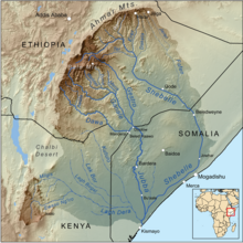
 The Mena River shown as a tributary of the Ganale River in Bale Zone, eastern Ethiopia The Mena River shown as a tributary of the Ganale River in Bale Zone, eastern Ethiopia | |
| Location | |
| Country | Ethiopia |
| Regions | Oromia, Somali |
| Physical characteristics | |
| Source | |
| • location | Bale Mountains |
| • coordinates | 6°55′52″N 40°11′27″E / 6.931156°N 40.190713°E / 6.931156; 40.190713 |
| • elevation | 3,101 m (10,174 ft) |
| Mouth | Ganale Dorya River |
| • coordinates | 5°32′30″N 41°10′59″E / 5.541645°N 41.183107°E / 5.541645; 41.183107 |
| • elevation | 280 m (920 ft) |
| Length | 298 km (185 mi) |
| Basin size | 9,081 km (3,506 sq mi) |
| Discharge | |
| • location | Mouth |
| • average | 35.1 m/s (1,240 cu ft/s) |
| • minimum | 6.96 m/s (246 cu ft/s) |
| • maximum | 109.2 m/s (3,860 cu ft/s) |
| Basin features | |
| Progression | Ganale Dorya → Jubba → Somali Sea |
| River system | Jubba Basin |
| Population | 206,000 |
The Mena is a river of eastern Ethiopia. It is located in the Delo Menna woreda in Bale Zone, Oromia Region. Its source lies in the Bale Mountains. It is a tributary of the Ganale Dorya.
This article related to a river in Ethiopia is a stub. You can help Misplaced Pages by expanding it. |
References
- ^ Lehner, Bernhard; Verdin, Kristine; Jarvis, Andy (2008-03-04). "New Global Hydrography Derived From Spaceborne Elevation Data". Eos, Transactions American Geophysical Union. 89 (10): 93–94. doi:10.1029/2008eo100001. ISSN 0096-3941.
- Liu, L., Cao, X., Li, S., & Jie, N. (2023). GlobPOP: A 31-year (1990-2020) global gridded population dataset generated by cluster analysis and statistical learning (1.0) . Zenodo. https://doi.org/10.5281/zenodo.10088105
- ^ Hazel, Robert (2020-05-07). Snakes, People, and Spirits, Volume Two: Traditional Eastern Africa in its Broader Context. Cambridge Scholars Publishing. ISBN 978-1-5275-5045-2.