Suburb of Gold Coast, Queensland, Australia
| Mermaid Beach Gold Coast, Queensland | |||||||||||||||
|---|---|---|---|---|---|---|---|---|---|---|---|---|---|---|---|
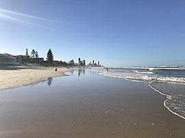
 Mermaid Beach, looking North Mermaid Beach, looking North | |||||||||||||||
 | |||||||||||||||
| Coordinates | 28°02′54″S 153°26′13″E / 28.0483°S 153.4369°E / -28.0483; 153.4369 | ||||||||||||||
| Population | 7,329 (2021 census) | ||||||||||||||
| • Density | 4,890/km (12,700/sq mi) | ||||||||||||||
| Postcode(s) | 4218 | ||||||||||||||
| Elevation | 7 m (23 ft) | ||||||||||||||
| Area | 1.5 km (0.6 sq mi) | ||||||||||||||
| Time zone | AEST (UTC+10:00) | ||||||||||||||
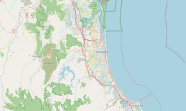
| Location |
| ||||||||||||||
| LGA(s) | City of Gold Coast | ||||||||||||||
| State electorate(s) | Mermaid Beach | ||||||||||||||
| Federal division(s) | Moncrieff | ||||||||||||||
| |||||||||||||||
Mermaid Beach is a coastal suburb of the City of Gold Coast in Queensland, Australia. In the 2021 census, Mermaid Beach had a population of 7,329 people.
Nobby Beach is a neighbourhood in the south of the suburb (28°03′32″S 153°26′29″E / 28.0589°S 153.4414°E / -28.0589; 153.4414 (Nobby Beach)).
Geography

The suburb is bounded to the west by the artificial canals of adjacent Mermaid Waters and to the east by the Pacific Ocean. To the north is the suburb of Broadbeach, to the south Miami. The Gold Coast Highway passes through Mermaid Beach.
The Gold Coast Oceanway (a pedestrian path) travels along Hedges Avenue.
History

Mermaid Beach receives its name from the cutter HMS Mermaid. Explorer John Oxley sailed aboard the Mermaid in 1823 when he discovered the nearby Tweed and Brisbane rivers.
Mermaid Beach was used during World War II by US servicemen and was named Los Angeles Beach as well as Miami Beach to the south.
Circa 1924, 70 allotments were advertised as "Mermaid Beach Estate" located at Mermaid Beach and Broadbeach to be auctioned by R. G. Oates Estates. The estate map has 3 estates for sale at Mermaid Beach and Broadbeach. The estates were divided in two by the "New Coastal Road" running through the Gold Coast.
Magic Mountain, Nobby Beach opened up in 1962
On 24 August 1975, the first McDonald's restaurant in Queensland opened in Mermaid Beach.
St James' Anglican Church was dedicated on 11 November 1977 by Assistant Bishop Ralph Wicks. Its closure on 15 August 1993 was approved by Assistant Bishop Ron Williams.
Demographics
In the 2011 census, Mermaid Beach had a population of 5,722 people.
In the 2016 census, Mermaid Beach had a population of 6,533 people.
In the 2021 census, Mermaid Beach had a population of 7,329 people.
Education
There are no schools in Mermaid Beach but there are primary schools in neighbouring Broadbeach and Mermaid Waters and a secondary school in Mermaid Waters.
Amenities
The Mermaid Beach branch of the Queensland Country Women's Association meets at QCWA Hall at 43 Ventura Road (28°02′27″S 153°26′05″E / 28.0407°S 153.4346°E / -28.0407; 153.4346 (Mermaid Beach CWA Hall)).
Other community groups include:
- Mermaid Beach Surf Life Saving Club
- Nobby Beach Surf Life Saving Club
References
- ^ Australian Bureau of Statistics (28 June 2022). "Mermaid Beach (SAL)". 2021 Census QuickStats. Retrieved 4 March 2023.

- ^ "Mermaid Beach (suburb) (entry 46061)". Queensland Place Names. Queensland Government. Retrieved 13 September 2015.
- "Nobby Beach – neighbourhood in the City of Gold Coast (entry 39209)". Queensland Place Names. Queensland Government. Retrieved 27 May 2021.
- ^ "Queensland Globe". State of Queensland. Retrieved 24 January 2024.
- Millionaires Mile Archived 2006-08-21 at the Wayback Machine
- "Mermaid Beach Estate main Southport surfing centre" (n.d.) . Collections. State Library of Queensland.
- "MARKET QUIET". Daily Mail. No. 6827. Queensland, Australia. 15 January 1924. p. 12. Archived from the original on 31 May 2022. Retrieved 26 February 2019 – via National Library of Australia.
- Potts, Andrew (13 April 2020). "Gold Coast development: Then and now - famous Gold Coast buildings revealed". Gold Coast Bulletin. Archived from the original on 24 January 2024. Retrieved 24 January 2024.
- "Closed Anglican Churches". Anglican Church South Queensland. Archived from the original on 3 April 2019. Retrieved 29 June 2020.
- Australian Bureau of Statistics (31 October 2012). "Mermaid Beach (SSC)". 2011 Census QuickStats. Retrieved 7 March 2023.

- Australian Bureau of Statistics (27 June 2017). "Mermaid Beach (SSC)". 2016 Census QuickStats. Retrieved 20 October 2018.

- "Branch Locations". Queensland Country Women's Association. Archived from the original on 26 December 2018. Retrieved 26 December 2018.
- "Mermaid Beach Surf Club". Archived from the original on 25 October 2022. Retrieved 27 May 2021.
- "Nobbys Beach Surf Club". Nobbys Beach Surf Club. Archived from the original on 28 October 2023. Retrieved 27 May 2021.
External links
- "Mermaid Beach". Queensland Places. Centre for the Government of Queensland, University of Queensland.