| Mitata Μητάτα | |
|---|---|
| Community | |
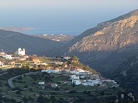
 Mitata with Palaiopoli in the background Mitata with Palaiopoli in the background | |
 | |
| Coordinates: 36°14′49″N 22°59′39″E / 36.24694°N 22.99417°E / 36.24694; 22.99417 | |
| Country | Greece |
| Administrative region | Attica |
| Regional unit | Islands |
| Municipality | Kythira |
| Municipal unit | Kythira |
| Elevation | 185 m (607 ft) |
| Population | |
| • Community | 217 |
| Time zone | UTC+2 (EET) |
| • Summer (DST) | UTC+3 (EEST) |
| Postal code | 80100 |
| Area code(s) | +30 27360 |
Mitata is a small village and community in the middle of the island of Kythira, Greece. Its average elevation is 185 m. Population 217 (2021).
History
In 2006, an earthquake shattered Ayia Triadon making it no longer able to host church services. Mitata is on a cliff side looking over the neighbouring village of Viaradika. There is a cave underneath the Windmill resort called the "Mavri Spilaia" or "Black Cave".
Notable people
References
- ^ "Αποτελέσματα Απογραφής Πληθυσμού - Κατοικιών 2021, Μόνιμος Πληθυσμός κατά οικισμό" [Results of the 2021 Population - Housing Census, Permanent population by settlement] (in Greek). Hellenic Statistical Authority. 29 March 2024.
- "Population & housing census 2001 (incl. area and average elevation)" (PDF) (in Greek). National Statistical Service of Greece. Archived (PDF) from the original on 2015-09-21.
- "Notable Kytherians - George Miller". www.kythera-family.net. Retrieved 2017-07-20.
| Subdivisions of the municipality of Kythira | |
|---|---|
| Municipal unit of Antikythera | |
| Municipal unit of Kythira |
|