| Mitterlabill | |
|---|---|
| Former municipality | |
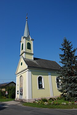
 Chapel in Mitterlabill Chapel in Mitterlabill | |
 | |
| Coordinates: 46°53′00″N 15°38′00″E / 46.88333°N 15.63333°E / 46.88333; 15.63333 | |
| Country | Austria |
| State | Styria |
| District | Leibnitz |
| Area | |
| • Total | 7.88 km (3.04 sq mi) |
| Elevation | 309 m (1,014 ft) |
| Population | |
| • Total | 414 |
| • Density | 53/km (140/sq mi) |
| Time zone | UTC+1 (CET) |
| • Summer (DST) | UTC+2 (CEST) |
| Postal code | 8413 |
| Area code | +43 3184 |
| Vehicle registration | FB |
| Website | www.mitterlabill. steiermark.at |
Mitterlabill is a former municipality in the district of Südoststeiermark in the Austrian state of Styria. Since the 2015 Styria municipal structural reform, it is part of the municipality Schwarzautal, in the Leibnitz District.
Population
| Year | Pop. | ±% |
|---|---|---|
| 1869 | 514 | — |
| 1880 | 534 | +3.9% |
| 1890 | 511 | −4.3% |
| 1900 | 531 | +3.9% |
| 1910 | 489 | −7.9% |
| 1923 | 516 | +5.5% |
| 1934 | 474 | −8.1% |
| 1939 | 461 | −2.7% |
| 1951 | 449 | −2.6% |
| 1961 | 443 | −1.3% |
| 1971 | 443 | +0.0% |
| 1981 | 464 | +4.7% |
| 1991 | 456 | −1.7% |
| 2001 | 447 | −2.0% |
| 2013 | 399 | −10.7% |
References
- Statistik Austria - Bevölkerung zu Jahresbeginn 2002-2016 nach Gemeinden (Gebietsstand 1.1.2016) for Mitterlabill.
- Die neue Gemeindestruktur der Steiermark
This Styria location article is a stub. You can help Misplaced Pages by expanding it. |