| Mochudi | |
|---|---|
| Village | |
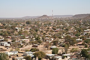
 View of Mochudi from a church bell tower View of Mochudi from a church bell tower | |
 | |
 | |
| Coordinates: 24°25′S 26°09′E / 24.417°S 26.150°E / -24.417; 26.150 | |
| Country | Botswana |
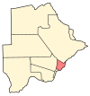
| District | Kgatleng District |
| Settled | 1871 |
| Elevation | 938 m (3,077 ft) |
| Population | |
| • Total | 50,321 |
| Time zone | GMT +2 |
| Climate | BSh |
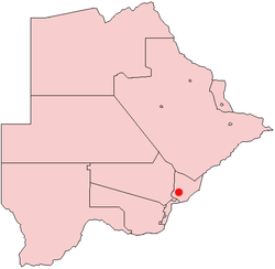
Mochudi is one of the larger villages in Botswana with a population of 50,321 people in 2022. It is situated in the Bakgatla tribal region, in Kgatleng District, about 37 km (23 mi) northeast of Gaborone. The village lies several kilometres from the main Gaborone–Francistown road, and can be accessed through a short turn at Pilane. Mochudi was settled by the Tswana people in 1871. The main attraction in Mochudi is the Phuthadikobo Museum which is perched at the top of a hill and holds a rich history of Bakgatla tribe and Batswana in general.
History
Mochudi was established as a result of people movements. Under pressure from Boer encroachment on their historic lands, the Bakgatla tribe migrated from what is now South Africa, settling in 1871 at the foot of Phuthadikobo Hill and beside the Notwane River. At this time, the Rev Pieter Brink of the Dutch Reformed Church founded a mission station at Mochudi.
Tourism
The tourist destinations of note inside Mochudi are the Phuthadikobo Museum at the top of the hill, which contains old photographs and historical texts relating to Mochudi and the history of the Bakgatla people. It is housed in a building that was originally the first school of Mochudi. Nearby is the hulk of the first tractor owned by a Motswana and huge footprints that legend says belongs to "Matsieng", a giant and ancestor of the Tswana, who led his people and the animals from the centre of the earth to inhabit the world.
Mochudi is known for its traditional painted houses and still has a traditional kgotla (tribal meeting place).
Mochudi was the birthplace of Mma Ramotswe, the heroine of the No. 1 Ladies' Detective Agency series of books. Michelle Obama visited the village during U.S. President Obama's African tour in 2011.
Education
Mochudi has several public Junior Secondary Schools and one public high school, Molefi Senior Secondary School. Several junior schools are Linchwe II JSS, Kgamanyane JSS, Radikolo JSS, Bakgatle JSS, Sedibelo JSS, and Ithuteng JSS. There is also Podulogong Rehabilitation Centre that offers hands on training courses to blind or vision impaired individuals.
Sports
Mochudi is home to Botswana Premier League soccer club Mochudi Centre Chiefs. Mochudi Rugby Club is a local rugby team based in the village.
Twin city
References
- "2011 census". Archived from the original on January 11, 2013.
- "Botswana: Districts, Cities, Towns, Urban Villages & Agglomerations - Population Statistics, Maps, Charts, Weather and Web Information". www.citypopulation.de. Retrieved 2024-10-04.
- Latitude.to. "GPS coordinates of Mochudi, Botswana. Latitude: -24.4167 Longitude: 26.1500". Latitude.to, maps, geolocated articles, latitude longitude coordinate conversion. Retrieved 2020-05-29.
- Botswana Tourism Organisation
- Matisieng Footprints - Attractions - Tourism of Botswana
- Gaotlhobogwe, M. Michelle Obama shows Botho with magwinya and chips. Mmegi Online, Retrieved March 3, 2013.
External links
- Botswana Tourism homepage The Government of Botswana - Home
- https://www.britannica.com/place/Mochudi
| Urban villages |  | |
|---|---|---|
| Rural villages | ||
| Capitals of Districts of Botswana | ||||||
|---|---|---|---|---|---|---|
| Capital, District | ||||||
 | ||||||
| Italics indicates national capital. | ||||||
| 50 largest cities of Botswana by population | |||||||
|---|---|---|---|---|---|---|---|
| Italics indicate capitals of districts | |||||||
| Retrieved from 2011 Census | |||||||
24°25′S 26°09′E / 24.417°S 26.150°E / -24.417; 26.150
Categories: