| Montes Taurus | |
|---|---|
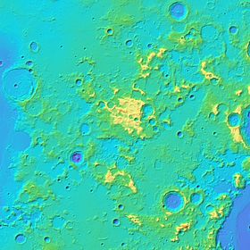
 Montes Taurus. Edge of Mare Serenitatis is seen in the left and edge of Mare Crisium in the lower right. Image width is 700 km. Montes Taurus. Edge of Mare Serenitatis is seen in the left and edge of Mare Crisium in the lower right. Image width is 700 km. | |
| Highest point | |
| Elevation | 2.1 km above mean level of lunar surface |
| Listing | Lunar mountains |
| Coordinates | 27°19′N 40°20′E / 27.32°N 40.34°E / 27.32; 40.34 |
| Naming | |
| English translation | Taurus Mountains |
| Language of name | Latin |
| Geography | |
| Location | the Moon |

Montes Taurus is a rugged, jumbled mountainous region on the Moon. It is located to the east of the Mare Serenitatis, in the northeastern quadrant of the Moon's near side. Coordinates of their center are 27°19′N 40°20′E / 27.32°N 40.34°E / 27.32; 40.34 (Montes Taurus), and their extent is about 170 km.
Montes Taurus are rather unimpressive and indistinct compared to other named lunar mountain systems. It is a broad hilly region without sharp borders. These mountains reach maximal height between craters Kirchhoff and Newcomb (4.9 km above Mare Serenitatis and 2.1 km above mean level of lunar surface).
A number of craters lie embedded within this range. At the southwestern edge of the region is the crater Römer, and Newcomb is located in the northeastern section. Several satellite craters also lie throughout the Montes Taurus. The southwestern edge of this region hosts Taurus–Littrow valley, the landing site of the crewed Apollo 17 mission.
Name
The Montes Taurus are named after the Taurus Mountains in southern Turkey. This name appeared on the lunar map due to Johannes Hevelius, who used to name lunar features after terrestrial ones. But he assigned this name (in the form Mons Taurus) to a completely different feature — one of bright rays of crater Tycho. The item of this article was designated as Taurica Chersonnesus, because Hevelius tried to establish a correspondence between lunar regions and regions of vicinity of Mediterranean sea, and on his map this lunar region corresponded to Crimea (historically known as Tauris or Tauric Chersonese). Later lunar cartographers began to call it Montes Taurus, and in 1935 this name was adopted by International Astronomical Union.
References
- ^ Altimetric data by Lunar Reconnaissance Orbiter, obtained via JMARS
- ^ "Montes Taurus". Gazetteer of Planetary Nomenclature. International Astronomical Union (IAU) Working Group for Planetary System Nomenclature (WGPSN). 2010-10-18. Retrieved 2014-11-27.
- Chuck Wood (2006-10-30). "Hardly Mountains". Lunar picture of the day. Archived from the original on 2014-10-09. Retrieved 2015-02-15.
- Hevelius J. (1647). Selenographia sive Lunae descriptio. Gedani: Hünefeld. pp. 226–227, 235. doi:10.3931/e-rara-238. (Mons Taurus and Taurica Chersonnesus are mentioned in a name list on p. 235)
- Whitaker E. A. (2003). Mapping and Naming the Moon: A History of Lunar Cartography and Nomenclature. Cambridge University Press. pp. 208, 209. ISBN 9780521544146.
This article related to the Moon is a stub. You can help Misplaced Pages by expanding it. |