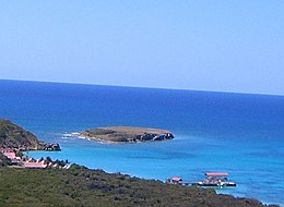
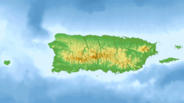
 Isla Morrillito, looking south from the Caja de Muertos Light Isla Morrillito, looking south from the Caja de Muertos Light | |
   | |
| Geography | |
|---|---|
| Location | Ponce, Puerto Rico |
| Coordinates | 17°52′56″N 66°31′59″W / 17.88222°N 66.53306°W / 17.88222; -66.53306 |
| Area | 0.04 km (0.015 sq mi) |
| Administration | |
| Commonwealth | Puerto Rico |
| Municipality | Ponce |
| Barrio | Playa |
| Demographics | |
| Population | 0 |
| Pop. density | 0/km (0/sq mi) |
Morrillito is a small uninhabited island off the southern coast of Puerto Rico. The island is protected by the Reserva Natural Caja de Muertos natural reserve because of its native turtle traffic. Together with Caja de Muertos, Gatas, Ratones, Cardona, Isla del Frio, and Isla de Jueyes, Morrillito is one of seven islands ascribed to the municipality of Ponce.
Location
The island, sometimes erroneously termed a key (or, cay), is located 5.2 mi (8.4 km) south of the Puerto Rican mainland and is part of Barrio Playa ward of the Ponce, Puerto Rico, municipality. It is located 590 feet (180 meters) off the southwest point of Caja de Muertos island and has an area of just 0.015 square miles (0.039 km). The island is connected to Caja de Muertos by a bank of shallow waters about 18.0 feet (5.5 meters) deep. It is located at latitude 17.88417 and longitude -66.53361. Its length is 0.31 miles (0.50 kilometers) northeast and southwest.
Geography and climate
The island is a small 31-foot flat-topped island located 200 yards off the southwestern tip of Caja de Muertos and, when viewed from a distance, Morrillito can easily be mistaken for the 170-ft steep hill (called Cerro Morrillo, Morrillo Hill) at the extreme southwestern portion of Caja de Muertos proper. The climate is dry and the island supports a dry forest.
Natural reserve
Together with Caja de Muertos (0.59 square miles (1.5 km) and Berberia Key (0.12 square miles (0.31 km), Morrillito makes up the Caja de Muertos Natural Reserve. The island was designated as a nature reserve in 1980 after a meeting was held in Puerto Rico by the Puerto Rico Planning Board wherein they considered the recommendation set forth by the Coastal Management Zone Program to turn the island into a protected wilderness area. The island has remained a protected area ever since. The protection is mainly due to its heavy Hawksbill sea turtle traffic which is an endangered species.
See also
References
- La Reserva Natural Isla Caja de Muertos. Hojas de Nuestro Ambiente. Archived 2011-06-04 at the Wayback Machine Estado Libre Asociado de Puerto Rico. Departamento de Recursos Naturales y Ambientales. Octubre 2006 - Rev. Julio 2009. P-009. Retrieved 24 May 2011.
- Neysa Rodriguez Deynes. Brevario Sobre la Historia de Ponce. Second Edition. Government of the Autonomous Municipality of Ponce. 2002. Page 9. Printed by Impress Quality Printing, Bayamon, Puerto Rico.
- CityMelt. Retrieved 17 May 2011.
- General Purpose Population Data, Census 2000. Unidad de Sistemas de Información Geográfica, Área de Tecnología de Información Gubernamental, Oficina de Gerencia y Presupuesto. Gobierno de Puerto Rico. Archived 2010-08-12 at the Wayback Machine Retrieved February 16, 2010.
- US Census. 1930 Federal Census Team Transcription. Retrieved February 22, 2010.
- Isla Caja de Muerto Natural Reserve . Encyclopedia Puerto Rico. Retrieved 26 April 2011.
- Isla Morrillito. Get-a-Map.net. Retrieved 26 April 2011.
- West Indies Pilot, Volume 1. United States Hydrographic Office. Page 592. Fourth Edition: 1922.
- Booklet Chart: Isla Petrona to Isla Caja de Muertos. Archived 28 April 2011 at the Wayback Machine 25685 - NOAA - National Oceanic and Atmospheric Administration. Retrieved 26 April 2011.
- Isla del Frio. Mapquest. Retrieved 26 April 2011.
- Puerto Rico.com: The Puerto Rico Channel. Visiting Caja de Muertos Island Nature Reserve.
- Isla Caja de Muerto Natural Reserve . Encyclopedia Puerto Rico. Retrieved 26 April 2011.
External links
- See an aerial photo of flat-surfaced Morrillito (taken looking north) HERE. Source: "¡Una obra magistral Puerto Rico 365!" La Perla del Sur. Ponce, Puerto Rico. (Title in printed edition: "Plasma en Puerto Rico 365° las joyas del archipiélago: la publicación ofrece 224 páginas de expectaculares fotografías." Year 32. Number 1518. Page 20.) Both versions published 2 January 2013. Retrieved 3 January 2013.
- Natural Reserve, official page
- Morrillito at Panoramio
- Heatwole, Harold; Levins, Richard; Byer, Michael D. (July 1981). "Biogeography of the Puerto Rican bank". Atoll Research Bulletin. 251: 1–55. OCLC 45726059. Retrieved 5 February 2020.
