| Mount Barnard | |
|---|---|
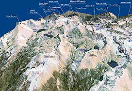
 A 3D image of Mount Whitney based on topographic data from NASA and World Imagery. Mount Barnard mount appears in the upper left. A 3D image of Mount Whitney based on topographic data from NASA and World Imagery. Mount Barnard mount appears in the upper left. | |
| Highest point | |
| Elevation | 13,996 ft (4,266 m) NAVD 88 |
| Prominence | 932 ft (284 m) |
| Parent peak | Mount Tyndall |
| Listing |
|
| Coordinates | 36°37′42″N 118°19′18″W / 36.6284032°N 118.3215994°W / 36.6284032; -118.3215994 |
| Geography | |
  | |
| Location | Inyo / Tulare counties, California, U.S. |
| Parent range | Sierra Nevada |
| Topo map | USGS Mount Williamson |
| Climbing | |
| First ascent | 1892 by W. L. Hunter, John Hunter, William Hunter and C. Mulholland. |
| Easiest route | Simple scramble, class 2 |
Mount Barnard is a mountain in the U.S. state of California, and has the dubious distinction of being the highest thirteener, a peak between 13,000 and 13,999 feet (3,962 and 4,267 m) in elevation, in the United States. It is located on the Sierra Crest and straddles the boundary between Tulare and Inyo counties about 2 miles (3 km) southwest of Mount Williamson, the second-highest peak in the state; Mount Barnard is the twelfth-highest.
The first ascent was by W. L. Hunter, John Hunter, William Hunter and C. Mulholland on September 25, 1892. They named the peak in honor of E. E. Barnard, a noted astronomer.
References
- ^ "Mount Barnard, California". Peakbagger.com. Retrieved 2012-07-30.
- "Key Col for Mount Barnard". Peakbagger.com. Retrieved 2016-03-26.
- "Sierra Peaks Section List" (PDF). Angeles Chapter, Sierra Club. Retrieved 2016-03-26.
- "Vagmarken Sierra Crest List". Angeles Chapter, Sierra Club. Retrieved 2021-11-23.
- "Western States Climbers Qualifying Peak List". Climber.org. Retrieved 2016-03-26.
- "Mount Barnard". Geographic Names Information System. United States Geological Survey, United States Department of the Interior. Retrieved 2009-01-18.
- ^ Secor, R. J. (1997). The High Sierra: Peaks, Passes and Trails (1st ed. revised). Seattle: The Mountaineers Books. p. 61. ISBN 978-0898869712.
- "California Thirteeners: The Official Vulgarian Ramblers List". Retrieved 2009-01-18.
- "California 13,500-foot Peaks". Peakbagger.com. Retrieved 2009-01-18.
External links
- "Mount Barnard". SummitPost.org.
This Tulare County, California-related article is a stub. You can help Misplaced Pages by expanding it. |
This Inyo County, California-related article is a stub. You can help Misplaced Pages by expanding it. |
