| Mount Liupan | |
|---|---|
 | |
| Dimensions | |
| Length | 240 km (150 mi) |
| Width | 10 km (6.2 mi) |
| Naming | |
| Native name | 六盘山 (Chinese) |
| Geography | |
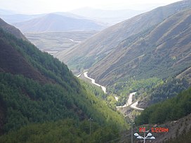
Mount Liupan (Chinese: 六盘山; pinyin: Lìupán Shān) is a mountain range in northwestern China, located mostly in southern Ningxia Hui Autonomous Region. It marks the southwestern boundary of the Ordos Basin.
Its southern section is known as Mount Long (Chinese: 陇山; pinyin: Lǒng Shān), which strides southeast through eastern Gansu and western Shaanxi province before joining into the Qinling Mountains, giving rise to regional names like "Longxi" (陇西, lit. "west of Mount Long"), "Longdong" (陇东, "east of Mount Long", referring to the Jing River valley basin region around eastern Pingliang, southern Qingyang and northern Xianyang) and "Longnan" (陇南, "south of Mount Long"). It is the western boundary of the Guanzhong Plain, and is also the source of the Qian River (千河), a left tributary of the Wei River that flows through the prefectural city of Baoji.
Poem of the same name
A poem of same name was dedicated to this mountain by Mao Zedong in 1935, when the Chinese Red Army arrived into the friendly Shaanbei region at the end of the Long March.
- 《清平乐·六盘山》
- 天高云淡,望断南飞雁。
- 不到长城非好汉,屈指行程二万。
- 六盘山上高峰,红旗漫卷西风。
- 今日长缨在手,何时缚住苍龙?
- Mount Liupan
- The sky is high, the clouds are pale,
- We watch the wild geese flying south until they vanish.
- If we reach not the Great Wall we are no true men,
- Already we have come twenty thousand li.
- High on the crest of Mount Liupan,
- Banners idly wave in the west wind.
- Today the long cord is in our hands,
- When shall we bind fast the Gray Dragon?
Geography
It is one of the youngest mountain ranges of China. It is relatively narrow with a width between 5 and 12 km, and a length of around 240 km. The highest peak, Migangshan (米缸山), is at 2,942 m (9,652 ft) above sea level. Owing to its orientation perpendicular to humid winds, it is considered a 'green island' within the Loess Plateau. Most of the mountain's area is covered by forests.
Climate
| Climate data for Mount Liupan (elevation 2,845 m (9,334 ft), 1991–2020 normals, extremes 1981–2010) | |||||||||||||
|---|---|---|---|---|---|---|---|---|---|---|---|---|---|
| Month | Jan | Feb | Mar | Apr | May | Jun | Jul | Aug | Sep | Oct | Nov | Dec | Year |
| Record high °C (°F) | 7.1 (44.8) |
11.4 (52.5) |
16.7 (62.1) |
21.7 (71.1) |
23.6 (74.5) |
23.1 (73.6) |
25.3 (77.5) |
23.6 (74.5) |
22.5 (72.5) |
17.0 (62.6) |
13.0 (55.4) |
8.1 (46.6) |
25.3 (77.5) |
| Mean daily maximum °C (°F) | −5.3 (22.5) |
−2.9 (26.8) |
1.6 (34.9) |
7.9 (46.2) |
12.1 (53.8) |
15.4 (59.7) |
17.1 (62.8) |
16.0 (60.8) |
11.6 (52.9) |
6.4 (43.5) |
1.0 (33.8) |
−3.8 (25.2) |
6.4 (43.6) |
| Daily mean °C (°F) | −9.9 (14.2) |
−7.7 (18.1) |
−3.4 (25.9) |
2.4 (36.3) |
6.8 (44.2) |
10.8 (51.4) |
12.7 (54.9) |
11.8 (53.2) |
7.6 (45.7) |
2.1 (35.8) |
−3.2 (26.2) |
−8.1 (17.4) |
1.8 (35.3) |
| Mean daily minimum °C (°F) | −13.0 (8.6) |
−10.9 (12.4) |
−6.6 (20.1) |
−1.2 (29.8) |
3.2 (37.8) |
7.5 (45.5) |
9.8 (49.6) |
9.0 (48.2) |
5.0 (41.0) |
−0.6 (30.9) |
−6.2 (20.8) |
−11.3 (11.7) |
−1.3 (29.7) |
| Record low °C (°F) | −25.3 (−13.5) |
−22.0 (−7.6) |
−23.0 (−9.4) |
−16.5 (2.3) |
−9.5 (14.9) |
−1.8 (28.8) |
3.6 (38.5) |
0.4 (32.7) |
−5.3 (22.5) |
−18.6 (−1.5) |
−21.3 (−6.3) |
−27.7 (−17.9) |
−27.7 (−17.9) |
| Average precipitation mm (inches) | 8.7 (0.34) |
12.1 (0.48) |
20.9 (0.82) |
34.8 (1.37) |
53.2 (2.09) |
92.4 (3.64) |
131.9 (5.19) |
129.1 (5.08) |
94.1 (3.70) |
46.3 (1.82) |
13.7 (0.54) |
4.7 (0.19) |
641.9 (25.26) |
| Average precipitation days (≥ 0.1 mm) | 7.4 | 7.6 | 8.4 | 8.9 | 10.7 | 13.4 | 15.8 | 15.1 | 14.4 | 10.7 | 6.7 | 4.6 | 123.7 |
| Average snowy days | 8.3 | 8.4 | 9.0 | 7.0 | 2.4 | 0.2 | 0 | 0.1 | 0.3 | 6.0 | 6.8 | 5.4 | 53.9 |
| Average relative humidity (%) | 62 | 65 | 64 | 61 | 63 | 70 | 79 | 82 | 81 | 73 | 65 | 58 | 69 |
| Mean monthly sunshine hours | 182.0 | 170.8 | 195.0 | 217.1 | 224.3 | 207.1 | 195.6 | 182.0 | 139.3 | 164.7 | 177.3 | 193.5 | 2,248.7 |
| Percent possible sunshine | 58 | 55 | 52 | 55 | 52 | 48 | 45 | 44 | 38 | 48 | 58 | 64 | 51 |
| Source: China Meteorological Administration | |||||||||||||
References
- ^ 古地理学报 (in Chinese). 科学出版社. 2009.
- Mao, Zedong; Schram, Stuart R. (1992). Mao's Road to Power - Revolutionary Writings, 1912-1949: The Pre-Marxist Period, 1912-1920. M.E. Sharpe. ISBN 978-1-56324-457-5.
- ^ 邓成龙 (2017-02-01). 诗词吟赏集 (in Chinese). Beijing Book Co. Inc. ISBN 978-7-227-06256-1.
- 中学地理教学 (in Chinese). 中国人民大学书报资料社. 1989.
- 中国气象数据网 – WeatherBk Data (in Simplified Chinese). China Meteorological Administration. Retrieved 10 October 2023.
- 中国气象数据网 (in Simplified Chinese). China Meteorological Administration. Retrieved 10 October 2023.
| Mountain ranges of China | |
|---|---|
| Geography of China | |
| Northwestern | |
| Qinghai-Tibet and Southwestern | |
| Northeast | |
| North and East | |
| Central | |
| South | |
Categories: