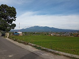
| Mount Malabar | |
|---|---|
 Mount Malabar seen from Soreang Mount Malabar seen from Soreang | |
| Highest point | |
| Elevation | 2,343 m (7,687 ft) |
| Coordinates | 7°08′S 107°39′E / 7.13°S 107.65°E / -7.13; 107.65 |
| Naming | |
| Native name | ᮌᮥᮔᮥᮀ ᮙᮜᮘᮁ |
| Geography | |
  | |
| Geology | |
| Mountain type | Stratovolcano |
| Last eruption | Pleistocene age |
Mount Malabar (Indonesian: Gunung Malabar) is a stratovolcano, located immediately south of Bandung, West Java, Indonesia. The profile is broad with basaltic andesite, type of geological stone.
See also
References
- ^ "Malabar". Global Volcanism Program. Smithsonian Institution. Retrieved 2021-06-24.
This West Java location article is a stub. You can help Misplaced Pages by expanding it. |