| Mount Mawson | |
|---|---|
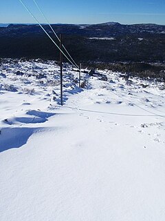
 Top of Mawson Run Top of Mawson Run | |
| Location | Mount Mawson, Mount Field |
| Nearest major city | Hobart |
| Top elevation | 1,320 metres (4,330 ft) |
| Base elevation | 1,250 metres (4,100 ft) AHD |
| Trails | 5 |
| Lift system | 4 rope tows |
| Website | mtmawson |
 | |
| Highest point | |
| Elevation | 1,318 m (4,324 ft)AHD |
| Prominence | 51 m (167 ft) |
| Listing | List of highest mountains of Tasmania |
| Coordinates | 42°21′43″S 146°34′28″E / 42.36194°S 146.57444°E / -42.36194; 146.57444 |
| Geography | |
| Location | Southern Tasmania, Australia |
| Geology | |
| Rock age | Jurassic |
| Mountain type | Dolerite |
Mount Mawson is a mountain and club skifield situated within the Mount Field National Park in southern Tasmania, Australia.
The mountain has an elevation of 1,318 metres (4,324 ft) above sea level. Mount Mawson's summit rises to 1,320 metres (4,330 ft) above sea level slightly lower than the 1,460 metres (4,790 ft) at Ben Lomond ski-field in northern Tasmania.
By road, the mountain is located 89 kilometres (55 mi) north west of Hobart and 232 kilometres (144 mi) from Launceston.
Skiing
Much of Tasmania is subject to at least occasional winter snows.
The Mount Mawson ski area was established as a club skifield in 1958 and is run by the Southern Tasmanian Ski Association. It is situated at around 1,250 metres (4,100 ft) above sea level with four ski tows about a 20-minute walk from the car park. Mawson has three lifts: two intermediate rope tows and a third steep incline rope tow accessing steep terrain. A small amount of club accommodation is available and there are some self-catering huts in the national park.
See also
References
- ^ "About". Mount Mawson. 2017. Retrieved 31 May 2017.
- ^ "Mount Mawson, Australia". Peakbagger.com. Retrieved 31 May 2017.
- "Mount Mawson". Gazetteer of Australia online. Geoscience Australia, Australian Government.
- Southern Tasmania Ski Association
- "Ski and winter". The Sydney Morning Herald. 13 November 2008. Archived from the original on 8 November 2012.
External links
- Wikiski entry Mount Mawson on WIkiski
- Mount Mawson website
- * Information on all ski lifts to have operated at Mt Mawsonin the Australian Ski Lift Directory
| Mountains in Tasmania, Australia | |||||||
|---|---|---|---|---|---|---|---|
| Arthur Range |
| ||||||
| Ben Lomond |
| ||||||
| Du Cane Range |
| ||||||
| Eldon Range |
| ||||||
| Great Western Tiers |
| ||||||
| Pelion Range |
| ||||||
| Wellington Range |
| ||||||
| West Coast Range |
| ||||||
| Not in a defined range |
| ||||||
| Highest summit elevation in Tasmania
| |||||||
| Australian skifields | |
|---|---|
| NSW | |
| Victoria | |
| Tasmania | |
| ACT | |
| Former skifields | |
This Tasmania geography article is a stub. You can help Misplaced Pages by expanding it. |
This article about a sports venue in Australia is a stub. You can help Misplaced Pages by expanding it. |