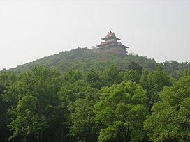
| Mount Mo | |
|---|---|
 | |
| Highest point | |
| Coordinates | 30°33′04″N 114°25′04″E / 30.551175°N 114.417914°E / 30.551175; 114.417914 |
| Geography | |
  | |
| Climbing | |
| Easiest route | cable car |
Mount Mo (Chinese: 磨山; pinyin: Mò Shān; lit. 'Millstone Mountain') (variously translated as Mo Hill, Moshan etc.), historically Mount Mo'er (Chinese: 磨儿山) and Mount Long (Chinese: 龙山), is a mountain of historical and cultural significance located on the southern shore of East Lake, a AAAAA Tourist Attraction of China in Hongshan District, Wuhan, Hubei.
Etymology
The 'Mo' in 'Mount Mo' refers to a millstone (Chinese: 石磨). The mountain is so named because it is round like a millstone.
History
Several hundred years ago, Mount Mo, then known as Mount Long, was the site of Fahua Temple. The temple had several hundred monks. Due to the spread of disease via mosquitoes, the temple was eventually abandoned.
After a Spring 1954 visit to Mount Mo by Zhu De, a pavilion was built in commemoration of the visit with the inscription, "东湖暂让西湖好,今后将比西湖强", meaning, 'For now East Lake is not as good as West Lake, but it will be stronger than West Lake.'
In an unusual event on June 22, 1999, at 7:35 PM, seven hundred trees at Mount Mo were knocked down by a wind coming off East Lake. There was speculation that the event was the result of UFO activity.
In 2004, Moshan Residential Community (磨山社区) was transferred from Guanshan Subdistrict to East Lake Scenic Area Subdistrict.
Scenic area
Mount Mo is a natural scenic area and includes many buildings that are reflective of Jingchu culture and are collectively referred to as 'Chu City' (楚城). The Chu City architecture was built in attempt to imitate the way that Ying had been built. The city gate is 23.4 meters tall and 105 meters long. The watchtower is 12.4 meters tall and the city wall is 11 meters tall.
Mount Mo includes East Lake Cherry Blossom Park and a Plum Blossom Park, which was designated as the Chinese Plum Blossom Research Center in 1992.
References
- "国家5A级景区查询". 中华人民共和国中央人民政府.
- ^ Chen, Zengtao (陈增涛) (28 August 2006). 磨山. 价值中国网 (in Chinese). Retrieved 2 November 2018.
- 东湖史话 page 97
- 东湖磨山倒树之谜 今日湖北 Hubei Today Monthly September 1999 page 10
- 央视《走近科学》栏目解读七年前磨山树倒之谜. cnhubei.com (in Chinese). 5 January 2007. Retrieved 2 November 2018.
- 洪山区历史沿革 [Hongshan District Historical Development] (in Simplified Chinese). XZQH.org. 7 July 2014. Retrieved 1 November 2018.
- 2017年统计用区划代码和城乡划分代码:东湖风景区街道(洪山) [2017 Statistical Area Numbers and Rural-Urban Area Numbers: East Lake Scenic Area Subdistrict (Hongshan)] (in Simplified Chinese). National Bureau of Statistics of the People's Republic of China. 2017. Retrieved 1 November 2018.
统计用区划代码 城乡分类代码 名称 420111491001 112 磨山社区居委会