| This article needs additional citations for verification. Please help improve this article by adding citations to reliable sources. Unsourced material may be challenged and removed. Find sources: "Mount Yahiko" – news · newspapers · books · scholar · JSTOR (February 2024) (Learn how and when to remove this message) |
| Mount Yahiko | |
|---|---|
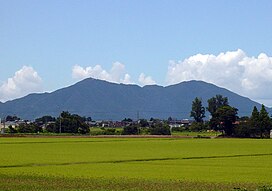
 Mount Yahiko (left) seen from Sakae PA Mount Yahiko (left) seen from Sakae PA | |
| Highest point | |
| Elevation | 634 m (2,080 ft) |
| Coordinates | 37°42′17″N 138°48′32″E / 37.70472°N 138.80889°E / 37.70472; 138.80889 |
| Geography | |
  | |
Mount Yahiko (弥彦山, Yahiko-yama) is a mountain located in Niigata Prefecture, Japan.
Yahikoyama Ropeway runs between the peak and the foot.

Gallery
-
Huge Torii gate and Mount Yahiko, near Yahagi Station
-
Peak of Mount Yahiko
-
 View from Mount Yahiko, June 2020
See also
References
- Ayalew, Lulseged; Yamagishi, Hiromitsu (2005). "The application of GIS-based logistic regression for landslide susceptibility mapping in the Kakuda-Yahiko Mountains, Central Japan". Geomorphology. 65 (1–2): 15–31. doi:10.1016/j.geomorph.2004.06.010.
This Niigata Prefecture location article is a stub. You can help Misplaced Pages by expanding it. |