| This article needs additional citations for verification. Please help improve this article by adding citations to reliable sources. Unsourced material may be challenged and removed. Find sources: "Nam District, Pohang" – news · newspapers · books · scholar · JSTOR (September 2018) (Learn how and when to remove this message) |
| Nam-gu 남구 | |
|---|---|
| Non-autonomous District | |
| Korean transcription(s) | |
| • Hanja | 南區 |
| • Revised Romanization | Nam-gu |
| • McCune–Reischauer | Nam-gu |
 | |
| Country | South Korea |
| Region | Yeongnam |
| Province | North Gyeongsang |
| City | Pohang |
| Administrative divisions | 7 dong, 3 eup, 4 myeon |
| Area | |
| • Total | 393.02 km (151.75 sq mi) |
| Population | |
| • Total | 253,670 |
| • Density | 645/km (1,670/sq mi) |
| • Dialect | Gyeongsang |
| Website | namgu.ipohang.org |
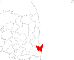
Nam District (Korean: 남구; RR: Nam-gu; lit. South District) is a non-autonomous district of Pohang, North Gyeongsang Province, South Korea. It is one of two districts in the city, the other being Buk District ("North District").
Administrative divisions


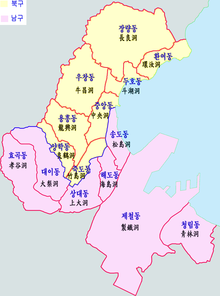
Nam-gu is divided into 3 towns (eup), 4 townships (myeon), and 7 neighbourhoods (dong).
| Hangul | Hanja | |
|---|---|---|
| Guryongpo-eup | 구룡포읍 | 九龍浦邑 |
| Yeonil-eup | 연일읍 | 延日邑 |
| Ocheon-eup | 오천읍 | 烏川邑 |
| Daesong-myeon | 대송면 | 大松面 |
| Donghae-myeon | 동해면 | 東海面 |
| Janggi-myeon | 장기면 | 長鬐面 |
| Homigot-myeon | 호미곶면 | 虎尾串面 |
| Sangdae-dong | 상대동 | 上大洞 |
| Haedo-dong | 해도동 | 海島洞 |
| Songdo-dong | 송도동 | 松島洞 |
| Cheongnim-dong | 청림동 | 靑林洞 |
| Jecheol-dong | 제철동 | 製鐵洞 |
| Hyogok-dong | 효곡동 | 孝谷洞 |
| Daei-dong | 대이동 | 大梨洞 |
Each town and township are then further divided into numerous villages (ri).
| eup/myeon/dong | ri | Hangeul | Hanja |
|---|---|---|---|
| Guryongpo-eup | Guryongpo-ri | 구룡포리 | 九龍浦里 |
| Samjeong-ri | 삼정리 | 三政里 | |
| Seokbyeong-ri | 석병리 | 石屛里 | |
| Nultae-ri | 눌태리 | 訥台里 | |
| Hudong-ri | 후동리 | 厚洞里 | |
| Byeongpo-ri | 병포리 | 柄浦里 | |
| Hajeong-ri | 하정리 | 河亭里 | |
| Janggil-ri | 장길리 | 長吉里 | |
| Gupyeong-ri | 평리 | 邱坪里 | |
| Seongdong-ri | 성동리 | 城洞里 | |
| Yeonil-eup | Ocheon-ri | 오천리 | 烏川里 |
| Saengji-ri | 생지리 | 生旨里 | |
| Goejeong-ri | 괴정리 | 槐亭里 | |
| Dongmun-ri | 동문리 | 東門里 | |
| Inju-ri | 인주리 | 絪珠里 | |
| Taekjeon-ri | 택전리 | 宅前里 | |
| Jungdan-ri | 중단리 | 中丹里 | |
| Jungmyeong-ri | 중명리 | 中明里 | |
| Ubok-ri | 우복리 | 牛伏里 | |
| Yugang-ri | 유강리 | 柳江里 | |
| Jamyeong-ri | 자명리 | 自明里 | |
| Hakjeon-ri | 학전리 | 鶴田里 | |
| Daljeon-ri | 달전리 | 達田里 | |
| Ocheon-eup | Mundeok-ri | 문덕리 | 文德里 |
| Gwangmyeong-ri | 광명리 | 光明里 | |
| Segye-ri | 세계리 | 世界里 | |
| Yongdeok-ri | 용덕리 | 龍德里 | |
| Won-ri | 원리 | 院里 | |
| Gujeong-ri | 구정리 | 舊政里 | |
| Yongsan-ri | 용산리 | 龍山里 | |
| Munchung-ri | 문충리 | 文忠里 | |
| Hangsa-ri | 항사리 | 恒沙里 | |
| Galpyeong-ri | 갈평리 | 葛坪里 | |
| Jinjeon-ri | 진전리 | 陳田里 | |
| Daesong-myeon | Namseong-ri | 남성리 | 南城里 |
| Jenae-ri | 제내리 | 堤內里 | |
| Songdong-ri | 송동리 | 松洞里 | |
| Ongmyeong-ri | 옥명리 | 玉明里 | |
| Gongsu-ri | 공수리 | 公須里 | |
| Jangdong-ri | 장동리 | 長洞里 | |
| Honggye-ri | 홍계리 | 洪溪里 | |
| Daegak-ri | 대각리 | 大覺里 | |
| Sanyeo-ri | 산여리 | 山余里 |
See also
References
- ^ "포항시 남구청 기본현황 인구/면적 - Nam-gu, Pohang City". Archived from the original on 2011-07-08.
External links
- (in Korean) Official website
| North Gyeongsang Province | ||||
|---|---|---|---|---|
| Andong (capital) | ||||
 | Specific city |
| ||
| Cities | ||||
| Counties | ||||
36°01′N 129°22′E / 36.01°N 129.36°E / 36.01; 129.36
This South Korea location article is a stub. You can help Misplaced Pages by expanding it. |