| Necochea Partido Partido de Necochea | |
|---|---|
| Department | |
 Coat of arms Coat of arms | |
 location of Necochea Partido in Buenos Aires Province location of Necochea Partido in Buenos Aires Province | |
| Coordinates: 38°33′S 58°44′W / 38.550°S 58.733°W / -38.550; -58.733 | |
| Country | Argentina |
| Established | July 19, 1865 |
| Founded by | Ángel Ignacio Murga |
| Seat | Necochea |
| Government | |
| • Mayor | Arturo Rojas (Nueva Necochea) |
| Area | |
| • Total | 4,455 km (1,720 sq mi) |
| Elevation | 16 m (52 ft) |
| Population | |
| • Total | 104,977 |
| • Density | 24/km (61/sq mi) |
| Demonym | necochense |
| Postal Code | B7630 |
| IFAM | BUE088 |
| Area Code | 02262 |
| Patron saint | Virgen del Carmen |
| Website | www |
Necochea is a coastal partido and city area in the southeast of the Buenos Aires Province, Argentina. The seat of the municipality is the port of Necochea.
The partido has a population of around 104,977 people, in an area of 4,455 km (1,720 sq mi). In the census of 2001 Neochea Partido had a population density of exactly 20.00 inhabitants per square kilometre (51.8/sq mi).

Geography
As of 2001 the district had about 90,000 inhabitants. The district covers an area of 4,455 km (1,720 sq mi) and lies about 530 kilometres (330 mi) south of Buenos Aires.
History
The partido was founded on July 19, 1865 and the settlement was founded on October 12, 1881 by Ángel Ignacio Murga.
The town of Necochea obtained its status as a city on July 26, 1911.

Geography
The partido has a salt-water lake known as El Lago de los Cisnes, (Swan's Lake).
Economy
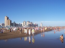
The economy of Necochea benefits from an influx of tourists from Gran Buenos Aires during the summer vacation season (December–February).
The main elements of the non-tourist economy are farming, the production of agricultural chemicals and biodiesel.
Settlements
- Necochea
- Balneario Los Ángeles
- Balneario Costa Bonita
- Energía
- La Dulce
- Juan Nepomuceno Fernández
- Ramón Santamarina y Claraz

This article about a place in Buenos Aires Province, Argentina is a stub. You can help Misplaced Pages by expanding it. |