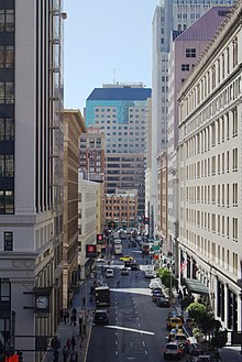
 New Montgomery Street, seen facing south across its Market Street terminus New Montgomery Street, seen facing south across its Market Street terminus | |
| Location | San Francisco, California |
|---|---|
| West end | Market Street in Union Square |
| East end | Howard Street in SoMa |

New Montgomery Street, formerly Montgomery Street South, begins at Market Street and terminates at Howard Street in the SOMA district of San Francisco, California.
History
Before New Montgomery Street was created, an inner street called Jane Street ran parallel to Second and Third Street. In the 1870s, Montgomery Street South was established in its place as the southern extension of Montgomery Street, one of the main thoroughfares in San Francisco's Financial District, running north from Market to Telegraph Hill. The extension was strongly supported by businessman and Bank of California founder William Ralston – who started the construction of the original Palace Hotel, at the time the largest hotel in the Western United States – in an effort to expand San Francisco's business district to the yet undeveloped area south of Market. Ralston's original plans to connect Montgomery Street to the waterfront failed due to the unwillingness of two property owners (governor Milton Latham and shipping baron John Parrott) to sell their mansions on Rincon Hill, which is why Montgomery Street South never got past Howard Street.
Notable buildings
Landmarks and notable buildings along New Montgomery Street include the Palace Hotel (1875, rebuilt in 1909), the Sharon Building (1912), the Montgomery (1914, headquarters of the San Francisco Call until 1950), the Rialto Building (1902, rebuilt in 1910) and San Francisco's first skyscraper the PacBell Building (1924). Among the companies headquartered on New Montgomery Street are OpenTable, Trulia, the Wikimedia Foundation, Lumosity, Terracotta, and, as of fall 2013, Yelp. New Montgomery Street is home to the main campus of the Academy of Art University.
Gallery
-
 The Garden Court at Palace Hotel
-
The Rialto Building
-
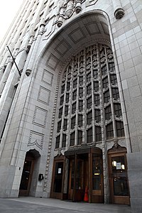
 The entrance of the PacBell Building
-
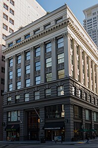
 The Montgomery
References
- Bloomfield, Anne B. "Commercial Development". Shaping San Francisco's Digital Archive. Archived from the original on 14 October 2013. Retrieved 28 August 2013.
- Fogelson, Robert M. (2003). Downtown: Its Rise and Fall, 1880-1950. Yale University Press. p. 114. ISBN 9780300098273.
- James Brook; Chris Carlsson; Nancy J. Peters, eds. (1998). Reclaiming San Francisco: History, Politics, Culture. City Lights Books. p. 107. ISBN 9780872863354.
- "The Silver Era, 1860-1870". Shaping San Francisco's Digital Archive. Retrieved 28 August 2013.
- Bevk, Alex (2012). "Then & Now: Latham Mansion/666 Folsom Street". Curbed. Retrieved 28 August 2013.
- Temple, James (28 August 2013). "Yelp signs Pacific Telephone Building lease to 2021". San Francisco Chronicle. Archived from the original on 8 October 2012. Retrieved 7 November 2012.
- "Academy of Art University Campus Map" (PDF). academyart.edu. Academy of Art University. Archived from the original (PDF) on 2 February 2017. Retrieved 23 November 2016.
| Streets in San Francisco | ||
|---|---|---|
| Numbered streets |  | |
| North–south streets |
| |
| East–west streets | ||
| Diagonal streets | ||
| Alleyways | ||
| San Francisco place names etymologies | ||
This San Francisco–related article is a stub. You can help Misplaced Pages by expanding it. |
This California road–related article is a stub. You can help Misplaced Pages by expanding it. |