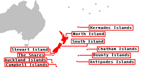
The New Zealand outlying islands are nine offshore island groups that are part of New Zealand, with all but Solander Islands lying beyond the 12nm limit of the mainland's territorial waters. Although considered integral parts of New Zealand, seven of the nine island groups are not part of any administrative region or district, but are instead each designated as an Area Outside Territorial Authority. The two exceptions are the Chatham Islands, which are covered by their own special territorial authority, and the Solander Islands, which are part of the Southland Region and Southland District.
Eight island groups sit on the New Zealand continental shelf, which forms a part of Zealandia. The Kermadec Islands, northeast of mainland New Zealand, are on a ridge, whose location as part or not part of Zealandia is not yet proven by geologists. Both sources show a map drawn of Zealandia, marking the location of islands north and south of New Zealand.
The term is also used sometimes to further encompass the Balleny Islands, a group of sub-Antarctic islands technically considered a part of the Ross Dependency and covered by the Antarctic Treaty.
The five island groups of the New Zealand Subantarctic Islands, including their territorial seas, are a World Heritage Site.
Island groups
The nine island groups classed as part of New Zealand's outlying islands are:
| Map | Island group (other names) |
Location | Coordinates | Area | Highest peak Altitude |
Notes |
|---|---|---|---|---|---|---|

|
Antipodes Islands (Moutere Mahue) |
New Zealand Subantarctic Islands, 860 kilometres (530 mi) east-southeast of Stewart Island / Rakiura | 49°41′S 178°48′E / 49.683°S 178.800°E / -49.683; 178.800 (Antipodes Islands) | 21 square kilometres (8.1 sq mi) | Mount Galloway 366 m (1,201 ft) |
Part of the New Zealand Subantarctic Islands World Heritage Site |

|
Auckland Islands (Motu Maha, Maungahuka) |
New Zealand Subantarctic Islands, 360 kilometres (220 mi) of Stewart Island / Rakiura | 50°42′S 166°05′E / 50.700°S 166.083°E / -50.700; 166.083 (Auckland Islands) | 625.64 square kilometres (241.56 sq mi) | Mount Dick 705 m (2,313 ft) |
Part of the New Zealand Subantarctic Islands World Heritage Site |

|
Bounty Islands (Moutere Hauriri) |
New Zealand Subantarctic Islands, roughly 670 km (416 mi) east-south-east of New Zealand's South Island and 530 km (329 mi) south-west of the Chatham Islands | 47°46′S 179°02′E / 47.767°S 179.033°E / -47.767; 179.033 (Bounty Islands) | 1.35 square kilometres (0.52 sq mi) | Unnamed point on Funnel Island 73 m (240 ft) |
Part of the New Zealand Subantarctic Islands World Heritage Site |

|
Campbell Islands (Motu Ihupuku) |
New Zealand Subantarctic Islands, 620 kilometres (390 mi) SSW of Stewart Island / Rakiura | 52°32′S 169°09′E / 52.533°S 169.150°E / -52.533; 169.150 (Campbell Islands) | 113.31 square kilometres (43.75 sq mi) | Mount Honey 558 m (1,831 ft) |
Part of the New Zealand Subantarctic Islands World Heritage Site |

|
Chatham Islands (Rēkohu, Wharekauri) |
South Pacific Ocean, roughly 800 kilometres (500 mi) east of New Zealand's South Island | 43°54′S 176°32′W / 43.900°S 176.533°W / -43.900; -176.533 (Chatham Islands) | 966 square kilometres (373 sq mi) | Unnamed point on Chatham Island 299 m (981 ft) |
Largest outlying island group, and the only one with a permanent population (720 as of June 2024). |

|
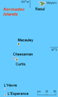
Kermadec Islands (Rangitāhua) |
South Pacific Ocean, roughly 800–1,000 kilometres (500–620 mi) north of New Zealand's North Island | 29°16′S 177°55′W / 29.267°S 177.917°W / -29.267; -177.917 (Kermadec Islands) | 33.6 square kilometres (13.0 sq mi) | Moumoukai Peak 516 m (1,693 ft) |
Northernmost outlying island group, consisting of a range of volcanic islands which are part of the wider Tonga-Kermadec Ridge. Despite having no permanent population, a meteorological station on Raoul Island is permanently staffed. |

|
Manawatāwhi / Three Kings Islands (Ngā Motu Karaka) |
Convergence of the Tasman Sea and the South Pacific Ocean, roughly 55 kilometres (34 mi) northwest of Cape Reinga / Te Rerenga Wairua | 34°09′S 172°08′E / 34.150°S 172.133°E / -34.150; 172.133 (Three Kings Islands) | 6.85 square kilometres (2.64 sq mi) | Unnamed point on Manawatāwhi / Great Island 295 m (968 ft) |
The islands are on a submarine plateau, the Three Kings Bank, and are separated from the New Zealand mainland by an 8 km wide, 200 to 300 m deep submarine trough |

|
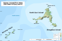
Snares Islands / Tini Heke (Te Taniwha) |
New Zealand Subantarctic Islands, 200 kilometres (120 mi) south of New Zealand's South Island | 48°01′S 166°32′E / 48.017°S 166.533°E / -48.017; 166.533 (The Snares) | 3.5 square kilometres (1.4 sq mi) | Unnamed point on North East Island 130 m (430 ft) |
Part of the New Zealand Subantarctic Islands World Heritage Site. Given a dual name with the Ngāi Tahu Claims Settlement Act 1998. |

|
Solander Islands / Hautere | West of the Foveaux Strait, roughly 50 kilometres (31 mi) south of Fiordland on New Zealand's South Island | 46°34′S 166°53′E / 46.567°S 166.883°E / -46.567; 166.883 (Solander Islands) | 1.2 square kilometres (0.46 sq mi) | Unnamed point on Solander Island / Hautere 330 m (1,080 ft) |
Only outlying island group to fall within the authority of a regional council, in this case Environment Southland. Given a dual name with the Ngāi Tahu Claims Settlement Act 1998. |
Population
The islands are all uninhabited except the Chatham Islands.
There is a staffed meteorological station on Raoul Island of the Kermadec Islands. The meteorological station on Campbell Island has been unstaffed and automated since 1995. There was a meteorological station on the Auckland Islands from 1942 to 1945. The Three Kings Islands and the Auckland Islands were formerly inhabited. There have been failed settlement attempts on Raoul Island, the Antipodes Islands and the Auckland Islands. The Solander Islands have never been inhabited except by shipwrecked sailors or marooned stowaways (for the longest period, from 1808 to 1813 by five European stowaways).
See also
- List of Antarctic and subantarctic islands
- List of islands of New Zealand
- New Zealand Subantarctic Islands
- Outlying Islands, Hong Kong
- United States Minor Outlying Islands
References
- Daly, Michael (17 February 2017). "New Zealand actually sits on a continent called Zealandia, it's just that most of it is under water". Stuff.co. Wellington, New Zealand. Retrieved 18 March 2022.
- Mortimer, Nick; Campbell, Hamish J.; Tulloch, Andy J.; King, Peter R.; Stagpoole, Vaughan M.; Wood, Ray A.; Rattenbury, Mark S.; Sutherland, Rupert; Adams, Chris J.; Collot, Julien; Seton, Maria (March–April 2017). "Zealandia: Earth's Hidden Continent". GSA Today. 27 (3): 27–35. doi:10.1130/GSATG321A.1. Retrieved 18 March 2022.
Several elevated bathymetric features north of Zealandia are possible candidates for Zealandia prolongations or separate microcontinents (Fig. 2). These include the Three Kings, Lau-Colville, and Tonga-Kermadec ridges and Fiji, which are known Cenozoic volcanic arcs (Graham, 2015), and the Mellish Rise and Louisiade and West Torres plateaus. However, no continental basement rocks have yet been sampled from any of these features, so their continental nature remains unproven.
- "New Zealand Sub-Antarctic Islands". UNESCO World Heritage Centre. Retrieved 8 November 2022.
- "Data Table – Protected Areas – LINZ Data Service (recorded area 2100 ha)". Land Information New Zealand. Retrieved 27 August 2019.
- "Data Table – Protected Areas – LINZ Data Service (recorded area 62564 ha)". Land Information New Zealand. Retrieved 27 August 2019.
- "Data Table – Protected Areas – LINZ Data Service (recorded area 135 ha)". Land Information New Zealand. Retrieved 27 August 2019.
- "Data Table – Protected Areas – LINZ Data Service (recorded area 11331 ha)". Land Information New Zealand. Retrieved 27 August 2019.
- "Data Table – Protected Areas – LINZ Data Service (recorded area 11331 ha)". Land Information New Zealand. Retrieved 27 August 2019.
- "Aotearoa Data Explorer". Statistics New Zealand. Retrieved 26 October 2024.
- "Data Table – Protected Areas – LINZ Data Service (recorded area 3359.9864 ha)". Land Information New Zealand. Retrieved 27 August 2019.
- "Data Table – Protected Areas – LINZ Data Service (recorded area 684.7281 ha)". Land Information New Zealand. Retrieved 27 August 2019.
- "Data Table – Protected Areas – LINZ Data Service (recorded area 120 ha)". Land Information New Zealand. Retrieved 27 August 2019.
- "Data Table – Protected Areas – LINZ Data Service (recorded area 350 ha)". Land Information New Zealand. Retrieved 27 August 2019.
External links
- New Zealand Subantarctic Islands Archived 5 December 2008 at the Wayback Machine
| Administrative divisions of the Realm of New Zealand | |||||||||||||||||||||||||||||||||||
|---|---|---|---|---|---|---|---|---|---|---|---|---|---|---|---|---|---|---|---|---|---|---|---|---|---|---|---|---|---|---|---|---|---|---|---|
| |||||||||||||||||||||||||||||||||||