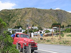
Place in Wellington, New Zealand
| Ngawi | |
|---|---|
 Ngawi Fishing Village Ngawi Fishing Village | |
 | |
| Coordinates: 41°35′15.34″S 175°14′5.08″E / 41.5875944°S 175.2347444°E / -41.5875944; 175.2347444 | |
| Country | |
| Region | Wellington |
| Territorial authority | South Wairarapa District |
| Ward | Ngawi |
| Time zone | UTC+12 (NZST) |
| • Summer (DST) | UTC+13 (NZDT) |
| Area code | 06 |
Ngawi (pronounced "ngaa-wee") is a small fishing / holiday village within five kilometres of Cape Palliser, the southern-most point of New Zealand's North Island.
The New Zealand Ministry for Culture and Heritage gives a translation of Ngāwī as "the native tussock grass".
The area is popular with commercial and recreational fishermen. The fishery includes pāua (a type of abalone which is prized for its iridescent shell as well as the flesh), crayfish, and cod.
Ngawi has more bulldozers per capita than anywhere else. The bulldozers are used to haul fishing boats into and out of the water as there is no wharf or other access to the ocean other than the beach, which can be notoriously rough. Crayfish (also known as rock lobster) are caught commercially for live export. In 2011, there were around a dozen commercial fishermen working from Ngawi, but most did not live in the village.
The village comprises mainly small wooden houses, called baches. The population is much larger during the summer season, when all the holiday homes are occupied. There are no shops in Ngawi, and the nearest school is at Pirinoa, around 37.5 kilometres (23.3 mi) to the north.
Ngawi is known for its exposed climate, its intense and prolonged wind and the fact that there are almost no trees nearby. The weather can be extremely hot in summer.
Several ships have been wrecked on the rough coastline.

In May 2006, filmmaker Peter Salmon shot a short film called 'Fog' in Ngawi. Salmon was drawn to the area's unique landscape and isolated feel. 'Fog' premiered at Critic's Week at the Cannes Film Festival in 2007. It stars Joe Dekkers-Reihana, Chelsie Crayford Preston, Jim Moriarty and Tina Cook.
41°35′15″S 175°14′05″E / 41.587595°S 175.234745°E / -41.587595; 175.234745
Climate
| Climate data for Ngawi (1991–2020) | |||||||||||||
|---|---|---|---|---|---|---|---|---|---|---|---|---|---|
| Month | Jan | Feb | Mar | Apr | May | Jun | Jul | Aug | Sep | Oct | Nov | Dec | Year |
| Mean daily maximum °C (°F) | 22.6 (72.7) |
22.6 (72.7) |
20.7 (69.3) |
18.1 (64.6) |
16.1 (61.0) |
13.8 (56.8) |
12.9 (55.2) |
13.6 (56.5) |
15.3 (59.5) |
17.1 (62.8) |
18.8 (65.8) |
21.0 (69.8) |
17.7 (63.9) |
| Daily mean °C (°F) | 18.7 (65.7) |
18.7 (65.7) |
17.2 (63.0) |
15.1 (59.2) |
13.4 (56.1) |
11.4 (52.5) |
10.5 (50.9) |
11.0 (51.8) |
12.4 (54.3) |
13.8 (56.8) |
15.3 (59.5) |
17.4 (63.3) |
14.6 (58.2) |
| Mean daily minimum °C (°F) | 14.8 (58.6) |
14.8 (58.6) |
13.7 (56.7) |
12.2 (54.0) |
10.8 (51.4) |
8.9 (48.0) |
8.1 (46.6) |
8.4 (47.1) |
9.5 (49.1) |
10.6 (51.1) |
11.8 (53.2) |
13.7 (56.7) |
11.4 (52.6) |
| Average rainfall mm (inches) | 61.9 (2.44) |
43.0 (1.69) |
68.3 (2.69) |
64.6 (2.54) |
69.8 (2.75) |
99.4 (3.91) |
114.5 (4.51) |
86.8 (3.42) |
71.7 (2.82) |
69.2 (2.72) |
66.3 (2.61) |
66.8 (2.63) |
882.3 (34.73) |
| Source: NIWA | |||||||||||||
References
- "1000 Māori place names". New Zealand Ministry for Culture and Heritage. 6 August 2019.
- "Ngawi". Destination Wairarapa. Retrieved 15 February 2016.
- ^ "Fur seals, crayfish and bulldozers: Off-the-beaten track in Cape Palliser". NZ Herald. Retrieved 27 November 2022.
- "AdelaideNow... Scenic solitude". Archived from the original on 22 August 2009.
- ^ Robinson, Katherine (18 February 2011). "The south coast village of Ngawi". Stuff. Retrieved 28 November 2022.
- "Fog". NZ On Screen. Retrieved 1 December 2022.
- "CliFlo – National Climate Database : Ngawi Aws". NIWA. Retrieved 20 May 2024.
| South Wairarapa District, New Zealand | |
|---|---|
| Seats: Martinborough | |
| Populated places | |
| Geographic features | |
| Facilities and attractions | |
| Railway stations | |
| Government | |
| Schools | |