| Noordwijkerhout | |
|---|---|
| Town and former municipality | |
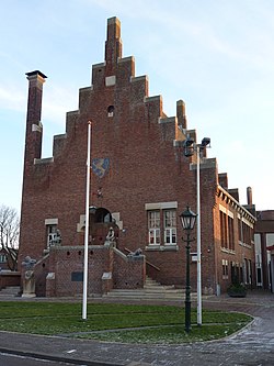
 Former City hall Former City hall | |
 Flag Flag | |
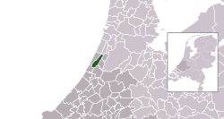
 Location in South Holland Location in South Holland | |
| Coordinates: 52°16′N 4°30′E / 52.267°N 4.500°E / 52.267; 4.500 | |
| Country | Netherlands |
| Province | South Holland |
| Municipality | Noordwijk |
| Area | |
| • Total | 23.42 km (9.04 sq mi) |
| • Land | 22.61 km (8.73 sq mi) |
| • Water | 0.81 km (0.31 sq mi) |
| Elevation | 3 m (10 ft) |
| Population | |
| • Total | data missing |
| Demonym | Noordwijkerhouter |
| Time zone | UTC+1 (CET) |
| • Summer (DST) | UTC+2 (CEST) |
| Postcode | 2190–2191, 2210–2211 |
| Area code | 0252 |
| Website | www |
Noordwijkerhout (Dutch pronunciation: [ˌnoːrtʋɛikərˈɦʌut] ) is a town and former municipality in the western part of the Netherlands, in the province of South Holland. The town is currently part of the municipality of Noordwijk and lies in the bulb-growing region (the Duin- en Bollenstreek) of the Netherlands, which is famed for its tulips.
The former municipality of Noordwijkerhout covered an area of 23.42 km (9.04 sq mi), of which 0.81 km (0.31 sq mi) was water, and had a population of data missing in 2021. It also included the village of De Zilk, which together with the town of Noordwijkerhout became part of the municipality of Noordwijk on 1 January 2019.
History
The coastal dunes where Noordwijkerhout is located have been inhabited since prehistoric times. Archaeological digs in the area just north outside of town have found items and implements from before Christ. During the Roman era, this region was inhabited by a Germanic tribe, called Cananefates by the Roman writer Tacitus.

Recreation and tourism
Noordwijkerhout is about 5 kilometers from the North Sea and provides access to the beach and nearby hiking opportunities through the dunes. Just north of town is the Oosterduinse meer (Eastern Dune's Lake) which is used for swimming and windsurfing. The center is also historical and have a church Witte kerkje.
Noordwijkerhout is located in an area called the "Dune and Bulb Region" (Duin- en Bollenstreek). In the spring when the bulb flower fields are in bloom, many tourist come to the region to admire them. The town's fair is held during the first week of September.
Dutch topographic map of the municipality of Noordwijkerhout, June 2015
Notable residents
International relations
See also: List of twin towns and sister cities in the NetherlandsTwin towns – Sister cities
Noordwijkerhout has one sister city in Japan
 Hirado, Nagasaki, Japan (Sister city)
References
- "Kerncijfers wijken en buurten 2020" [Key figures for neighbourhoods 2020]. StatLine (in Dutch). CBS. 24 July 2020. Retrieved 19 September 2020.
- "Postcodetool for 2211CC". Actueel Hoogtebestand Nederland (in Dutch). Het Waterschapshuis. Retrieved 16 August 2013.
- "Bevolkingsontwikkeling; regio per maand" [Population growth; regions per month]. CBS Statline (in Dutch). CBS. 1 January 2021. Retrieved 2 January 2022.
- "Gemeentelijke indeling op 1 januari 2019". CBS (in Dutch). Retrieved 9 December 2019.
- "The Canadian Encyclopedia".
- "Exchange programmes between Hirado and China, Hirado and Holland and other exchange programmes in Hirado City, Nagasaki Prefecture, Japan". City of Hirado, Nagasaki Official Website. Archived from the original on 2012-02-12. Retrieved 2013-12-17.
External links
| Places adjacent to Noordwijkerhout | ||||||||||||||||
|---|---|---|---|---|---|---|---|---|---|---|---|---|---|---|---|---|
| ||||||||||||||||
