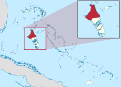
| District of North Andros North Andros | |
|---|---|
 | |
| Coordinates: 24°46′01″N 78°05′46″W / 24.76694°N 78.09611°W / 24.76694; -78.09611 | |
| Country | |
| Island | Andros |
| Established | 1996 |
| Government | |
| • Type | District Council |
| • Chief Councillor | Brian O’Neal Cleare |
| • Deputy Chief Councillor | Granville Coleby |
| Population | |
| • Total | 4,069 |
| Time zone | UTC−5 (EST) |
| • Summer (DST) | UTC−4 (EDT) |
| Area code | 242 |
North Andros is one of the 31 districts of the Bahamas. It is also the largest district (in area) in the country. It has some of the largest settlements on Andros Island and many churches as well. The population (2022 Census) is 4,069.
Churches
There are a number of church denominations represented within Andros. In North Andros, the Anglican Episcopal Church has a presence through St. Margaret's Parish. This parish consist of two churches: St. Margaret's, located in the settlement of Nicholl's Town; and St. Mary Magdalene, located in the settlement of Mastic Point. There are two denominations of Methodist Churches. (MCCA) Wesley Methodist church is located in Mastic Point, while Wesley Mt. Zion is at Nicholl's Town. (BCMC) Wesley Methodist is located at Mastic Point. There is also the Church of God of Prophecy. Branches may be found in Lowe Sound, Mastic Point, Staniard Creek and Conch Sound, the latter having the most membership. The Church of God of Prophecy in Conch Sound is home for the "Rushin" Bahamian Culture that is held on a yearly basis around New Year's time.
Settlements
Prevalent settlements in North Andros are:
- Red Bays
- Morgan's Bluff
- Lowe Sound
- Nicholls Town
- Conch Sound
- San Andros
- Mastic Point
- Stafford Creek
- Blanket Sound
- Staniard Creek
- Love Hill
Politics
For elections to the Parliament of the Bahamas, the district is part of the North Andros and Berry Islands constituency.
References
- "Census population and housing" (PDF). Bahamas Gov. Retrieved 17 April 2023.
- "Census population and housing" (PDF). Bahamas Gov. Retrieved 17 April 2023.
External
| Local government in the Bahamas | |
|---|---|
| Second-scheduled districts | |
| Third-scheduled districts | |
| Related | |
24°46′01″N 78°05′46″W / 24.76694°N 78.09611°W / 24.76694; -78.09611
This Bahamian location article is a stub. You can help Misplaced Pages by expanding it. |