Human settlement in England
| North Bitchburn | |
|---|---|
 | |
| OS grid reference | NZ172327 |
| Unitary authority | |
| Ceremonial county | |
| Region | |
| Country | England |
| Sovereign state | United Kingdom |
| Post town | Crook |
| Postcode district | DL15 |
| Police | Durham |
| Fire | County Durham and Darlington |
| Ambulance | North East |
| UK Parliament | |
| |

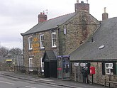
North Bitchburn is a small village in County Durham, England. It is situated 3 miles (4.8 km) north west of Bishop Auckland, near Howden-le-Wear. In the 2001 census North Bitchburn had a population of 135.
The village has a row of terrace houses named Low Row consisting of 20 houses. There are also estates called Wellgarth Court, North Bitchburn Terrace and Hillside Court. There is one public house, a Methodist chapel and one shop within the village centre. The public house is named 'The Red Lion'.
References
- Ordnance Survey: Landranger map sheet 92 Barnard Castle & Richmond (Teesdale) (Map). Ordnance Survey. 2011. ISBN 9780319228982.
- "Wear Valley Settlement Summary Sheets" (PDF). Durham County Council. Archived from the original (PDF) on 7 October 2007. Retrieved 19 February 2009.
This County Durham location article is a stub. You can help Misplaced Pages by expanding it. |