Census-designated place in Kentucky, United States
| Oneida | |
|---|---|
| Census-designated place (CDP) | |
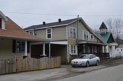
 Buildings along River Street Buildings along River Street | |
  | |
| Coordinates: 37°16′10″N 83°38′57″W / 37.26944°N 83.64917°W / 37.26944; -83.64917 | |
| Country | United States |
| State | Kentucky |
| County | Clay |
| Area | |
| • Total | 2.10 sq mi (5.43 km) |
| • Land | 2.04 sq mi (5.29 km) |
| • Water | 0.05 sq mi (0.14 km) |
| Elevation | 778 ft (237 m) |
| Population | |
| • Total | 370 |
| • Density | 181.37/sq mi (69.94/km) |
| Time zone | UTC-5 (Eastern Time Zone (EST)) |
| • Summer (DST) | UTC-4 (EST) |
| ZIP code | 40972 |
| Area code | 606 |
| FIPS code | 21-58062 |
| GNIS feature ID | 514357 |
Oneida (pronounced, oʊ ni: da:) is an unincorporated community and census-designated place (CDP) in Clay County, Kentucky, United States. Its population was 238 at the 2020 census. It is the home of Oneida Baptist Institute. Goose Creek, the Red Bird River, and Bullskin Creek confluence to form the South Fork of the Kentucky River a few hundred yards from the center of the town.
The major road that leads from the center of town to the Leslie County line is called "Bullskin".
Demographics
| Census | Pop. | Note | %± |
|---|---|---|---|
| 2010 | 410 | — | |
| 2020 | 238 | −42.0% | |
| U.S. Decennial Census | |||
Notable people
- James Anderson Burns, founder and first president of Oneida Baptist Institute
- Bert Combs, lawyer, officer in the Army, judge, politician, 50th Governor of Kentucky
- Jensen Huang, cofounder and CEO of Nvidia
- Anne Shelby, children's book writer
Climate
The climate in this area is characterized by hot, humid summers and generally mild to cool winters. According to the Köppen Climate Classification system, Oneida has a humid subtropical climate, abbreviated "Cfa" on climate maps.
References
- "2020 U.S. Gazetteer Files". United States Census Bureau. Retrieved March 18, 2022.
- "Oneida KY ZIP Code". zipdatamaps.com. 2023. Retrieved June 16, 2023.
- U.S. Geological Survey Geographic Names Information System: Oneida, Kentucky
- ^ "Oneida CDP, Kentucky - Census Bureau Profile". United States Census Bureau. Retrieved July 27, 2023.
- Climate Summary for Oneida, Kentucky
External links
| Municipalities and communities of Clay County, Kentucky, United States | ||
|---|---|---|
| County seat: Manchester | ||
| City |  | |
| CDPs | ||
| Other unincorporated communities | ||
| post offices (and the creeks they are on) |
| |
This Clay County, Kentucky state location article is a stub. You can help Misplaced Pages by expanding it. |